Söğüt elevation
Söğüt (Bilecik), Turkey elevation is 690 meters and Söğüt elevation in feet is 2264 ft above sea level [src 1]. Söğüt is a seat of a second-order administrative division (feature code) with elevation that is 33 meters (108 ft) smaller than average city elevation in Turkey.
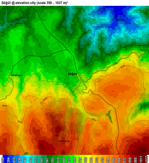
Below is the Elevation map of Söğüt, which displays elevation range with different colors. Scale of the first map is from 358 to 1037 m (1175 to 3402 ft) with average elevation of 728.7 meters (=2391 ft) [note 1]
These maps also provides idea of topography and contour of this city, they are displayed at different zoom levels. More info about maps, scale and edge coordinates you can find below images.
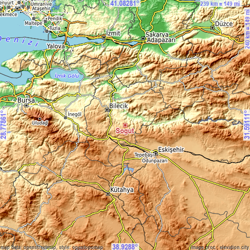
| \ | Map #1 | Topo.Map |
| Scale [m] | 358..1037 m | × |
| Scale [ft] | 1175..3402 ft | × |
| Average | 728.7 m = 2391 ft | × |
| Width | 7.48 km = 4.6 mi | 239.5 km = 148.8 mi |
| Height | 7.48 km = 4.6 mi | 239.5 km = 148.8 mi |
| ↑Max Latitude | 40.047949° | 41.08281° |
| Latitude at center | 40.0143° | 40.0143° |
| ↓Min Latitude | 39.980635° | 38.9288° |
| ← Min Longitude | 30.140915° | 28.77861° |
| Longitude center | 30.18486° | 30.18486° |
| →Max Longitude | 30.228805° | 31.59111° |
Nearby cities:
Cities around Söğüt sort by population:
• Bozüyük elevation 752 m
17.3 km,  226°
226°
• Bilecik 517 m
22.5 km,  309°
309°
• Mihalgazi 211 m
33.4 km,  87°
87°
• Gölpazarı 561 m
32.1 km,  20°
20°
• Pazaryeri 808 m
24 km,  264°
264°
• Vezirhan 163 m
29.2 km,  331°
331°
• İnhisar 227 m
17.5 km,  77°
77°
• Dodurga 1098 m
33 km,  223°
223°
• Yenipazar 619 m
33.8 km,  57°
57°
• Küplü 332 m
18.3 km,  300°
300°
• Hekimdağ 1249 m
34.4 km,  109°
109°
• İnönü 844 m
22.4 km,  188°
188°
Multilingual:
 En español:
Söğüt elevación 690 m.
 En France:
Söğüt élévation 690 m.


Sources and notes:
- [note 1] Map square and city borders are not equal. Map elevation data is calculated only from area inside that square.
- [src 1] Elevation data from geonames database provided with same terms of usage.
- [src 2] The elevation map of Söğüt is generated using elevation data from NASA's 3 arcsec (90m) resolution SRTM data.
- [src 3] Base (background) map © OpenStreetMap contributors tiles are generated by Geofabrik and OpenTopoMap.
Copyright & License:
This Söğüt Elevation Map is licensed under CC BY-SA. You may reuse any part from this page, if you give a proper credit by linking to this URL:
 More info on terms of use page.