Hamzalı elevation
Hamzalı (Diyarbakır), Turkey elevation is 1049 meters and Hamzalı elevation in feet is 3442 ft above sea level [src 1]. Hamzalı is a seat of a third-order administrative division (feature code) with elevation that is 326 meters (1070 ft) bigger than average city elevation in Turkey.
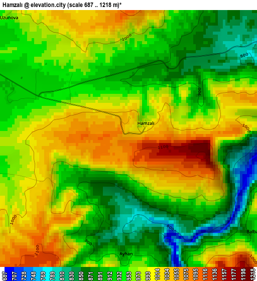
Below is the Elevation map of Hamzalı, which displays elevation range with different colors. Scale of the first map is from 687 to 1218 m (2254 to 3996 ft) with average elevation of 957.2 meters (=3140 ft) [note 1]
These maps also provides idea of topography and contour of this city, they are displayed at different zoom levels. More info about maps, scale and edge coordinates you can find below images.
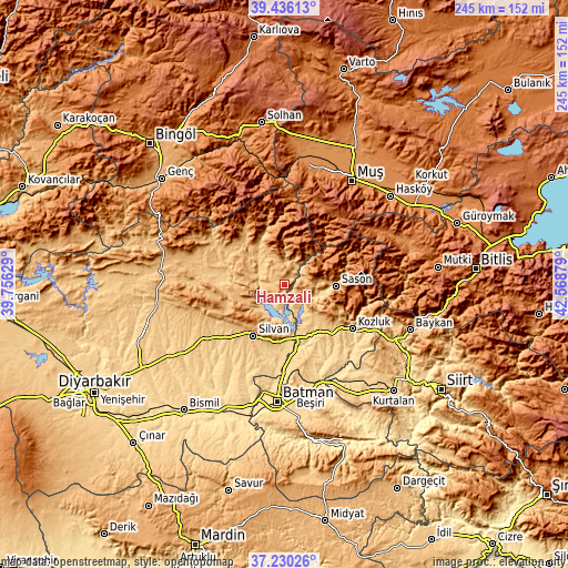
| \ | Map #1 | Topo.Map |
| Scale [m] | 687..1218 m | × |
| Scale [ft] | 2254..3996 ft | × |
| Average | 957.2 m = 3140 ft | × |
| Width | 7.66 km = 4.8 mi | 245.3 km = 152.4 mi |
| Height | 7.66 km = 4.8 mi | 245.3 km = 152.4 mi |
| ↑Max Latitude | 38.376049° | 39.43613° |
| Latitude at center | 38.34159° | 38.34159° |
| ↓Min Latitude | 38.307114° | 37.23026° |
| ← Min Longitude | 41.118595° | 39.75629° |
| Longitude center | 41.16254° | 41.16254° |
| →Max Longitude | 41.206485° | 42.56879° |
Nearby cities:
Cities around Hamzalı sort by population:
• Silvan elevation 810 m
26.4 km,  210°
210°
• Kozluk 937 m
32.2 km,  121°
121°
• Kulp 998 m
22 km,  321°
321°
• Sason 981 m
22 km,  94°
94°
• Hazro 980 m
35.7 km,  253°
253°
• Altınkum 656 m
12.3 km,  225°
225°
• Beyçayırı 627 m
39 km,  158°
158°
• Ağaçlı 1124 m
29.8 km,  310°
310°
• Bekirhan 645 m
25.1 km,  152°
152°
• Malabadi 613 m
21.4 km,  170°
170°
• Akçasır 1158 m
14.8 km,  37°
37°
• Yücebağ 1079 m
10.8 km,  57°
57°
Multilingual:
 En español:
Hamzalı elevación 1049 m.
 En France:
Hamzalı élévation 1049 m.
 Auf Deutsch:
Hamzalı höhe über dem Meeresspiegel ist 1049 m.

Sources and notes:
- [note 1] Map square and city borders are not equal. Map elevation data is calculated only from area inside that square.
- [src 1] Elevation data from geonames database provided with same terms of usage.
- [src 2] The elevation map of Hamzalı is generated using elevation data from NASA's 3 arcsec (90m) resolution SRTM data.
- [src 3] Base (background) map © OpenStreetMap contributors tiles are generated by Geofabrik and OpenTopoMap.
Copyright & License:
This Hamzalı Elevation Map is licensed under CC BY-SA. You may reuse any part from this page, if you give a proper credit by linking to this URL:
 More info on terms of use page.