Thung Hua Chang elevation
Thung Hua Chang (Lamphun), Thailand elevation is 567 meters and Thung Hua Chang elevation in feet is 1860 ft above sea level [src 1]. Thung Hua Chang is a seat of a second-order administrative division (feature code) with elevation that is 442 meters (1450 ft) bigger than average city elevation in Thailand.
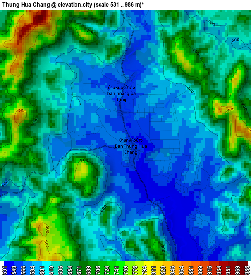
Below is the Elevation map of Thung Hua Chang, which displays elevation range with different colors. Scale of the first map is from 531 to 986 m (1742 to 3235 ft) with average elevation of 631.4 meters (=2072 ft) [note 1]
These maps also provides idea of topography and contour of this city, they are displayed at different zoom levels. More info about maps, scale and edge coordinates you can find below images.
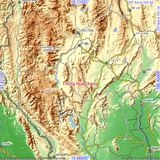
| \ | Map #1 | Topo.Map |
| Scale [m] | 531..986 m | × |
| Scale [ft] | 1742..3235 ft | × |
| Average | 631.4 m = 2072 ft | × |
| Width | 9.29 km = 5.8 mi | 297.4 km = 184.8 mi |
| Height | 9.29 km = 5.8 mi | 297.4 km = 184.8 mi |
| ↑Max Latitude | 18.044799° | 19.33523° |
| Latitude at center | 18.00301° | 18.00301° |
| ↓Min Latitude | 17.961211° | 16.66065° |
| ← Min Longitude | 98.983855° | 97.62155° |
| Longitude center | 99.0278° | 99.0278° |
| →Max Longitude | 99.071745° | 100.43405° |
Nearby cities:
Cities around Thung Hua Chang sort by population:
• Thoen elevation 170 m
47.7 km,  155°
155°
• Mae Tha 406 m
52.7 km,  13°
13°
• Wiang Nong Long 284 m
54.9 km,  327°
327°
• Mae Tha 250 m
53.4 km,  74°
74°
• Hang Chat 280 m
49.4 km,  42°
42°
• Hot 280 m
48.9 km,  295°
295°
• Ko Kha 223 m
44.1 km,  61°
61°
• Ban Hong 322 m
42.6 km, 328°
• Doi Tao 282 m
36.7 km,  261°
261°
• Sop Prap 200 m
35.4 km,  112°
112°
• Soem Ngam 248 m
24 km, 73°
• Li 458 m
23.7 km,  200°
200°
Multilingual:
 En español:
Thung Hua Chang elevación 567 m.
 En France:
Thung Hua Chang élévation 567 m.
 Auf Deutsch:
Thung Hua Chang höhe über dem Meeresspiegel ist 567 m.

Sources and notes:
- [note 1] Map square and city borders are not equal. Map elevation data is calculated only from area inside that square.
- [src 1] Elevation data from geonames database provided with same terms of usage.
- [src 2] The elevation map of Thung Hua Chang is generated using elevation data from NASA's 3 arcsec (90m) resolution SRTM data.
- [src 3] Base (background) map © OpenStreetMap contributors tiles are generated by Geofabrik and OpenTopoMap.
Copyright & License:
This Thung Hua Chang Elevation Map is licensed under CC BY-SA. You may reuse any part from this page, if you give a proper credit by linking to this URL:
 More info on terms of use page.