Hot elevation
Hot (Chiang Mai), Thailand elevation is 280 meters and Hot elevation in feet is 919 ft above sea level [src 1]. Hot is a seat of a second-order administrative division (feature code) with elevation that is 155 meters (509 ft) bigger than average city elevation in Thailand.
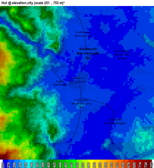
Below is the Elevation map of Hot, which displays elevation range with different colors. Scale of the first map is from 251 to 753 m (823 to 2470 ft) with average elevation of 326.4 meters (=1071 ft) [note 1]
These maps also provides idea of topography and contour of this city, they are displayed at different zoom levels. More info about maps, scale and edge coordinates you can find below images.
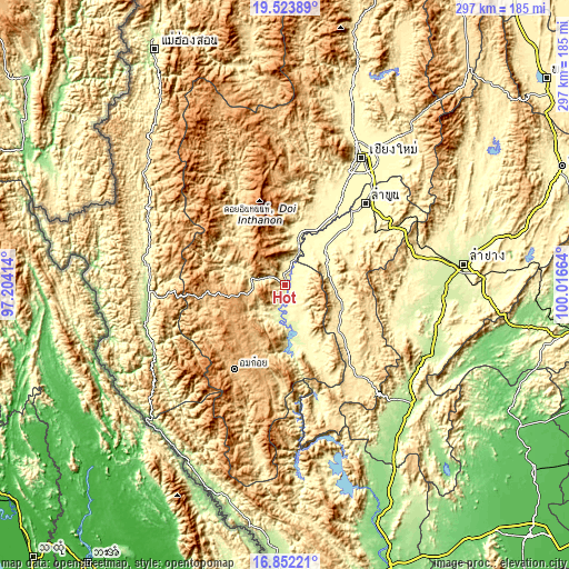
| \ | Map #1 | Topo.Map |
| Scale [m] | 251..753 m | × |
| Scale [ft] | 823..2470 ft | × |
| Average | 326.4 m = 1071 ft | × |
| Width | 9.28 km = 5.8 mi | 297.1 km = 184.6 mi |
| Height | 9.28 km = 5.8 mi | 297.1 km = 184.6 mi |
| ↑Max Latitude | 18.234913° | 19.52389° |
| Latitude at center | 18.19317° | 18.19317° |
| ↓Min Latitude | 18.151417° | 16.85221° |
| ← Min Longitude | 98.566445° | 97.20414° |
| Longitude center | 98.61039° | 98.61039° |
| →Max Longitude | 98.654335° | 100.01664° |
Nearby cities:
Cities around Hot sort by population:
• San Pa Tong elevation 300 m
57 km,  31°
31°
• Pa Sang 295 m
50.8 km,  43°
43°
• Chom Thong 287 m
25.8 km,  15°
15°
• Li 458 m
56.4 km,  140°
140°
• Om Koi 825 m
51 km,  211°
211°
• Mae Wang 335 m
50 km, 20°
• Thung Hua Chang 567 m
48.9 km,  115°
115°
• Mae Chaem 477 m
42.8 km,  322°
322°
• Doi Lo 303 m
34.6 km, 30°
• Wiang Nong Long 284 m
29.2 km, 30°
• Doi Tao 282 m
27.8 km,  163°
163°
• Ban Hong 322 m
26.8 km,  55°
55°
Multilingual:
 En español:
Hot elevación 280 m.
 En France:
Hot élévation 280 m.


Sources and notes:
- [note 1] Map square and city borders are not equal. Map elevation data is calculated only from area inside that square.
- [src 1] Elevation data from geonames database provided with same terms of usage.
- [src 2] The elevation map of Hot is generated using elevation data from NASA's 3 arcsec (90m) resolution SRTM data.
- [src 3] Base (background) map © OpenStreetMap contributors tiles are generated by Geofabrik and OpenTopoMap.
Copyright & License:
This Hot Elevation Map is licensed under CC BY-SA. You may reuse any part from this page, if you give a proper credit by linking to this URL:
 More info on terms of use page.