Mae Chaem elevation
Mae Chaem (Chiang Mai), Thailand elevation is 477 meters and Mae Chaem elevation in feet is 1565 ft above sea level [src 1]. Mae Chaem is a seat of a second-order administrative division (feature code) with elevation that is 352 meters (1155 ft) bigger than average city elevation in Thailand.
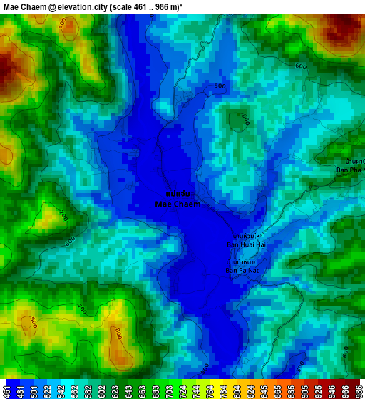
Below is the Elevation map of Mae Chaem, which displays elevation range with different colors. Scale of the first map is from 461 to 986 m (1512 to 3235 ft) with average elevation of 589.8 meters (=1935 ft) [note 1]
These maps also provides idea of topography and contour of this city, they are displayed at different zoom levels. More info about maps, scale and edge coordinates you can find below images.
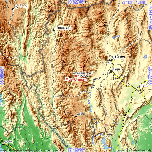
| \ | Map #1 | Topo.Map |
| Scale [m] | 461..986 m | × |
| Scale [ft] | 1512..3235 ft | × |
| Average | 589.8 m = 1935 ft | × |
| Width | 9.27 km = 5.8 mi | 296.5 km = 184.2 mi |
| Height | 9.27 km = 5.8 mi | 296.6 km = 184.3 mi |
| ↑Max Latitude | 18.540929° | 19.82755° |
| Latitude at center | 18.49926° | 18.49926° |
| ↓Min Latitude | 18.45758° | 17.16059° |
| ← Min Longitude | 98.320995° | 96.95869° |
| Longitude center | 98.36494° | 98.36494° |
| →Max Longitude | 98.408885° | 99.77119° |
Nearby cities:
Cities around Mae Chaem sort by population:
• San Pa Tong elevation 300 m
57.8 km,  75°
75°
• Chom Thong 287 m
33.9 km,  105°
105°
• Khun Yuam 620 m
58.4 km,  308°
308°
• Ban Huai I Huak 922 m
58.3 km,  216°
216°
• Samoeng 507 m
54.8 km,  44°
44°
• Ban Hong 322 m
51.5 km, 111°
• Mae La Noi 324 m
46.3 km,  253°
253°
• Mae Wang 335 m
44.9 km,  73°
73°
• Doi Lo 303 m
43.7 km,  95°
95°
• Hot 280 m
42.8 km,  142°
142°
• Wiang Nong Long 284 m
41.5 km, 102°
• Ban Pa Pae 745 m
40.4 km,  233°
233°
Multilingual:
 En español:
Mae Chaem elevación 477 m.
 En France:
Mae Chaem élévation 477 m.
 Auf Deutsch:
Mae Chaem höhe über dem Meeresspiegel ist 477 m.

Sources and notes:
- [note 1] Map square and city borders are not equal. Map elevation data is calculated only from area inside that square.
- [src 1] Elevation data from geonames database provided with same terms of usage.
- [src 2] The elevation map of Mae Chaem is generated using elevation data from NASA's 3 arcsec (90m) resolution SRTM data.
- [src 3] Base (background) map © OpenStreetMap contributors tiles are generated by Geofabrik and OpenTopoMap.
Copyright & License:
This Mae Chaem Elevation Map is licensed under CC BY-SA. You may reuse any part from this page, if you give a proper credit by linking to this URL:
 More info on terms of use page.