Umphang elevation
Umphang (Tak), Thailand elevation is 461 meters and Umphang elevation in feet is 1512 ft above sea level [src 1]. Umphang is a seat of a second-order administrative division (feature code) with elevation that is 336 meters (1102 ft) bigger than average city elevation in Thailand.
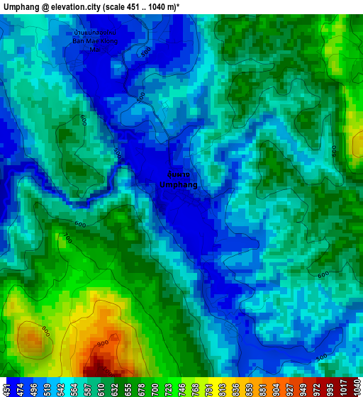
Below is the Elevation map of Umphang, which displays elevation range with different colors. Scale of the first map is from 451 to 1040 m (1480 to 3412 ft) with average elevation of 591.1 meters (=1939 ft) [note 1]
These maps also provides idea of topography and contour of this city, they are displayed at different zoom levels. More info about maps, scale and edge coordinates you can find below images.
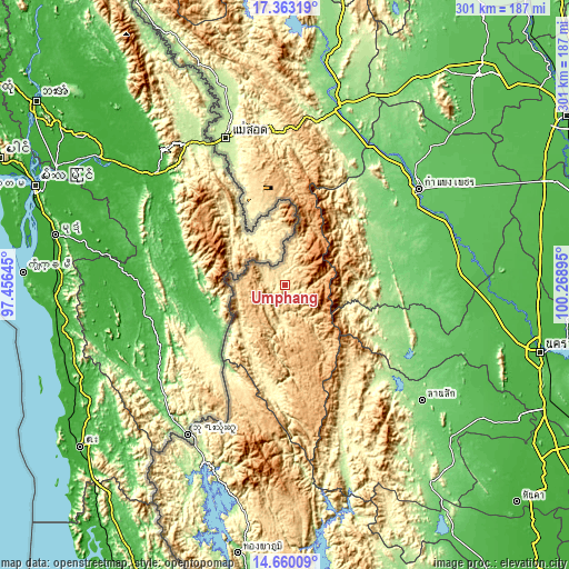
| \ | Map #1 | Topo.Map |
| Scale [m] | 451..1040 m | × |
| Scale [ft] | 1480..3412 ft | × |
| Average | 591.1 m = 1939 ft | × |
| Width | 9.39 km = 5.8 mi | 300.6 km = 186.8 mi |
| Height | 9.39 km = 5.8 mi | 300.6 km = 186.8 mi |
| ↑Max Latitude | 16.058455° | 17.36319° |
| Latitude at center | 16.01622° | 16.01622° |
| ↓Min Latitude | 15.973976° | 14.66009° |
| ← Min Longitude | 98.818755° | 97.45645° |
| Longitude center | 98.8627° | 98.8627° |
| →Max Longitude | 98.906645° | 100.26895° |
Nearby cities:
Cities around Umphang sort by population:
• Kamphaeng Phet elevation 83 m
87.4 km,  53°
53°
• Mae Sot 213 m
84 km,  337°
337°
• Lan Sak 112 m
98.8 km,  129°
129°
• Khlong Khlung 62 m
94.1 km,  76°
76°
• Kosamphi Nakhon 96 m
85.9 km,  37°
37°
• Chum Ta Bong 101 m
85.3 km,  120°
120°
• Wang Chao 105 m
85.1 km,  30°
30°
• Mae Poen 133 m
76.2 km, 121°
• Mae Wong 129 m
74.8 km,  110°
110°
• Pang Sila Thong 97 m
67.5 km, 82°
• Khlong Lan 158 m
53.1 km,  66°
66°
• Phop Phra 370 m
44.9 km, 335°
Multilingual:
 En español:
Umphang elevación 461 m.
 En France:
Umphang élévation 461 m.


Sources and notes:
- [note 1] Map square and city borders are not equal. Map elevation data is calculated only from area inside that square.
- [src 1] Elevation data from geonames database provided with same terms of usage.
- [src 2] The elevation map of Umphang is generated using elevation data from NASA's 3 arcsec (90m) resolution SRTM data.
- [src 3] Base (background) map © OpenStreetMap contributors tiles are generated by Geofabrik and OpenTopoMap.
Copyright & License:
This Umphang Elevation Map is licensed under CC BY-SA. You may reuse any part from this page, if you give a proper credit by linking to this URL:
 More info on terms of use page.