Pang Sila Thong elevation
Pang Sila Thong (Kamphaeng Phet), Thailand elevation is 97 meters and Pang Sila Thong elevation in feet is 318 ft above sea level [src 1]. Pang Sila Thong is a seat of a second-order administrative division (feature code) with elevation that is 28 meters (92 ft) smaller than average city elevation in Thailand.
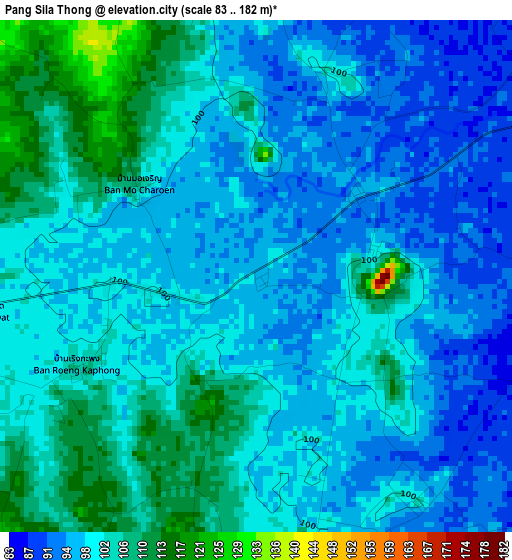
Below is the Elevation map of Pang Sila Thong, which displays elevation range with different colors. Scale of the first map is from 83 to 182 m (272 to 597 ft) with average elevation of 100.1 meters (=328 ft) [note 1]
These maps also provides idea of topography and contour of this city, they are displayed at different zoom levels. More info about maps, scale and edge coordinates you can find below images.
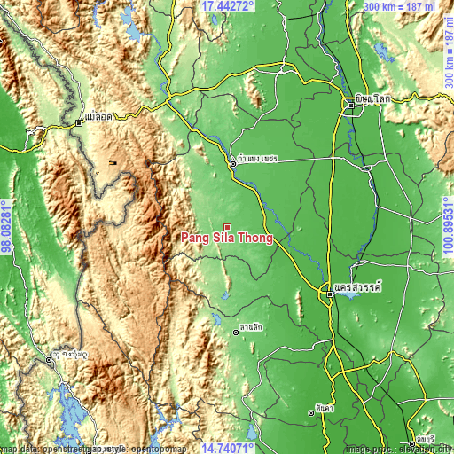
| \ | Map #1 | Topo.Map |
| Scale [m] | 83..182 m | × |
| Scale [ft] | 272..597 ft | × |
| Average | 100.1 m = 328 ft | × |
| Width | 9.39 km = 5.8 mi | 300.4 km = 186.7 mi |
| Height | 9.39 km = 5.8 mi | 300.5 km = 186.7 mi |
| ↑Max Latitude | 16.138528° | 17.44272° |
| Latitude at center | 16.09631° | 16.09631° |
| ↓Min Latitude | 16.054083° | 14.74071° |
| ← Min Longitude | 99.445115° | 98.08281° |
| Longitude center | 99.48906° | 99.48906° |
| →Max Longitude | 99.533005° | 100.89531° |
Nearby cities:
Cities around Pang Sila Thong sort by population:
• Kamphaeng Phet elevation 83 m
43.2 km,  4°
4°
• Khanu Woralaksaburi 52 m
39.9 km,  95°
95°
• Lat Yao 62 m
50 km,  140°
140°
• Sai Ngam 59 m
59.4 km,  45°
45°
• Banphot Phisai 46 m
55.6 km,  108°
108°
• Bueng Samakkhi 49 m
52.9 km,  78°
78°
• Chum Ta Bong 101 m
52.1 km,  172°
172°
• Mae Poen 133 m
48.8 km,  182°
182°
• Thung Sai 57 m
44 km,  56°
56°
• Mae Wong 129 m
35.1 km, 174°
• Khlong Khlung 62 m
28 km, 61°
• Khlong Lan 158 m
21.6 km,  303°
303°
Multilingual:
 En español:
Pang Sila Thong elevación 97 m.
 En France:
Pang Sila Thong élévation 97 m.
 Auf Deutsch:
Pang Sila Thong höhe über dem Meeresspiegel ist 97 m.

Sources and notes:
- [note 1] Map square and city borders are not equal. Map elevation data is calculated only from area inside that square.
- [src 1] Elevation data from geonames database provided with same terms of usage.
- [src 2] The elevation map of Pang Sila Thong is generated using elevation data from NASA's 3 arcsec (90m) resolution SRTM data.
- [src 3] Base (background) map © OpenStreetMap contributors tiles are generated by Geofabrik and OpenTopoMap.
Copyright & License:
This Pang Sila Thong Elevation Map is licensed under CC BY-SA. You may reuse any part from this page, if you give a proper credit by linking to this URL:
 More info on terms of use page.