Lan Sak elevation
Lan Sak (Uthai Thani), Thailand elevation is 112 meters and Lan Sak elevation in feet is 367 ft above sea level [src 1]. Lan Sak is a seat of a second-order administrative division (feature code) with elevation that is 13 meters (43 ft) smaller than average city elevation in Thailand.
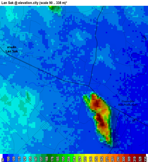
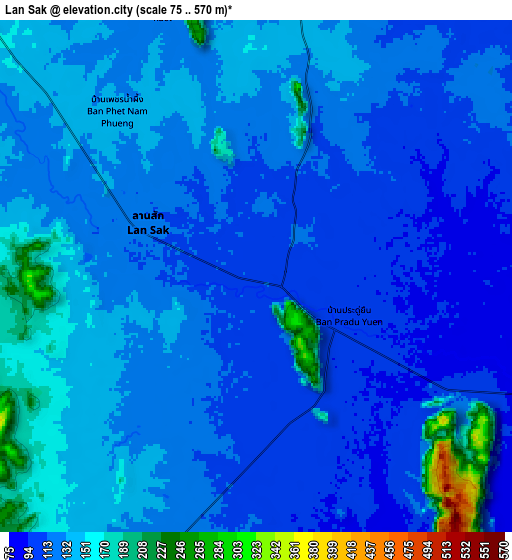
Below is the Elevation map of Lan Sak, which displays elevation range with different colors. Scale of the first map is from 90 to 338 m (295 to 1109 ft) with average elevation of 116.1 meters (=381 ft) [note 1]
These maps also provides idea of topography and contour of this city, they are displayed at different zoom levels. More info about maps, scale and edge coordinates you can find below images.
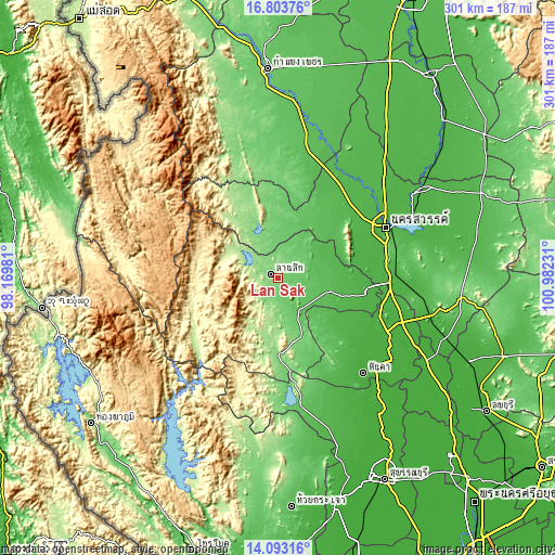
| \ | Map #1 | Map #2 | Topo.Map |
| Scale [m] | 90..338 m | 75..570 m | × |
| Scale [ft] | 295..1109 ft | 246..1870 ft | × |
| Average | 116.1 m = 381 ft | 128.6 m = 422 ft | × |
| Width | 9.42 km = 5.9 mi | 18.84 km = 11.7 mi | 301.4 km = 187.3 mi |
| Height | 9.42 km = 5.9 mi | 18.84 km = 11.7 mi | 301.4 km = 187.3 mi |
| ↑Max Latitude | 15.495242° | 15.537586° | 16.80376° |
| Latitude at center | 15.45289° | 15.45289° | 15.45289° |
| ↓Min Latitude | 15.410529° | 15.368159° | 14.09316° |
| ← Min Longitude | 99.532115° | 99.488169° | 98.16981° |
| Longitude center | 99.57606° | 99.57606° | 99.57606° |
| →Max Longitude | 99.620005° | 99.663951° | 100.98231° |
Nearby cities:
Cities around Lan Sak sort by population:
• Uthai Thani elevation 28 m
48.8 km,  99°
99°
• Lat Yao 62 m
40.2 km,  34°
34°
• Thap Than 45 m
33.8 km,  88°
88°
• Huai Khot 106 m
18.5 km,  166°
166°
• Ban Rai 160 m
41.4 km,  188°
188°
• Nong Kha Yang 41 m
39.1 km, 104°
• Mae Wong 129 m
37.1 km,  350°
350°
• Nong Mamong 47 m
36.8 km,  122°
122°
• Sawang Arom 44 m
33.8 km,  64°
64°
• Nong Chang 54 m
29.3 km, 103°
• Mae Poen 133 m
25.5 km,  333°
333°
• Chum Ta Bong 101 m
20.1 km, 352°
Multilingual:
 En español:
Lan Sak elevación 112 m.
 En France:
Lan Sak élévation 112 m.


Sources and notes:
- [note 1] Map square and city borders are not equal. Map elevation data is calculated only from area inside that square.
- [src 1] Elevation data from geonames database provided with same terms of usage.
- [src 2] The elevation map of Lan Sak is generated using elevation data from NASA's 3 arcsec (90m) resolution SRTM data.
- [src 3] Base (background) map © OpenStreetMap contributors tiles are generated by Geofabrik and OpenTopoMap.
Copyright & License:
This Lan Sak Elevation Map is licensed under CC BY-SA. You may reuse any part from this page, if you give a proper credit by linking to this URL:
 More info on terms of use page.