Mae Sot elevation
Mae Sot (Tak), Thailand elevation is 213 meters and Mae Sot elevation in feet is 699 ft above sea level [src 1]. Mae Sot is a seat of a second-order administrative division (feature code) with elevation that is 88 meters (289 ft) bigger than average city elevation in Thailand.
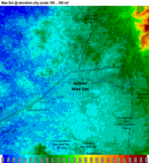
Below is the Elevation map of Mae Sot, which displays elevation range with different colors. Scale of the first map is from 189 to 309 m (620 to 1014 ft) with average elevation of 214.9 meters (=705 ft) [note 1]
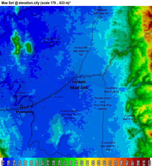
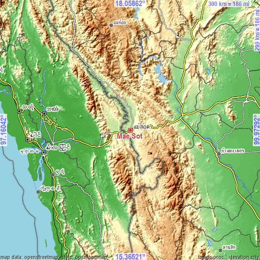
These maps also provides idea of topography and contour of this city, they are displayed at different zoom levels. More info about maps, scale and edge coordinates you can find below images.
| \ | Map #1 | Map #2 | Topo.Map |
| Scale [m] | 189..309 m | 179..633 m | × |
| Scale [ft] | 620..1014 ft | 587..2077 ft | × |
| Average | 214.9 m = 705 ft | 244.6 m = 802 ft | × |
| Width | 9.36 km = 5.8 mi | 18.72 km = 11.6 mi | 299.5 km = 186.1 mi |
| Height | 9.36 km = 5.8 mi | 18.72 km = 11.6 mi | 299.5 km = 186.1 mi |
| ↑Max Latitude | 16.758753° | 16.800828° | 18.05862° |
| Latitude at center | 16.71667° | 16.71667° | 16.71667° |
| ↓Min Latitude | 16.674577° | 16.632475° | 15.36521° |
| ← Min Longitude | 98.522725° | 98.478779° | 97.16042° |
| Longitude center | 98.56667° | 98.56667° | 98.56667° |
| →Max Longitude | 98.610615° | 98.654561° | 99.97292° |
Nearby cities:
Cities around Mae Sot sort by population:
• Kamphaeng Phet elevation 83 m
105 km,  104°
104°
• Tak 113 m
62.2 km,  74°
74°
• Ban Tak 148 m
65.7 km,  56°
56°
• Mae Ramat 184 m
30.2 km,  349°
349°
• Mae Phrik 162 m
99.9 km,  35°
35°
• Khlong Lan 158 m
98.5 km,  125°
125°
• Umphang 461 m
84 km,  157°
157°
• Kosamphi Nakhon 96 m
83.9 km, 96°
• Sam Ngao 145 m
76 km, 39°
• Wang Chao 105 m
75 km,  93°
93°
• Tha Song Yang 142 m
67.3 km,  327°
327°
• Phop Phra 370 m
39.2 km, 160°
Multilingual:
 En español:
Mae Sot elevación 213 m.
 En France:
Mae Sot élévation 213 m.


Sources and notes:
- [note 1] Map square and city borders are not equal. Map elevation data is calculated only from area inside that square.
- [src 1] Elevation data from geonames database provided with same terms of usage.
- [src 2] The elevation map of Mae Sot is generated using elevation data from NASA's 3 arcsec (90m) resolution SRTM data.
- [src 3] Base (background) map © OpenStreetMap contributors tiles are generated by Geofabrik and OpenTopoMap.
Copyright & License:
This Mae Sot Elevation Map is licensed under CC BY-SA. You may reuse any part from this page, if you give a proper credit by linking to this URL:
 More info on terms of use page.