Ghabāghib elevation
Ghabāghib (Daraa), Syria elevation is 698 meters and Ghabāghib elevation in feet is 2290 ft above sea level [src 1]. Ghabāghib is a seat of a third-order administrative division (feature code) with elevation that is 169 meters (554 ft) bigger than average city elevation in Syria.
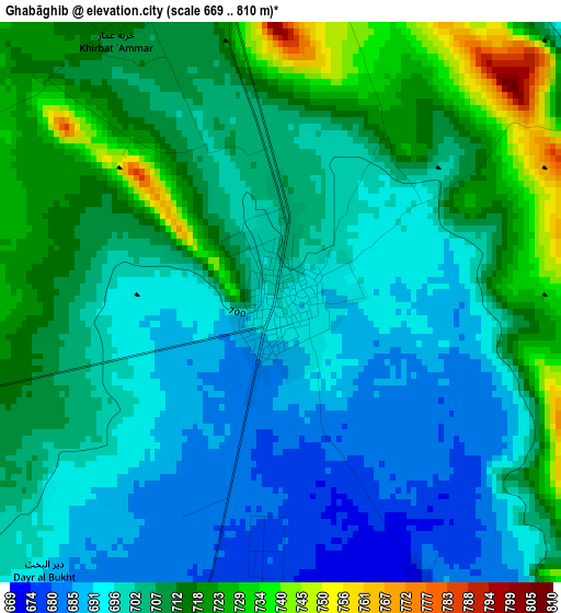
Below is the Elevation map of Ghabāghib, which displays elevation range with different colors. Scale of the first map is from 669 to 810 m (2195 to 2657 ft) with average elevation of 704.8 meters (=2312 ft) [note 1]
These maps also provides idea of topography and contour of this city, they are displayed at different zoom levels. More info about maps, scale and edge coordinates you can find below images.
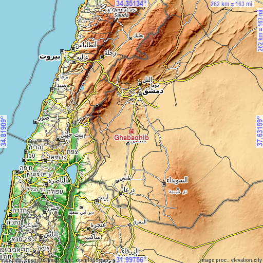
| \ | Map #1 | Topo.Map |
| Scale [m] | 669..810 m | × |
| Scale [ft] | 2195..2657 ft | × |
| Average | 704.8 m = 2312 ft | × |
| Width | 8.18 km = 5.1 mi | 261.7 km = 162.6 mi |
| Height | 8.18 km = 5.1 mi | 261.7 km = 162.6 mi |
| ↑Max Latitude | 33.219122° | 34.35134° |
| Latitude at center | 33.18235° | 33.18235° |
| ↓Min Latitude | 33.145563° | 31.99756° |
| ← Min Longitude | 36.181395° | 34.81909° |
| Longitude center | 36.22534° | 36.22534° |
| →Max Longitude | 36.269285° | 37.63159° |
Nearby cities:
Cities around Ghabāghib sort by population:
• Dārayyā elevation 703 m
30.7 km,  1°
1°
• Jāsim 657 m
26.1 km,  216°
216°
• Inkhil 623 m
20.4 km,  206°
206°
• Aş Şanamayn 642 m
12.9 km,  197°
197°
• Al Kiswah 724 m
19.6 km, 4°
• Qaţanā 897 m
31.5 km,  334°
334°
• Al Ghizlānīyah 622 m
32 km,  41°
41°
• Al Ḩajar al Aswad 676 m
31.5 km,  13°
13°
• Khān Arnabah 944 m
31.1 km,  270°
270°
• Sahnaiya 705 m
27 km, 0°
• Sa‘sa‘ 888 m
22.1 km,  300°
300°
• Mismīyah 618 m
16.8 km,  110°
110°
Multilingual:
 En español:
Ghabāghib elevación 698 m.
 En France:
Ghabāghib élévation 698 m.
 Auf Deutsch:
Ghabāghib höhe über dem Meeresspiegel ist 698 m.

Sources and notes:
- [note 1] Map square and city borders are not equal. Map elevation data is calculated only from area inside that square.
- [src 1] Elevation data from geonames database provided with same terms of usage.
- [src 2] The elevation map of Ghabāghib is generated using elevation data from NASA's 3 arcsec (90m) resolution SRTM data.
- [src 3] Base (background) map © OpenStreetMap contributors tiles are generated by Geofabrik and OpenTopoMap.
Copyright & License:
This Ghabāghib Elevation Map is licensed under CC BY-SA. You may reuse any part from this page, if you give a proper credit by linking to this URL:
 More info on terms of use page.