Inkhil elevation
Inkhil (Daraa), Syria elevation is 623 meters and Inkhil elevation in feet is 2044 ft above sea level [src 1]. Inkhil is a populated place (feature code) with elevation that is 94 meters (308 ft) bigger than average city elevation in Syria.
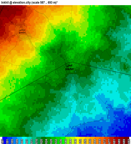
Below is the Elevation map of Inkhil, which displays elevation range with different colors. Scale of the first map is from 587 to 693 m (1926 to 2274 ft) with average elevation of 628.3 meters (=2061 ft) [note 1]
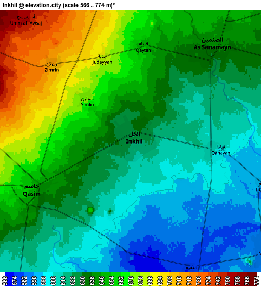
These maps also provides idea of topography and contour of this city, they are displayed at different zoom levels. More info about maps, scale and edge coordinates you can find below images.
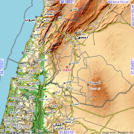
| \ | Map #1 | Map #2 | Topo.Map |
| Scale [m] | 587..693 m | 566..774 m | × |
| Scale [ft] | 1926..2274 ft | 1857..2539 ft | × |
| Average | 628.3 m = 2061 ft | 636.4 m = 2088 ft | × |
| Width | 8.19 km = 5.1 mi | 16.39 km = 10.2 mi | 262.2 km = 162.9 mi |
| Height | 8.19 km = 5.1 mi | 16.39 km = 10.2 mi | 262.2 km = 162.9 mi |
| ↑Max Latitude | 33.05493° | 33.091755° | 34.1893° |
| Latitude at center | 33.01809° | 33.01809° | 33.01809° |
| ↓Min Latitude | 32.981234° | 32.944363° | 31.83112° |
| ← Min Longitude | 36.084335° | 36.040389° | 34.72203° |
| Longitude center | 36.12828° | 36.12828° | 36.12828° |
| →Max Longitude | 36.172225° | 36.216171° | 37.53453° |
Nearby cities:
Cities around Inkhil sort by population:
• Al Qunayţirah elevation 942 m
30.7 km,  292°
292°
• Jāsim 657 m
7 km,  245°
245°
• Ash Shaykh Miskīn 534 m
21.2 km,  172°
172°
• Aş Şanamayn 642 m
7.9 km,  40°
40°
• Izra‘ 581 m
20.2 km,  144°
144°
• Sa‘sa‘ 888 m
31 km,  340°
340°
• Dā‘il 525 m
29.3 km,  179°
179°
• Khān Arnabah 944 m
28.7 km,  309°
309°
• Mismīyah 618 m
27.7 km,  63°
63°
• Tasīl 505 m
25.3 km,  215°
215°
• Ghabāghib 698 m
20.4 km,  26°
26°
• Nawá 571 m
16.4 km,  210°
210°
Multilingual:
 En español:
Inkhil elevación 623 m.
 En France:
Inkhil élévation 623 m.


Sources and notes:
- [note 1] Map square and city borders are not equal. Map elevation data is calculated only from area inside that square.
- [src 1] Elevation data from geonames database provided with same terms of usage.
- [src 2] The elevation map of Inkhil is generated using elevation data from NASA's 3 arcsec (90m) resolution SRTM data.
- [src 3] Base (background) map © OpenStreetMap contributors tiles are generated by Geofabrik and OpenTopoMap.
Copyright & License:
This Inkhil Elevation Map is licensed under CC BY-SA. You may reuse any part from this page, if you give a proper credit by linking to this URL:
 More info on terms of use page.