Ash Shaykh Miskīn elevation
Ash Shaykh Miskīn (Daraa), Syria elevation is 534 meters and Ash Shaykh Miskīn elevation in feet is 1752 ft above sea level [src 1]. Ash Shaykh Miskīn is a seat of a third-order administrative division (feature code) with elevation that is 5 meters (16 ft) bigger than average city elevation in Syria.
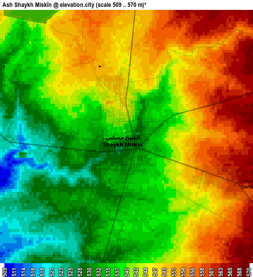
Below is the Elevation map of Ash Shaykh Miskīn, which displays elevation range with different colors. Scale of the first map is from 509 to 570 m (1670 to 1870 ft) with average elevation of 541.8 meters (=1778 ft) [note 1]
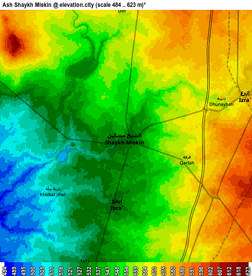
These maps also provides idea of topography and contour of this city, they are displayed at different zoom levels. More info about maps, scale and edge coordinates you can find below images.
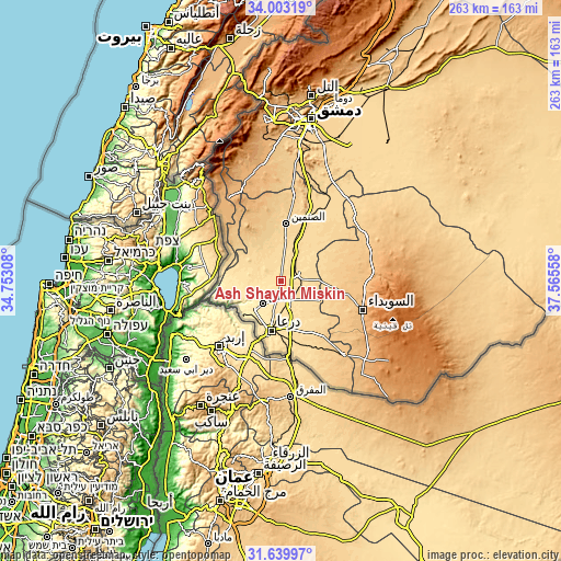
| \ | Map #1 | Map #2 | Topo.Map |
| Scale [m] | 509..570 m | 484..623 m | × |
| Scale [ft] | 1670..1870 ft | 1588..2044 ft | × |
| Average | 541.8 m = 1778 ft | 550.1 m = 1805 ft | × |
| Width | 8.21 km = 5.1 mi | 16.42 km = 10.2 mi | 262.8 km = 163.3 mi |
| Height | 8.21 km = 5.1 mi | 16.42 km = 10.2 mi | 262.8 km = 163.3 mi |
| ↑Max Latitude | 32.866359° | 32.903263° | 34.00319° |
| Latitude at center | 32.82944° | 32.82944° | 32.82944° |
| ↓Min Latitude | 32.792506° | 32.755556° | 31.63997° |
| ← Min Longitude | 36.115385° | 36.071439° | 34.75308° |
| Longitude center | 36.15933° | 36.15933° | 36.15933° |
| →Max Longitude | 36.203275° | 36.247221° | 37.56558° |
Nearby cities:
Cities around Ash Shaykh Miskīn sort by population:
• Dar‘ā elevation 489 m
24 km,  192°
192°
• Ţafas 489 m
13.4 km,  220°
220°
• Jāsim 657 m
20.3 km,  332°
332°
• Inkhil 623 m
21.2 km,  352°
352°
• Al Ḩarāk 635 m
16.7 km,  122°
122°
• Izra‘ 581 m
10 km,  62°
62°
• Ash Shajarah 419 m
26.6 km,  256°
256°
• Al Muzayrīb 447 m
18 km, 223°
• Tasīl 505 m
17.7 km,  271°
271°
• Nawá 571 m
13.1 km,  301°
301°
• Khirbat Ghazālah 566 m
11.4 km,  158°
158°
• Dā‘il 525 m
8.8 km,  198°
198°
Multilingual:
 En español:
Ash Shaykh Miskīn elevación 534 m.
 En France:
Ash Shaykh Miskīn élévation 534 m.
 Auf Deutsch:
Ash Shaykh Miskīn höhe über dem Meeresspiegel ist 534 m.

Sources and notes:
- [note 1] Map square and city borders are not equal. Map elevation data is calculated only from area inside that square.
- [src 1] Elevation data from geonames database provided with same terms of usage.
- [src 2] The elevation map of Ash Shaykh Miskīn is generated using elevation data from NASA's 3 arcsec (90m) resolution SRTM data.
- [src 3] Base (background) map © OpenStreetMap contributors tiles are generated by Geofabrik and OpenTopoMap.
Copyright & License:
This Ash Shaykh Miskīn Elevation Map is licensed under CC BY-SA. You may reuse any part from this page, if you give a proper credit by linking to this URL:
 More info on terms of use page.