Qaţanā elevation
Qaţanā (Rif-dimashq), Syria elevation is 897 meters and Qaţanā elevation in feet is 2943 ft above sea level [src 1]. Qaţanā is a seat of a second-order administrative division (feature code) with elevation that is 368 meters (1207 ft) bigger than average city elevation in Syria.
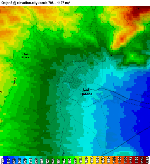
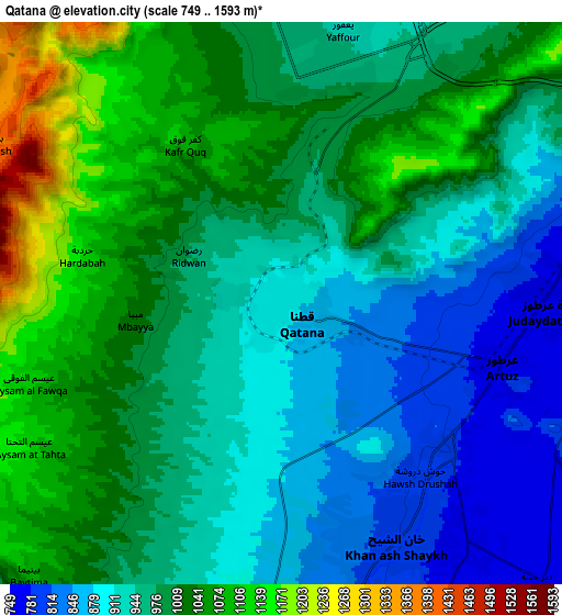
Below is the Elevation map of Qaţanā, which displays elevation range with different colors. Scale of the first map is from 798 to 1197 m (2618 to 3927 ft) with average elevation of 934 meters (=3064 ft) [note 1]
These maps also provides idea of topography and contour of this city, they are displayed at different zoom levels. More info about maps, scale and edge coordinates you can find below images.
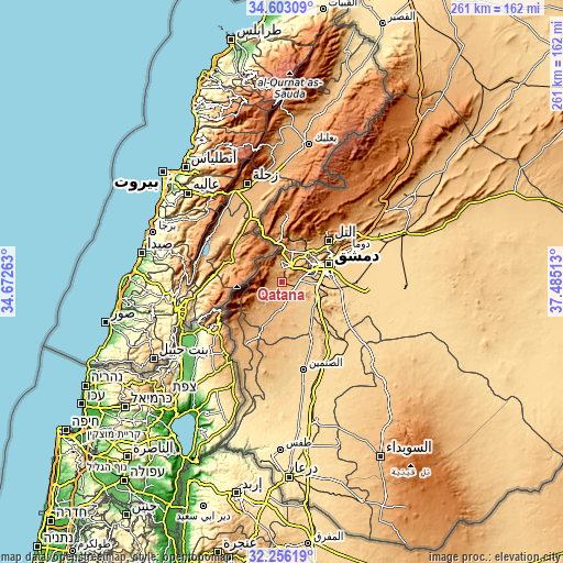
| \ | Map #1 | Map #2 | Topo.Map |
| Scale [m] | 798..1197 m | 749..1593 m | × |
| Scale [ft] | 2618..3927 ft | 2457..5226 ft | × |
| Average | 934 m = 3064 ft | 974.6 m = 3198 ft | × |
| Width | 8.15 km = 5.1 mi | 16.31 km = 10.1 mi | 261 km = 162.2 mi |
| Height | 8.16 km = 5.1 mi | 16.31 km = 10.1 mi | 261 km = 162.2 mi |
| ↑Max Latitude | 33.474234° | 33.510883° | 34.60309° |
| Latitude at center | 33.43757° | 33.43757° | 33.43757° |
| ↓Min Latitude | 33.40089° | 33.364195° | 32.25619° |
| ← Min Longitude | 36.034935° | 35.990989° | 34.67263° |
| Longitude center | 36.07888° | 36.07888° | 36.07888° |
| →Max Longitude | 36.122825° | 36.166771° | 37.48513° |
Nearby cities:
Cities around Qaţanā sort by population:
• Damascus elevation 701 m
21.3 km,  67°
67°
• Dārayyā 703 m
14.4 km,  80°
80°
• Al Kiswah 724 m
17.5 km,  120°
120°
• Jaramānā 670 m
25.4 km, 77°
• Babīlā 669 m
23.7 km, 80°
• ‘Ayn al Fījah 822 m
22 km,  25°
25°
• Al Ḩajar al Aswad 676 m
21 km, 83°
• Mazra‘at Bayt Jinn 1073 m
19 km,  230°
230°
• Sa‘sa‘ 888 m
18.2 km,  197°
197°
• Qadsayyā 791 m
17.7 km,  45°
45°
• Ad Dīmās 1109 m
16.7 km,  4°
4°
• Sahnaiya 705 m
13.7 km,  95°
95°
Multilingual:
 En español:
Qaţanā elevación 897 m.
 En France:
Qaţanā élévation 897 m.


Sources and notes:
- [note 1] Map square and city borders are not equal. Map elevation data is calculated only from area inside that square.
- [src 1] Elevation data from geonames database provided with same terms of usage.
- [src 2] The elevation map of Qaţanā is generated using elevation data from NASA's 3 arcsec (90m) resolution SRTM data.
- [src 3] Base (background) map © OpenStreetMap contributors tiles are generated by Geofabrik and OpenTopoMap.
Copyright & License:
This Qaţanā Elevation Map is licensed under CC BY-SA. You may reuse any part from this page, if you give a proper credit by linking to this URL:
 More info on terms of use page.