Tchoban Bey elevation
Tchoban Bey (Aleppo), Syria elevation is 496 meters and Tchoban Bey elevation in feet is 1627 ft above sea level [src 1]. Tchoban Bey is a seat of a third-order administrative division (feature code) with elevation that is 33 meters (108 ft) smaller than average city elevation in Syria.
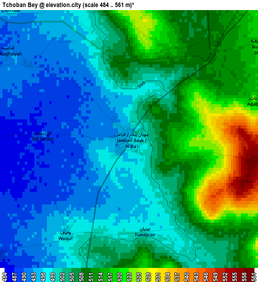
Below is the Elevation map of Tchoban Bey, which displays elevation range with different colors. Scale of the first map is from 484 to 561 m (1588 to 1841 ft) with average elevation of 503.5 meters (=1652 ft) [note 1]
These maps also provides idea of topography and contour of this city, they are displayed at different zoom levels. More info about maps, scale and edge coordinates you can find below images.
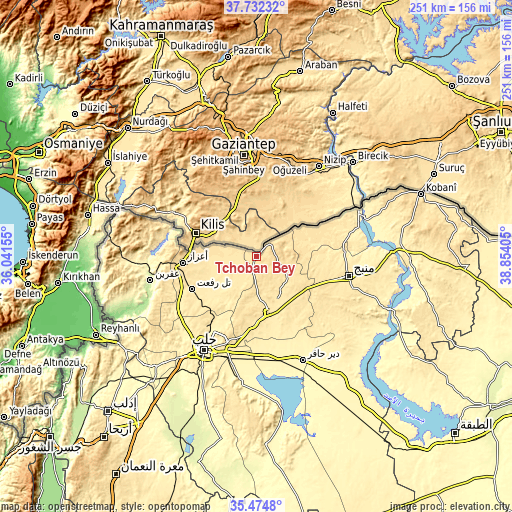
| \ | Map #1 | Topo.Map |
| Scale [m] | 484..561 m | × |
| Scale [ft] | 1588..1841 ft | × |
| Average | 503.5 m = 1652 ft | × |
| Width | 7.84 km = 4.9 mi | 251 km = 156 mi |
| Height | 7.84 km = 4.9 mi | 251 km = 156 mi |
| ↑Max Latitude | 36.647087° | 37.73232° |
| Latitude at center | 36.61182° | 36.61182° |
| ↓Min Latitude | 36.576537° | 35.4748° |
| ← Min Longitude | 37.403855° | 36.04155° |
| Longitude center | 37.4478° | 37.4478° |
| →Max Longitude | 37.491745° | 38.85405° |
Nearby cities:
Cities around Tchoban Bey sort by population:
• Al Bāb elevation 460 m
27.5 km,  167°
167°
• Manbij 468 m
46.2 km,  101°
101°
• I‘zāz 559 m
36 km,  265°
265°
• Tādif 440 m
30.2 km, 165°
• Tall Rif‘at 486 m
35.2 km,  243°
243°
• Kafr Şaghīr 464 m
39.4 km,  205°
205°
• Sharān 490 m
45.6 km, 271°
• Al ‘Arīmah 527 m
28.9 km,  122°
122°
• Māri‘ 450 m
26.6 km, 237°
• Al Ghandūrah 488 m
26.2 km,  75°
75°
• Şūrān 460 m
21.6 km,  256°
256°
• Akhtarīn 471 m
15.1 km,  221°
221°
Multilingual:
 En español:
Tchoban Bey elevación 496 m.
 En France:
Tchoban Bey élévation 496 m.
 Auf Deutsch:
Tchoban Bey höhe über dem Meeresspiegel ist 496 m.

Sources and notes:
- [note 1] Map square and city borders are not equal. Map elevation data is calculated only from area inside that square.
- [src 1] Elevation data from geonames database provided with same terms of usage.
- [src 2] The elevation map of Tchoban Bey is generated using elevation data from NASA's 3 arcsec (90m) resolution SRTM data.
- [src 3] Base (background) map © OpenStreetMap contributors tiles are generated by Geofabrik and OpenTopoMap.
Copyright & License:
This Tchoban Bey Elevation Map is licensed under CC BY-SA. You may reuse any part from this page, if you give a proper credit by linking to this URL:
 More info on terms of use page.