Tall Rif‘at elevation
Tall Rif‘at (Aleppo), Syria elevation is 486 meters and Tall Rif‘at elevation in feet is 1594 ft above sea level [src 1]. Tall Rif‘at is a seat of a third-order administrative division (feature code) with elevation that is 43 meters (141 ft) smaller than average city elevation in Syria.
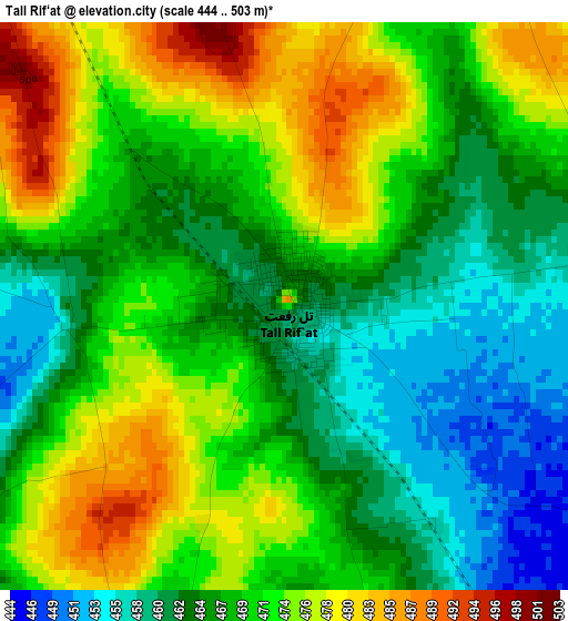
Below is the Elevation map of Tall Rif‘at, which displays elevation range with different colors. Scale of the first map is from 444 to 503 m (1457 to 1650 ft) with average elevation of 469 meters (=1539 ft) [note 1]
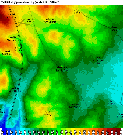
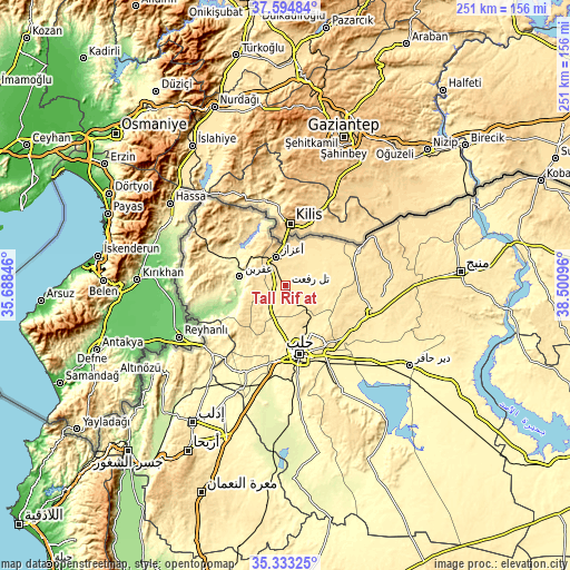
These maps also provides idea of topography and contour of this city, they are displayed at different zoom levels. More info about maps, scale and edge coordinates you can find below images.
| \ | Map #1 | Map #2 | Topo.Map |
| Scale [m] | 444..503 m | 417..546 m | × |
| Scale [ft] | 1457..1650 ft | 1368..1791 ft | × |
| Average | 469 m = 1539 ft | 470.6 m = 1544 ft | × |
| Width | 7.86 km = 4.9 mi | 15.72 km = 9.8 mi | 251.5 km = 156.3 mi |
| Height | 7.86 km = 4.9 mi | 15.72 km = 9.8 mi | 251.5 km = 156.3 mi |
| ↑Max Latitude | 36.50762° | 36.542935° | 37.59484° |
| Latitude at center | 36.47229° | 36.47229° | 36.47229° |
| ↓Min Latitude | 36.436944° | 36.401581° | 35.33325° |
| ← Min Longitude | 37.050765° | 37.006819° | 35.68846° |
| Longitude center | 37.09471° | 37.09471° | 37.09471° |
| →Max Longitude | 37.138655° | 37.182601° | 38.50096° |
Nearby cities:
Cities around Tall Rif‘at sort by population:
• Aleppo elevation 401 m
30.7 km,  168°
168°
• I‘zāz 559 m
13.4 km,  341°
341°
• ‘Afrīn 229 m
20.6 km,  282°
282°
• Nubl 413 m
13.8 km,  221°
221°
• Kafr Şaghīr 464 m
24.6 km,  144°
144°
• Al Ma‘baţlī 523 m
33 km,  287°
287°
• Dārat ‘Izzah 520 m
30.3 km,  225°
225°
• Akhtarīn 471 m
22 km,  78°
78°
• Sharān 490 m
21.9 km,  319°
319°
• Ḩuraytān 428 m
20.4 km,  182°
182°
• Şūrān 460 m
14.8 km,  45°
45°
• Māri‘ 450 m
9.2 km, 82°
Multilingual:
 En español:
Tall Rif‘at elevación 486 m.
 En France:
Tall Rif‘at élévation 486 m.
 Auf Deutsch:
Tall Rif‘at höhe über dem Meeresspiegel ist 486 m.

Sources and notes:
- [note 1] Map square and city borders are not equal. Map elevation data is calculated only from area inside that square.
- [src 1] Elevation data from geonames database provided with same terms of usage.
- [src 2] The elevation map of Tall Rif‘at is generated using elevation data from NASA's 3 arcsec (90m) resolution SRTM data.
- [src 3] Base (background) map © OpenStreetMap contributors tiles are generated by Geofabrik and OpenTopoMap.
Copyright & License:
This Tall Rif‘at Elevation Map is licensed under CC BY-SA. You may reuse any part from this page, if you give a proper credit by linking to this URL:
 More info on terms of use page.