Dārat ‘Izzah elevation
Dārat ‘Izzah (Aleppo), Syria elevation is 520 meters and Dārat ‘Izzah elevation in feet is 1706 ft above sea level [src 1]. Dārat ‘Izzah is a seat of a third-order administrative division (feature code) with elevation that is 9 meters (30 ft) smaller than average city elevation in Syria.
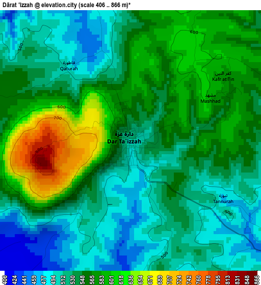
Below is the Elevation map of Dārat ‘Izzah, which displays elevation range with different colors. Scale of the first map is from 406 to 866 m (1332 to 2841 ft) with average elevation of 547.1 meters (=1795 ft) [note 1]
These maps also provides idea of topography and contour of this city, they are displayed at different zoom levels. More info about maps, scale and edge coordinates you can find below images.
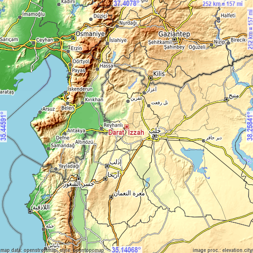
| \ | Map #1 | Topo.Map |
| Scale [m] | 406..866 m | × |
| Scale [ft] | 1332..2841 ft | × |
| Average | 547.1 m = 1795 ft | × |
| Width | 7.88 km = 4.9 mi | 252.1 km = 156.6 mi |
| Height | 7.88 km = 4.9 mi | 252.1 km = 156.6 mi |
| ↑Max Latitude | 36.317887° | 37.4078° |
| Latitude at center | 36.28247° | 36.28247° |
| ↓Min Latitude | 36.247037° | 35.14068° |
| ← Min Longitude | 36.808215° | 35.44591° |
| Longitude center | 36.85216° | 36.85216° |
| →Max Longitude | 36.896105° | 38.25841° |
Nearby cities:
Cities around Dārat ‘Izzah sort by population:
• Aleppo elevation 401 m
29.1 km,  108°
108°
• ‘Afrīn 229 m
25.6 km,  3°
3°
• Tall Rif‘at 486 m
30.3 km,  45°
45°
• Nubl 413 m
16.5 km, 49°
• Ad Dānā 400 m
10.7 km,  223°
223°
• Taftanāz 329 m
32.2 km,  190°
190°
• Ḩārim 173 m
30.7 km,  255°
255°
• Qarqania 541 m
26.8 km,  233°
233°
• Az Zarbah 272 m
26.5 km,  154°
154°
• Ḩuraytān 428 m
20.9 km,  88°
88°
• Jindayris 237 m
19.2 km,  310°
310°
• Al Atārib 311 m
16.1 km, 188°
Multilingual:
 En español:
Dārat ‘Izzah elevación 520 m.
 En France:
Dārat ‘Izzah élévation 520 m.
 Auf Deutsch:
Dārat ‘Izzah höhe über dem Meeresspiegel ist 520 m.

Sources and notes:
- [note 1] Map square and city borders are not equal. Map elevation data is calculated only from area inside that square.
- [src 1] Elevation data from geonames database provided with same terms of usage.
- [src 2] The elevation map of Dārat ‘Izzah is generated using elevation data from NASA's 3 arcsec (90m) resolution SRTM data.
- [src 3] Base (background) map © OpenStreetMap contributors tiles are generated by Geofabrik and OpenTopoMap.
Copyright & License:
This Dārat ‘Izzah Elevation Map is licensed under CC BY-SA. You may reuse any part from this page, if you give a proper credit by linking to this URL:
 More info on terms of use page.