Manbij elevation
Manbij (Aleppo, Manbij District), Syria elevation is 468 meters and Manbij elevation in feet is 1535 ft above sea level [src 1]. Manbij is a seat of a second-order administrative division (feature code) with elevation that is 61 meters (200 ft) smaller than average city elevation in Syria.
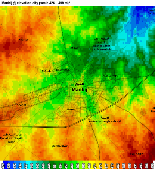
Below is the Elevation map of Manbij, which displays elevation range with different colors. Scale of the first map is from 426 to 499 m (1398 to 1637 ft) with average elevation of 467.2 meters (=1533 ft) [note 1]
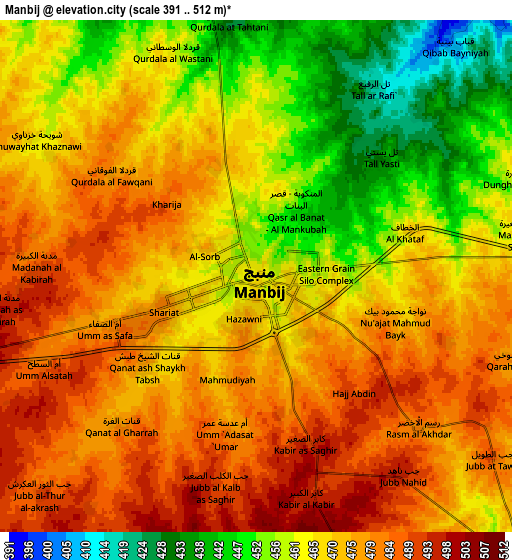
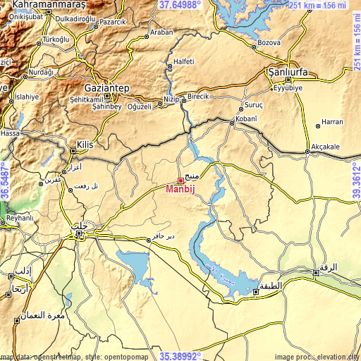
These maps also provides idea of topography and contour of this city, they are displayed at different zoom levels. More info about maps, scale and edge coordinates you can find below images.
| \ | Map #1 | Map #2 | Topo.Map |
| Scale [m] | 426..499 m | 391..512 m | × |
| Scale [ft] | 1398..1637 ft | 1283..1680 ft | × |
| Average | 467.2 m = 1533 ft | 469.7 m = 1541 ft | × |
| Width | 7.85 km = 4.9 mi | 15.71 km = 9.8 mi | 251.3 km = 156.2 mi |
| Height | 7.85 km = 4.9 mi | 15.71 km = 9.8 mi | 251.3 km = 156.2 mi |
| ↑Max Latitude | 36.563455° | 36.598744° | 37.64988° |
| Latitude at center | 36.52815° | 36.52815° | 36.52815° |
| ↓Min Latitude | 36.492829° | 36.457492° | 35.38992° |
| ← Min Longitude | 37.911005° | 37.867059° | 36.5487° |
| Longitude center | 37.95495° | 37.95495° | 37.95495° |
| →Max Longitude | 37.998895° | 38.042841° | 39.3612° |
Nearby cities:
Cities around Manbij sort by population:
• Al Bāb elevation 460 m
43 km,  245°
245°
• Tādif 440 m
42.9 km,  242°
242°
• Dayr Ḩāfir 349 m
46.8 km,  208°
208°
• Jarābulus 356 m
32.6 km,  8°
8°
• Tchoban Bey 496 m
46.2 km,  281°
281°
• Rasm al Ḩarmal 386 m
38.1 km, 214°
• Al Khafsah 355 m
33.6 km,  169°
169°
• Şirrīn ash Shamālīyah 353 m
31.4 km,  77°
77°
• Shuyūkh Taḩtānī 333 m
27 km,  23°
23°
• Al Ghandūrah 488 m
25.3 km,  308°
308°
• Al ‘Arīmah 527 m
21.8 km, 253°
• Abū Qalqal 398 m
17.8 km,  124°
124°
Multilingual:
 En español:
Manbiy elevación 468 m.
 En France:
Manbij élévation 468 m.
 Auf Deutsch:
Manbidsch höhe über dem Meeresspiegel ist 468 m.

Sources and notes:
- [note 1] Map square and city borders are not equal. Map elevation data is calculated only from area inside that square.
- [src 1] Elevation data from geonames database provided with same terms of usage.
- [src 2] The elevation map of Manbij is generated using elevation data from NASA's 3 arcsec (90m) resolution SRTM data.
- [src 3] Base (background) map © OpenStreetMap contributors tiles are generated by Geofabrik and OpenTopoMap.
Copyright & License:
This Manbij Elevation Map is licensed under CC BY-SA. You may reuse any part from this page, if you give a proper credit by linking to this URL:
 More info on terms of use page.