Sinjār elevation
Sinjār (Idlib), Syria elevation is 405 meters and Sinjār elevation in feet is 1329 ft above sea level [src 1]. Sinjār is a seat of a third-order administrative division (feature code) with elevation that is 124 meters (407 ft) smaller than average city elevation in Syria.
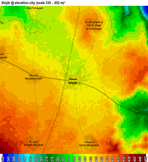
Below is the Elevation map of Sinjār, which displays elevation range with different colors. Scale of the first map is from 339 to 452 m (1112 to 1483 ft) with average elevation of 410.6 meters (=1347 ft) [note 1]
These maps also provides idea of topography and contour of this city, they are displayed at different zoom levels. More info about maps, scale and edge coordinates you can find below images.
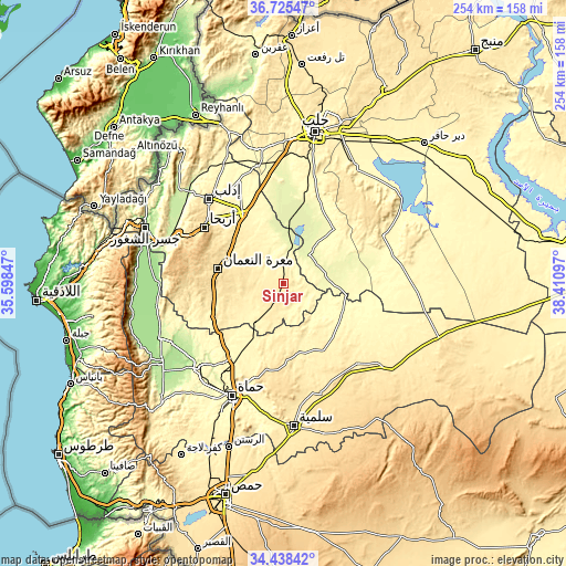
| \ | Map #1 | Topo.Map |
| Scale [m] | 339..452 m | × |
| Scale [ft] | 1112..1483 ft | × |
| Average | 410.6 m = 1347 ft | × |
| Width | 7.95 km = 4.9 mi | 254.3 km = 158 mi |
| Height | 7.95 km = 4.9 mi | 254.3 km = 158 mi |
| ↑Max Latitude | 35.625838° | 36.72547° |
| Latitude at center | 35.59011° | 35.59011° |
| ↓Min Latitude | 35.554366° | 34.43842° |
| ← Min Longitude | 36.960775° | 35.59847° |
| Longitude center | 37.00472° | 37.00472° |
| →Max Longitude | 37.048665° | 38.41097° |
Nearby cities:
Cities around Sinjār sort by population:
• Khān Shaykhūn elevation 376 m
36 km,  242°
242°
• Kafranbel 643 m
39.9 km,  273°
273°
• Sarāqib 366 m
35.4 km,  329°
329°
• Souran 356 m
40.5 km,  214°
214°
• Mūrak 374 m
37.1 km,  230°
230°
• Iḩsim 762 m
43 km,  289°
289°
• Ḩīsh 485 m
33 km,  261°
261°
• Tall aḑ Ḑamān 290 m
33 km,  42°
42°
• Al Ḩamrā’ 386 m
31.5 km,  166°
166°
• Ma‘arrat an Nu‘mān 533 m
30.3 km,  282°
282°
• At Tamāni‘ah 395 m
27.4 km, 237°
• Abū az̧ Z̧uhūr 259 m
17.1 km,  12°
12°
Multilingual:
 En español:
Sinjār elevación 405 m.
 En France:
Sinjār élévation 405 m.


Sources and notes:
- [note 1] Map square and city borders are not equal. Map elevation data is calculated only from area inside that square.
- [src 1] Elevation data from geonames database provided with same terms of usage.
- [src 2] The elevation map of Sinjār is generated using elevation data from NASA's 3 arcsec (90m) resolution SRTM data.
- [src 3] Base (background) map © OpenStreetMap contributors tiles are generated by Geofabrik and OpenTopoMap.
Copyright & License:
This Sinjār Elevation Map is licensed under CC BY-SA. You may reuse any part from this page, if you give a proper credit by linking to this URL:
 More info on terms of use page.