Sarāqib elevation
Sarāqib (Idlib), Syria elevation is 366 meters and Sarāqib elevation in feet is 1201 ft above sea level [src 1]. Sarāqib is a seat of a third-order administrative division (feature code) with elevation that is 163 meters (535 ft) smaller than average city elevation in Syria.
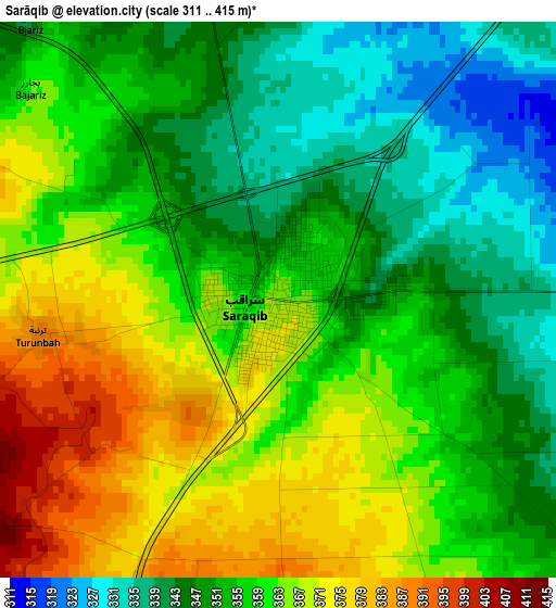
Below is the Elevation map of Sarāqib, which displays elevation range with different colors. Scale of the first map is from 311 to 415 m (1020 to 1362 ft) with average elevation of 357 meters (=1171 ft) [note 1]
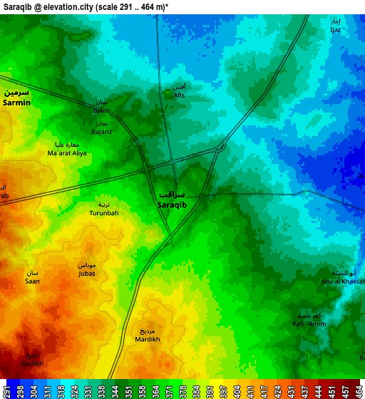
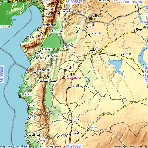
These maps also provides idea of topography and contour of this city, they are displayed at different zoom levels. More info about maps, scale and edge coordinates you can find below images.
| \ | Map #1 | Map #2 | Topo.Map |
| Scale [m] | 311..415 m | 291..464 m | × |
| Scale [ft] | 1020..1362 ft | 955..1522 ft | × |
| Average | 357 m = 1171 ft | 358.2 m = 1175 ft | × |
| Width | 7.92 km = 4.9 mi | 15.84 km = 9.8 mi | 253.4 km = 157.5 mi |
| Height | 7.92 km = 4.9 mi | 15.84 km = 9.8 mi | 253.4 km = 157.5 mi |
| ↑Max Latitude | 35.900076° | 35.935665° | 36.99587° |
| Latitude at center | 35.86447° | 35.86447° | 35.86447° |
| ↓Min Latitude | 35.828848° | 35.793211° | 34.71668° |
| ← Min Longitude | 36.761965° | 36.718019° | 35.39966° |
| Longitude center | 36.80591° | 36.80591° | 36.80591° |
| →Max Longitude | 36.849855° | 36.893801° | 38.21216° |
Nearby cities:
Cities around Sarāqib sort by population:
• Idlib elevation 442 m
17.1 km,  295°
295°
• Ma‘arratmişrīn 339 m
20.3 km,  323°
323°
• Binnish 363 m
13.2 km, 321°
• Al Atārib 311 m
30.6 km,  3°
3°
• Iḩsim 762 m
27.6 km,  234°
234°
• Az Zarbah 272 m
27.5 km,  34°
34°
• Ma‘arrat an Nu‘mān 533 m
26.7 km,  205°
205°
• Al Ḩāḑir 280 m
26.1 km,  57°
57°
• Abū az̧ Z̧uhūr 259 m
25.6 km,  122°
122°
• Arīḩā 598 m
18.6 km,  252°
252°
• Taftanāz 329 m
15 km,  353°
353°
• Sarmīn 390 m
8.5 km, 301°
Multilingual:
 En español:
Sarāqib elevación 366 m.
 En France:
Sarāqib élévation 366 m.


Sources and notes:
- [note 1] Map square and city borders are not equal. Map elevation data is calculated only from area inside that square.
- [src 1] Elevation data from geonames database provided with same terms of usage.
- [src 2] The elevation map of Sarāqib is generated using elevation data from NASA's 3 arcsec (90m) resolution SRTM data.
- [src 3] Base (background) map © OpenStreetMap contributors tiles are generated by Geofabrik and OpenTopoMap.
Copyright & License:
This Sarāqib Elevation Map is licensed under CC BY-SA. You may reuse any part from this page, if you give a proper credit by linking to this URL:
 More info on terms of use page.