Abū az̧ Z̧uhūr elevation
Abū az̧ Z̧uhūr (Idlib), Syria elevation is 259 meters and Abū az̧ Z̧uhūr elevation in feet is 850 ft above sea level [src 1]. Abū az̧ Z̧uhūr is a seat of a third-order administrative division (feature code) with elevation that is 270 meters (886 ft) smaller than average city elevation in Syria.
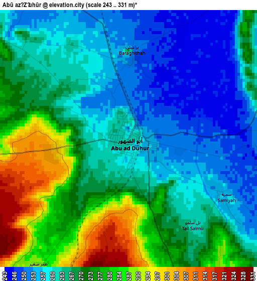
Below is the Elevation map of Abū az̧ Z̧uhūr, which displays elevation range with different colors. Scale of the first map is from 243 to 331 m (797 to 1086 ft) with average elevation of 267.8 meters (=879 ft) [note 1]
These maps also provides idea of topography and contour of this city, they are displayed at different zoom levels. More info about maps, scale and edge coordinates you can find below images.
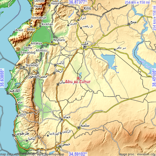
| \ | Map #1 | Topo.Map |
| Scale [m] | 243..331 m | × |
| Scale [ft] | 797..1086 ft | × |
| Average | 267.8 m = 879 ft | × |
| Width | 7.93 km = 4.9 mi | 253.8 km = 157.7 mi |
| Height | 7.93 km = 4.9 mi | 253.8 km = 157.7 mi |
| ↑Max Latitude | 35.776241° | 36.87377° |
| Latitude at center | 35.74058° | 35.74058° |
| ↓Min Latitude | 35.704903° | 34.59102° |
| ← Min Longitude | 37.000855° | 35.63855° |
| Longitude center | 37.0448° | 37.0448° |
| →Max Longitude | 37.088745° | 38.45105° |
Nearby cities:
Cities around Abū az̧ Z̧uhūr sort by population:
• Sarāqib elevation 366 m
25.6 km,  302°
302°
• Binnish 363 m
38.3 km,  308°
308°
• Arīḩā 598 m
40.1 km,  281°
281°
• Taftanāz 329 m
37 km,  320°
320°
• Az Zarbah 272 m
36.8 km,  350°
350°
• Ma‘arrat an Nu‘mān 533 m
34.8 km,  252°
252°
• Banān 491 m
34.8 km,  41°
41°
• Al Ḩājib 579 m
34.6 km,  66°
66°
• Sarmīn 390 m
34.1 km, 302°
• Al Ḩāḑir 280 m
27.8 km,  1°
1°
• Tall aḑ Ḑamān 290 m
20.3 km, 68°
• Sinjār 405 m
17.1 km,  192°
192°
Multilingual:
 En español:
Abū az̧ Z̧uhūr elevación 259 m.
 En France:
Abū az̧ Z̧uhūr élévation 259 m.
 Auf Deutsch:
Abū az̧ Z̧uhūr höhe über dem Meeresspiegel ist 259 m.

Sources and notes:
- [note 1] Map square and city borders are not equal. Map elevation data is calculated only from area inside that square.
- [src 1] Elevation data from geonames database provided with same terms of usage.
- [src 2] The elevation map of Abū az̧ Z̧uhūr is generated using elevation data from NASA's 3 arcsec (90m) resolution SRTM data.
- [src 3] Base (background) map © OpenStreetMap contributors tiles are generated by Geofabrik and OpenTopoMap.
Copyright & License:
This Abū az̧ Z̧uhūr Elevation Map is licensed under CC BY-SA. You may reuse any part from this page, if you give a proper credit by linking to this URL:
 More info on terms of use page.