Kafranbel elevation
Kafranbel (Idlib, Maarrat al-Nu'man District), Syria elevation is 643 meters and Kafranbel elevation in feet is 2110 ft above sea level [src 1]. Kafranbel is a seat of a third-order administrative division (feature code) with elevation that is 114 meters (374 ft) bigger than average city elevation in Syria.
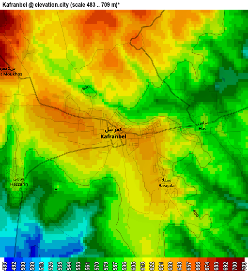
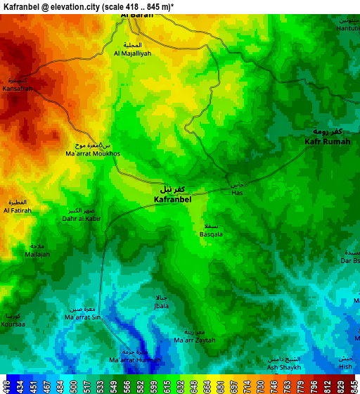
Below is the Elevation map of Kafranbel, which displays elevation range with different colors. Scale of the first map is from 483 to 709 m (1585 to 2326 ft) with average elevation of 601.3 meters (=1973 ft) [note 1]
These maps also provides idea of topography and contour of this city, they are displayed at different zoom levels. More info about maps, scale and edge coordinates you can find below images.
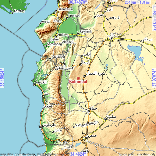
| \ | Map #1 | Map #2 | Topo.Map |
| Scale [m] | 483..709 m | 418..845 m | × |
| Scale [ft] | 1585..2326 ft | 1371..2772 ft | × |
| Average | 601.3 m = 1973 ft | 598.1 m = 1962 ft | × |
| Width | 7.94 km = 4.9 mi | 15.89 km = 9.9 mi | 254.2 km = 158 mi |
| Height | 7.94 km = 4.9 mi | 15.89 km = 9.9 mi | 254.2 km = 158 mi |
| ↑Max Latitude | 35.649478° | 35.68518° | 36.74878° |
| Latitude at center | 35.61376° | 35.61376° | 35.61376° |
| ↓Min Latitude | 35.578026° | 35.542276° | 34.4624° |
| ← Min Longitude | 36.520545° | 36.476599° | 35.15824° |
| Longitude center | 36.56449° | 36.56449° | 36.56449° |
| →Max Longitude | 36.608435° | 36.652381° | 37.97074° |
Nearby cities:
Cities around Kafranbel sort by population:
• Khān Shaykhūn elevation 376 m
20.6 km,  157°
157°
• Kafr Zaytā 316 m
26.9 km,  172°
172°
• Mūrak 374 m
28.7 km, 156°
• Qal‘at al Maḑīq 177 m
27.1 km,  215°
215°
• Kurnāz 241 m
25.9 km,  195°
195°
• At Tamāni‘ah 395 m
24 km,  136°
136°
• Arīḩā 598 m
22.6 km,  10°
10°
• Az Ziyārah 172 m
21.9 km,  291°
291°
• Muḩambal 370 m
21 km,  336°
336°
• Iḩsim 762 m
11.9 km,  356°
356°
• Ma‘arrat an Nu‘mān 533 m
10.9 km,  69°
69°
• Ḩīsh 485 m
10.2 km, 135°
Multilingual:
 En español:
Kafranbel elevación 643 m.
 En France:
Kafranbel élévation 643 m.
 Auf Deutsch:
Kafranbel höhe über dem Meeresspiegel ist 643 m.

Sources and notes:
- [note 1] Map square and city borders are not equal. Map elevation data is calculated only from area inside that square.
- [src 1] Elevation data from geonames database provided with same terms of usage.
- [src 2] The elevation map of Kafranbel is generated using elevation data from NASA's 3 arcsec (90m) resolution SRTM data.
- [src 3] Base (background) map © OpenStreetMap contributors tiles are generated by Geofabrik and OpenTopoMap.
Copyright & License:
This Kafranbel Elevation Map is licensed under CC BY-SA. You may reuse any part from this page, if you give a proper credit by linking to this URL:
 More info on terms of use page.