Tall Salḩab elevation
Tall Salḩab (Hama), Syria elevation is 196 meters and Tall Salḩab elevation in feet is 643 ft above sea level [src 1]. Tall Salḩab is a seat of a third-order administrative division (feature code) with elevation that is 333 meters (1093 ft) smaller than average city elevation in Syria.
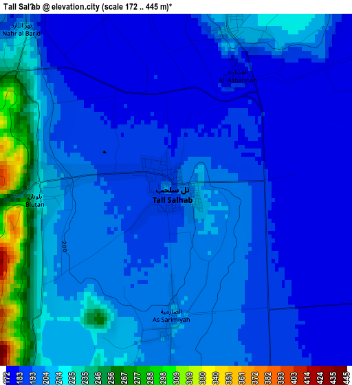
Below is the Elevation map of Tall Salḩab, which displays elevation range with different colors. Scale of the first map is from 172 to 445 m (564 to 1460 ft) with average elevation of 199.6 meters (=655 ft) [note 1]
These maps also provides idea of topography and contour of this city, they are displayed at different zoom levels. More info about maps, scale and edge coordinates you can find below images.
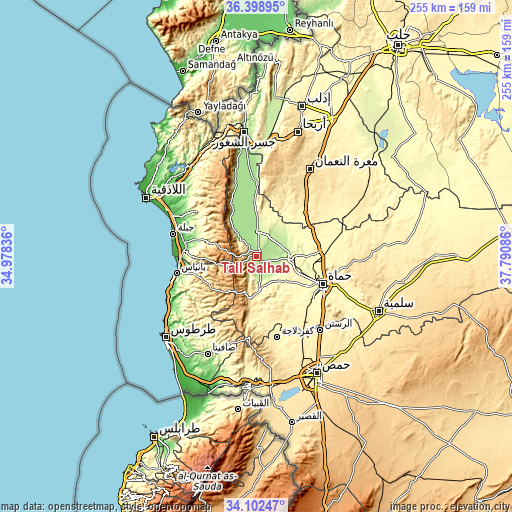
| \ | Map #1 | Topo.Map |
| Scale [m] | 172..445 m | × |
| Scale [ft] | 564..1460 ft | × |
| Average | 199.6 m = 655 ft | × |
| Width | 7.98 km = 5 mi | 255.3 km = 158.6 mi |
| Height | 7.98 km = 5 mi | 255.3 km = 158.6 mi |
| ↑Max Latitude | 35.294716° | 36.39895° |
| Latitude at center | 35.25884° | 35.25884° |
| ↓Min Latitude | 35.222948° | 34.10247° |
| ← Min Longitude | 36.340665° | 34.97836° |
| Longitude center | 36.38461° | 36.38461° |
| →Max Longitude | 36.428555° | 37.79086° |
Nearby cities:
Cities around Tall Salḩab sort by population:
• Maşyāf elevation 502 m
21.9 km,  190°
190°
• Ḩalfāyā 301 m
20.1 km,  89°
89°
• Kafr Zaytā 316 m
23.6 km,  57°
57°
• Tremseh 195 m
10.9 km,  82°
82°
• Kaff al-Jaa 891 m
25.1 km,  220°
220°
• Ad Dālīyah 879 m
22 km,  263°
263°
• Aţ Ţawāḩīn 958 m
21.3 km,  226°
226°
• Kurnāz 241 m
17.3 km,  32°
32°
• Qal‘at al Maḑīq 177 m
17.3 km,  1°
1°
• Muḩradah 268 m
17.1 km, 94°
• As Suqaylibīyah 212 m
12 km, 3°
• Jubb Ramlah 190 m
6.9 km,  142°
142°
Multilingual:
 En español:
Tall Salḩab elevación 196 m.
 En France:
Tall Salḩab élévation 196 m.
 Auf Deutsch:
Tall Salḩab höhe über dem Meeresspiegel ist 196 m.

Sources and notes:
- [note 1] Map square and city borders are not equal. Map elevation data is calculated only from area inside that square.
- [src 1] Elevation data from geonames database provided with same terms of usage.
- [src 2] The elevation map of Tall Salḩab is generated using elevation data from NASA's 3 arcsec (90m) resolution SRTM data.
- [src 3] Base (background) map © OpenStreetMap contributors tiles are generated by Geofabrik and OpenTopoMap.
Copyright & License:
This Tall Salḩab Elevation Map is licensed under CC BY-SA. You may reuse any part from this page, if you give a proper credit by linking to this URL:
 More info on terms of use page.