As Suqaylibīyah elevation
As Suqaylibīyah (Hama), Syria elevation is 212 meters and As Suqaylibīyah elevation in feet is 696 ft above sea level [src 1]. As Suqaylibīyah is a seat of a second-order administrative division (feature code) with elevation that is 317 meters (1040 ft) smaller than average city elevation in Syria.
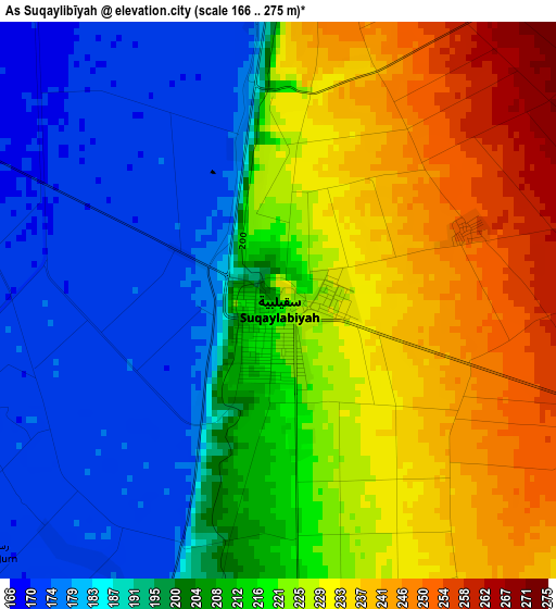
Below is the Elevation map of As Suqaylibīyah, which displays elevation range with different colors. Scale of the first map is from 166 to 275 m (545 to 902 ft) with average elevation of 210.3 meters (=690 ft) [note 1]
These maps also provides idea of topography and contour of this city, they are displayed at different zoom levels. More info about maps, scale and edge coordinates you can find below images.
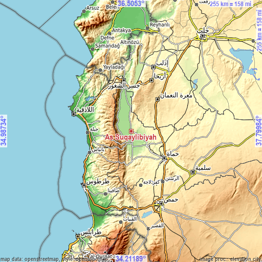
| \ | Map #1 | Topo.Map |
| Scale [m] | 166..275 m | × |
| Scale [ft] | 545..902 ft | × |
| Average | 210.3 m = 690 ft | × |
| Width | 7.97 km = 5 mi | 255 km = 158.4 mi |
| Height | 7.97 km = 5 mi | 255 km = 158.4 mi |
| ↑Max Latitude | 35.402568° | 36.5053° |
| Latitude at center | 35.36674° | 35.36674° |
| ↓Min Latitude | 35.330896° | 34.21189° |
| ← Min Longitude | 36.349645° | 34.98734° |
| Longitude center | 36.39359° | 36.39359° |
| →Max Longitude | 36.437535° | 37.79984° |
Nearby cities:
Cities around As Suqaylibīyah sort by population:
• Khān Shaykhūn elevation 376 m
24.8 km,  70°
70°
• Ḩalfāyā 301 m
22.6 km,  121°
121°
• Kafr Zaytā 316 m
19 km,  87°
87°
• Tremseh 195 m
14.5 km,  136°
136°
• Jawbat Burghāl 846 m
24.1 km,  304°
304°
• Ḩarf al Musaytirah 751 m
23.6 km,  275°
275°
• Muḩradah 268 m
20.9 km,  129°
129°
• Shaţḩah 207 m
20.5 km,  318°
318°
• Jubb Ramlah 190 m
17.8 km,  169°
169°
• Tall Salḩab 196 m
12 km,  183°
183°
• Kurnāz 241 m
8.9 km, 73°
• Qal‘at al Maḑīq 177 m
5.3 km,  357°
357°
Multilingual:
 En español:
As Suqaylibīyah elevación 212 m.
 En France:
As Suqaylibīyah élévation 212 m.
 Auf Deutsch:
As Suqaylibīyah höhe über dem Meeresspiegel ist 212 m.

Sources and notes:
- [note 1] Map square and city borders are not equal. Map elevation data is calculated only from area inside that square.
- [src 1] Elevation data from geonames database provided with same terms of usage.
- [src 2] The elevation map of As Suqaylibīyah is generated using elevation data from NASA's 3 arcsec (90m) resolution SRTM data.
- [src 3] Base (background) map © OpenStreetMap contributors tiles are generated by Geofabrik and OpenTopoMap.
Copyright & License:
This As Suqaylibīyah Elevation Map is licensed under CC BY-SA. You may reuse any part from this page, if you give a proper credit by linking to this URL:
 More info on terms of use page.