Tremseh elevation
Tremseh (Hama), Syria elevation is 195 meters and Tremseh elevation in feet is 640 ft above sea level [src 1]. Tremseh is a populated place (feature code) with elevation that is 334 meters (1096 ft) smaller than average city elevation in Syria.
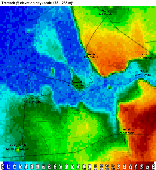
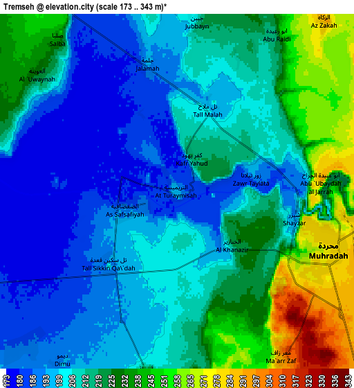
Below is the Elevation map of Tremseh, which displays elevation range with different colors. Scale of the first map is from 175 to 233 m (574 to 764 ft) with average elevation of 195.5 meters (=641 ft) [note 1]
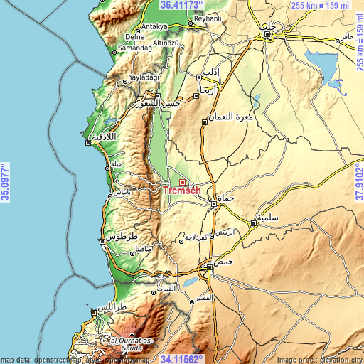
These maps also provides idea of topography and contour of this city, they are displayed at different zoom levels. More info about maps, scale and edge coordinates you can find below images.
| \ | Map #1 | Map #2 | Topo.Map |
| Scale [m] | 175..233 m | 173..343 m | × |
| Scale [ft] | 574..764 ft | 568..1125 ft | × |
| Average | 195.5 m = 641 ft | 213 m = 699 ft | × |
| Width | 7.98 km = 5 mi | 15.96 km = 9.9 mi | 255.3 km = 158.6 mi |
| Height | 7.98 km = 5 mi | 15.96 km = 9.9 mi | 255.3 km = 158.6 mi |
| ↑Max Latitude | 35.30768° | 35.343534° | 36.41173° |
| Latitude at center | 35.27181° | 35.27181° | 35.27181° |
| ↓Min Latitude | 35.235924° | 35.200022° | 34.11562° |
| ← Min Longitude | 36.460005° | 36.416059° | 35.0977° |
| Longitude center | 36.50395° | 36.50395° | 36.50395° |
| →Max Longitude | 36.547895° | 36.591841° | 37.9102° |
Nearby cities:
Cities around Tremseh sort by population:
• Khān Shaykhūn elevation 376 m
23.2 km,  35°
35°
• Souran 356 m
22.3 km,  84°
84°
• Ţayyibat al Imām 343 m
18.9 km,  91°
91°
• Ḩalfāyā 301 m
9.3 km,  97°
97°
• Kafr Zaytā 316 m
14.5 km, 38°
• Mūrak 374 m
20.5 km,  55°
55°
• Qal‘at al Maḑīq 177 m
18.9 km,  327°
327°
• As Suqaylibīyah 212 m
14.5 km,  316°
316°
• Kurnāz 241 m
13.2 km,  353°
353°
• Tall Salḩab 196 m
10.9 km,  262°
262°
• Jubb Ramlah 190 m
9.6 km,  223°
223°
• Muḩradah 268 m
6.8 km,  113°
113°
Multilingual:
 En español:
Tremseh elevación 195 m.
 En France:
Tremseh élévation 195 m.


Sources and notes:
- [note 1] Map square and city borders are not equal. Map elevation data is calculated only from area inside that square.
- [src 1] Elevation data from geonames database provided with same terms of usage.
- [src 2] The elevation map of Tremseh is generated using elevation data from NASA's 3 arcsec (90m) resolution SRTM data.
- [src 3] Base (background) map © OpenStreetMap contributors tiles are generated by Geofabrik and OpenTopoMap.
Copyright & License:
This Tremseh Elevation Map is licensed under CC BY-SA. You may reuse any part from this page, if you give a proper credit by linking to this URL:
 More info on terms of use page.