Maşyāf elevation
Maşyāf (Hama), Syria elevation is 502 meters and Maşyāf elevation in feet is 1647 ft above sea level [src 1]. Maşyāf is a seat of a second-order administrative division (feature code) with elevation that is 27 meters (89 ft) smaller than average city elevation in Syria.
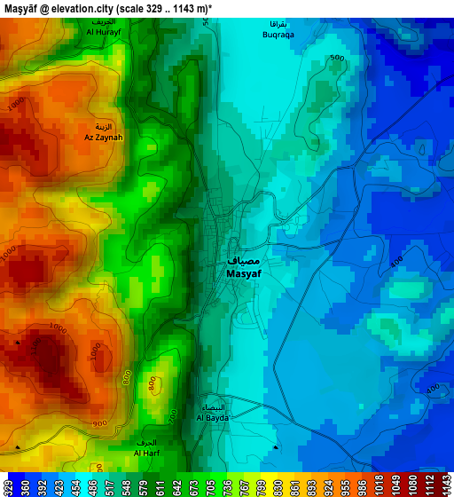
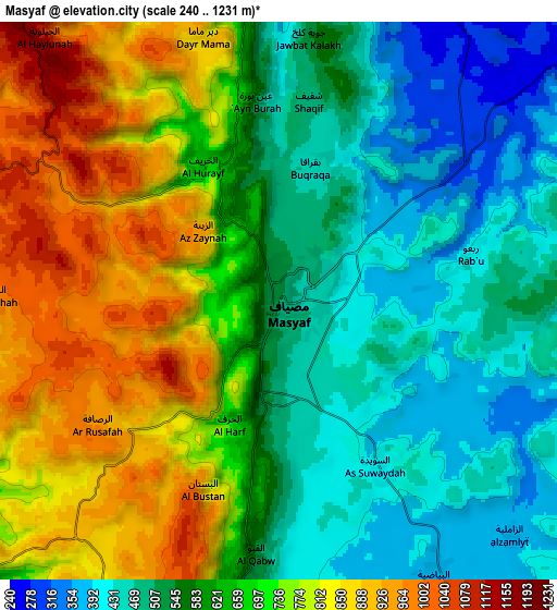
Below is the Elevation map of Maşyāf, which displays elevation range with different colors. Scale of the first map is from 329 to 1143 m (1079 to 3750 ft) with average elevation of 605.2 meters (=1986 ft) [note 1]
These maps also provides idea of topography and contour of this city, they are displayed at different zoom levels. More info about maps, scale and edge coordinates you can find below images.
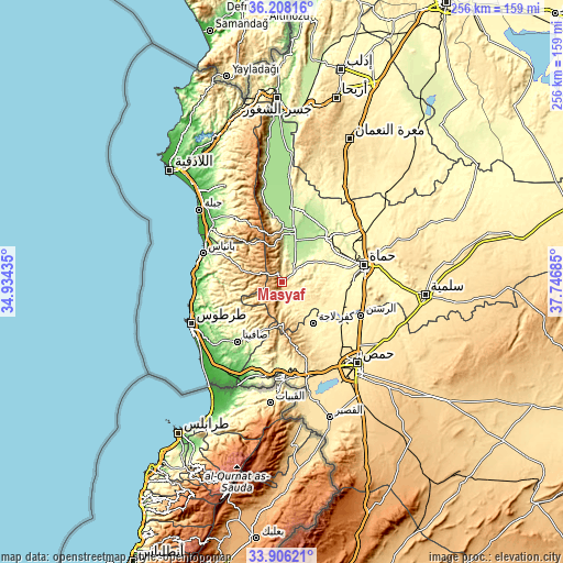
| \ | Map #1 | Map #2 | Topo.Map |
| Scale [m] | 329..1143 m | 240..1231 m | × |
| Scale [ft] | 1079..3750 ft | 787..4039 ft | × |
| Average | 605.2 m = 1986 ft | 638.8 m = 2096 ft | × |
| Width | 8 km = 5 mi | 16 km = 9.9 mi | 256 km = 159.1 mi |
| Height | 8 km = 5 mi | 16 km = 9.9 mi | 256 km = 159.1 mi |
| ↑Max Latitude | 35.101261° | 35.137207° | 36.20816° |
| Latitude at center | 35.0653° | 35.0653° | 35.0653° |
| ↓Min Latitude | 35.029323° | 34.99333° | 33.90621° |
| ← Min Longitude | 36.296655° | 36.252709° | 34.93435° |
| Longitude center | 36.3406° | 36.3406° | 36.3406° |
| →Max Longitude | 36.384545° | 36.428491° | 37.74685° |
Nearby cities:
Cities around Maşyāf sort by population:
• Kaff al-Jaa elevation 891 m
12.5 km,  280°
280°
• Mashtá al Ḩulw 502 m
22.7 km,  201°
201°
• Tall Salḩab 196 m
21.9 km,  10°
10°
• Sabbah 643 m
20.4 km,  207°
207°
• Duwayr Raslān 583 m
19.4 km,  228°
228°
• ‘Awaj 611 m
18.5 km,  161°
161°
• Jubb Ramlah 190 m
18 km,  27°
27°
• Al Qadmūs 908 m
16.9 km, 282°
• Brummānat al Mashāyikh 694 m
16.3 km,  251°
251°
• Wādī al ‘Uyūn 574 m
15.7 km,  243°
243°
• ‘Ayn Ḩalāqīm 596 m
14 km,  186°
186°
• Aţ Ţawāḩīn 958 m
13.4 km,  301°
301°
Multilingual:
 En español:
Maşyāf elevación 502 m.
 En France:
Maşyāf élévation 502 m.


Sources and notes:
- [note 1] Map square and city borders are not equal. Map elevation data is calculated only from area inside that square.
- [src 1] Elevation data from geonames database provided with same terms of usage.
- [src 2] The elevation map of Maşyāf is generated using elevation data from NASA's 3 arcsec (90m) resolution SRTM data.
- [src 3] Base (background) map © OpenStreetMap contributors tiles are generated by Geofabrik and OpenTopoMap.
Copyright & License:
This Maşyāf Elevation Map is licensed under CC BY-SA. You may reuse any part from this page, if you give a proper credit by linking to this URL:
 More info on terms of use page.