Baardheere elevation
Baardheere (Gedo), Somalia elevation is 97 meters and Baardheere elevation in feet is 318 ft above sea level [src 1]. Baardheere is a populated locality (feature code) with elevation that is 193 meters (633 ft) smaller than average city elevation in Somalia.
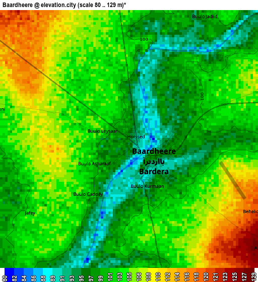
Below is the Elevation map of Baardheere, which displays elevation range with different colors. Scale of the first map is from 80 to 129 m (262 to 423 ft) with average elevation of 102.3 meters (=336 ft) [note 1]
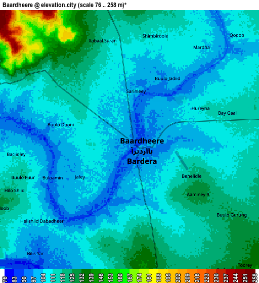
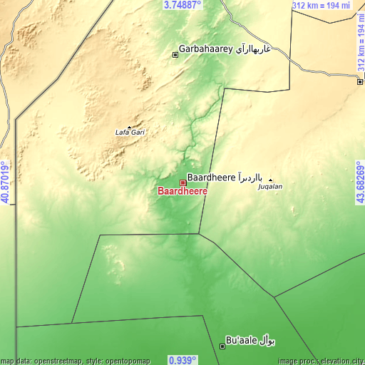
These maps also provides idea of topography and contour of this city, they are displayed at different zoom levels. More info about maps, scale and edge coordinates you can find below images.
| \ | Map #1 | Map #2 | Topo.Map |
| Scale [m] | 80..129 m | 76..258 m | × |
| Scale [ft] | 262..423 ft | 249..846 ft | × |
| Average | 102.3 m = 336 ft | 112.4 m = 369 ft | × |
| Width | 9.76 km = 6.1 mi | 19.53 km = 12.1 mi | 312.4 km = 194.1 mi |
| Height | 9.76 km = 6.1 mi | 19.53 km = 12.1 mi | 312.5 km = 194.2 mi |
| ↑Max Latitude | 2.388548° | 2.432454° | 3.74887° |
| Latitude at center | 2.34464° | 2.34464° | 2.34464° |
| ↓Min Latitude | 2.300731° | 2.25682° | 0.939° |
| ← Min Longitude | 42.232495° | 42.188549° | 40.87019° |
| Longitude center | 42.27644° | 42.27644° | 42.27644° |
| →Max Longitude | 42.320385° | 42.364331° | 43.68269° |
Nearby cities:
Cities around Baardheere sort by population:
• Jamaame elevation 12 m
258.3 km,  168°
168°
• Baidoa 441 m
174.9 km,  60°
60°
• Qoryooley 69 m
257.9 km,  103°
103°
• Jilib 25 m
214 km,  164°
164°
• Luuq 150 m
164.9 km,  10°
10°
• Buurhakaba 277 m
206.5 km,  75°
75°
• Garbahaarrey 222 m
109.6 km,  356°
356°
• Yeed 355 m
259.2 km,  18°
18°
• Saacow 63 m
81.8 km, 167°
• Waajid 381 m
195.3 km,  33°
33°
• Dujuuma 57 m
125.8 km, 164°
• Bu’aale 44 m
144.3 km, 166°
Multilingual:
 En español:
Baardheere elevación 97 m.
 En France:
Baardheere élévation 97 m.
 Auf Deutsch:
Baardheere höhe über dem Meeresspiegel ist 97 m.

Sources and notes:
- [note 1] Map square and city borders are not equal. Map elevation data is calculated only from area inside that square.
- [src 1] Elevation data from geonames database provided with same terms of usage.
- [src 2] The elevation map of Baardheere is generated using elevation data from NASA's 3 arcsec (90m) resolution SRTM data.
- [src 3] Base (background) map © OpenStreetMap contributors tiles are generated by Geofabrik and OpenTopoMap.
Copyright & License:
This Baardheere Elevation Map is licensed under CC BY-SA. You may reuse any part from this page, if you give a proper credit by linking to this URL:
 More info on terms of use page.