Garbahaarrey elevation
Garbahaarrey (Gedo), Somalia elevation is 222 meters and Garbahaarrey elevation in feet is 728 ft above sea level [src 1]. Garbahaarrey is a seat of a first-order administrative division (feature code) with elevation that is 68 meters (223 ft) smaller than average city elevation in Somalia.
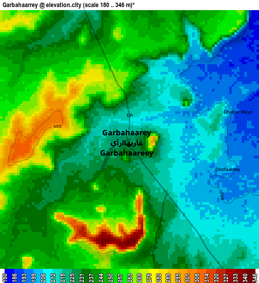
Below is the Elevation map of Garbahaarrey, which displays elevation range with different colors. Scale of the first map is from 180 to 346 m (591 to 1135 ft) with average elevation of 235.3 meters (=772 ft) [note 1]
These maps also provides idea of topography and contour of this city, they are displayed at different zoom levels. More info about maps, scale and edge coordinates you can find below images.
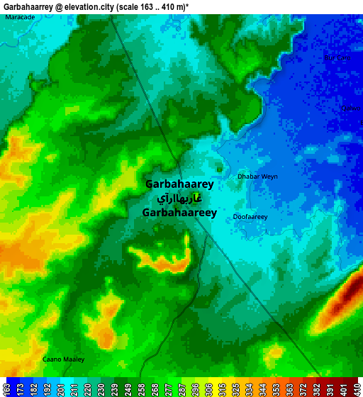
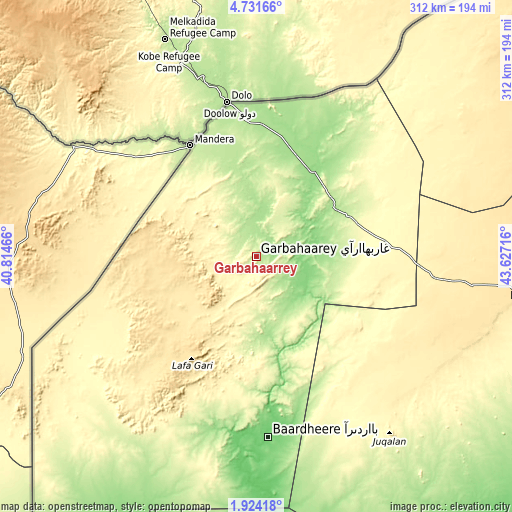
| \ | Map #1 | Map #2 | Topo.Map |
| Scale [m] | 180..346 m | 163..410 m | × |
| Scale [ft] | 591..1135 ft | 535..1345 ft | × |
| Average | 235.3 m = 772 ft | 240.3 m = 788 ft | × |
| Width | 9.76 km = 6.1 mi | 19.51 km = 12.1 mi | 312.2 km = 194 mi |
| Height | 9.76 km = 6.1 mi | 19.51 km = 12.1 mi | 312.2 km = 194 mi |
| ↑Max Latitude | 3.37279° | 3.416658° | 4.73166° |
| Latitude at center | 3.32892° | 3.32892° | 3.32892° |
| ↓Min Latitude | 3.285048° | 3.241174° | 1.92418° |
| ← Min Longitude | 42.176965° | 42.133019° | 40.81466° |
| Longitude center | 42.22091° | 42.22091° | 42.22091° |
| →Max Longitude | 42.264855° | 42.308801° | 43.62716° |
Nearby cities:
Cities around Garbahaarrey sort by population:
• Baidoa elevation 441 m
160.4 km,  98°
98°
• Baardheere 97 m
109.6 km,  176°
176°
• Luuq 150 m
63.8 km,  34°
34°
• Buurhakaba 277 m
214.3 km,  105°
105°
• Wanlaweyn 93 m
307.1 km, 104°
• Xuddur 493 m
205 km,  64°
64°
• Yeed 355 m
163 km, 33°
• Saacow 63 m
190.7 km,  172°
172°
• Waajid 381 m
125.7 km, 64°
• Dujuuma 57 m
234.1 km, 170°
• Tayeeglow 410 m
265.5 km,  73°
73°
• Bu’aale 44 m
252.9 km, 170°
Multilingual:
 En español:
Garbahaarrey elevación 222 m.
 En France:
Garbahaarrey élévation 222 m.
 Auf Deutsch:
Garbahaarrey höhe über dem Meeresspiegel ist 222 m.

Sources and notes:
- [note 1] Map square and city borders are not equal. Map elevation data is calculated only from area inside that square.
- [src 1] Elevation data from geonames database provided with same terms of usage.
- [src 2] The elevation map of Garbahaarrey is generated using elevation data from NASA's 3 arcsec (90m) resolution SRTM data.
- [src 3] Base (background) map © OpenStreetMap contributors tiles are generated by Geofabrik and OpenTopoMap.
Copyright & License:
This Garbahaarrey Elevation Map is licensed under CC BY-SA. You may reuse any part from this page, if you give a proper credit by linking to this URL:
 More info on terms of use page.