Buurhakaba elevation
Buurhakaba (Bay), Somalia elevation is 277 meters and Buurhakaba elevation in feet is 909 ft above sea level [src 1]. Buurhakaba is a seat of a second-order administrative division (feature code) with elevation that is 13 meters (43 ft) smaller than average city elevation in Somalia.
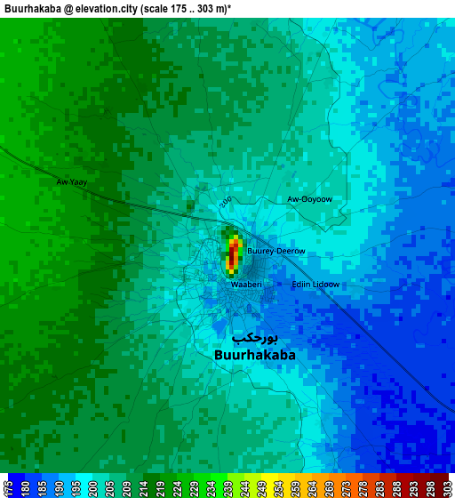
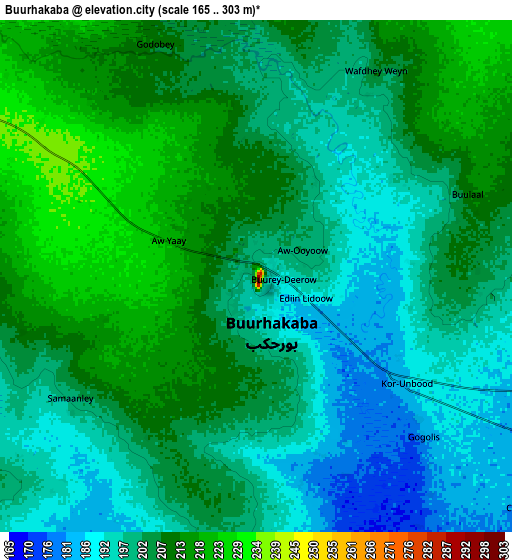
Below is the Elevation map of Buurhakaba, which displays elevation range with different colors. Scale of the first map is from 175 to 303 m (574 to 994 ft) with average elevation of 203.9 meters (=669 ft) [note 1]
These maps also provides idea of topography and contour of this city, they are displayed at different zoom levels. More info about maps, scale and edge coordinates you can find below images.
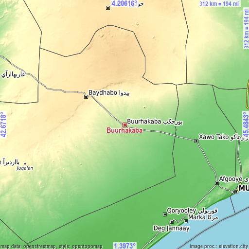
| \ | Map #1 | Map #2 | Topo.Map |
| Scale [m] | 175..303 m | 165..303 m | × |
| Scale [ft] | 574..994 ft | 541..994 ft | × |
| Average | 203.9 m = 669 ft | 203.6 m = 668 ft | × |
| Width | 9.76 km = 6.1 mi | 19.52 km = 12.1 mi | 312.3 km = 194.1 mi |
| Height | 9.76 km = 6.1 mi | 19.52 km = 12.1 mi | 312.3 km = 194.1 mi |
| ↑Max Latitude | 2.846462° | 2.890352° | 4.20616° |
| Latitude at center | 2.80257° | 2.80257° | 2.80257° |
| ↓Min Latitude | 2.758676° | 2.714781° | 1.3973° |
| ← Min Longitude | 44.034105° | 43.990159° | 42.6718° |
| Longitude center | 44.07805° | 44.07805° | 44.07805° |
| →Max Longitude | 44.121995° | 44.165941° | 45.4843° |
Nearby cities:
Cities around Buurhakaba sort by population:
• Mogadishu elevation 12 m
164.4 km,  121°
121°
• Marka 12 m
143.3 km,  147°
147°
• Baidoa 441 m
58.8 km,  306°
306°
• Afgooye 87 m
137.4 km, 122°
• Qoryooley 69 m
123.5 km,  156°
156°
• Jawhar 108 m
158 km,  90°
90°
• Wanlaweyn 93 m
92.9 km,  102°
102°
• Xuddur 493 m
148.1 km,  351°
351°
• Jalalaqsi 129 m
180.6 km,  69°
69°
• Mahaddayweyne 114 m
162.9 km,  83°
83°
• Waajid 381 m
145.1 km,  320°
320°
• Tayeeglow 410 m
143.5 km,  19°
19°
Multilingual:
 En español:
Buurhakaba elevación 277 m.
 En France:
Buurhakaba élévation 277 m.
 Auf Deutsch:
Buurhakaba höhe über dem Meeresspiegel ist 277 m.

Sources and notes:
- [note 1] Map square and city borders are not equal. Map elevation data is calculated only from area inside that square.
- [src 1] Elevation data from geonames database provided with same terms of usage.
- [src 2] The elevation map of Buurhakaba is generated using elevation data from NASA's 3 arcsec (90m) resolution SRTM data.
- [src 3] Base (background) map © OpenStreetMap contributors tiles are generated by Geofabrik and OpenTopoMap.
Copyright & License:
This Buurhakaba Elevation Map is licensed under CC BY-SA. You may reuse any part from this page, if you give a proper credit by linking to this URL:
 More info on terms of use page.