Rožňava elevation
Rožňava (Košický kraj, Okres Rožňava), Slovakia elevation is 318 meters and Rožňava elevation in feet is 1043 ft above sea level [src 1]. Rožňava is a seat of a second-order administrative division (feature code) with elevation that is 2 meters (7 ft) smaller than average city elevation in Slovakia.
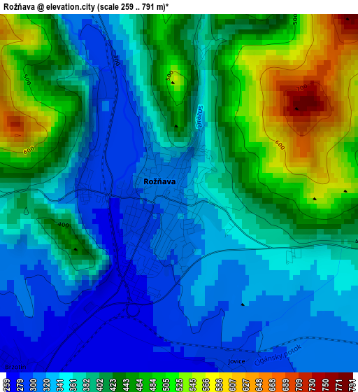
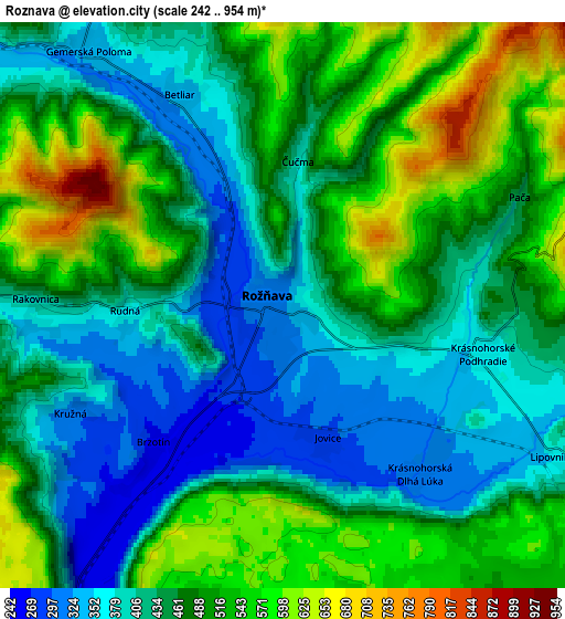
Below is the Elevation map of Rožňava, which displays elevation range with different colors. Scale of the first map is from 259 to 791 m (850 to 2595 ft) with average elevation of 393.5 meters (=1291 ft) [note 1]
These maps also provides idea of topography and contour of this city, they are displayed at different zoom levels. More info about maps, scale and edge coordinates you can find below images.
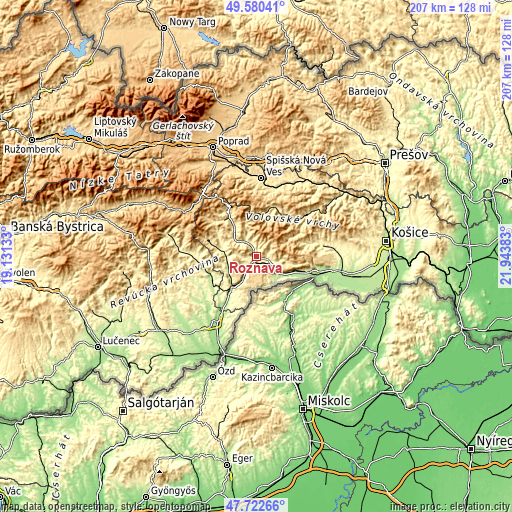
| \ | Map #1 | Map #2 | Topo.Map |
| Scale [m] | 259..791 m | 242..954 m | × |
| Scale [ft] | 850..2595 ft | 794..3130 ft | × |
| Average | 393.5 m = 1291 ft | 464.6 m = 1524 ft | × |
| Width | 6.45 km = 4 mi | 12.91 km = 8 mi | 206.6 km = 128.4 mi |
| Height | 6.45 km = 4 mi | 12.91 km = 8 mi | 206.5 km = 128.3 mi |
| ↑Max Latitude | 48.689109° | 48.718111° | 49.58041° |
| Latitude at center | 48.66009° | 48.66009° | 48.66009° |
| ↓Min Latitude | 48.631055° | 48.602003° | 47.72266° |
| ← Min Longitude | 20.493635° | 20.449689° | 19.13133° |
| Longitude center | 20.53758° | 20.53758° | 20.53758° |
| →Max Longitude | 20.581525° | 20.625471° | 21.94383° |
Nearby cities:
Cities around Rožňava sort by population:
• Poprad elevation 668 m
47.9 km,  338°
338°
• Spišská Nová Ves 459 m
31.7 km,  3°
3°
• Levoča 536 m
40.4 km,  5°
5°
• Revúca 318 m
31 km,  274°
274°
• Moldava nad Bodvou 209 m
34.3 km,  98°
98°
• Krompachy 380 m
37.6 km,  41°
41°
• Gelnica 363 m
36.5 km,  53°
53°
• Dobšiná 456 m
21.7 km,  325°
325°
• Tisovec 400 m
43.7 km, 272°
• Spišské Podhradie 434 m
41 km,  22°
22°
• Medzev 316 m
26.5 km,  80°
80°
• Žehra 418 m
40.1 km,  27°
27°
Multilingual:
 En español:
Rožňava elevación 318 m.
 En France:
Rožňava élévation 318 m.


Sources and notes:
- [note 1] Map square and city borders are not equal. Map elevation data is calculated only from area inside that square.
- [src 1] Elevation data from geonames database provided with same terms of usage.
- [src 2] The elevation map of Rožňava is generated using elevation data from NASA's 3 arcsec (90m) resolution SRTM data.
- [src 3] Base (background) map © OpenStreetMap contributors tiles are generated by Geofabrik and OpenTopoMap.
Copyright & License:
This Rožňava Elevation Map is licensed under CC BY-SA. You may reuse any part from this page, if you give a proper credit by linking to this URL:
 More info on terms of use page.