Žehra elevation
Žehra (Košický kraj, Okres Spišská Nová Ves), Slovakia elevation is 418 meters and Žehra elevation in feet is 1371 ft above sea level [src 1]. Žehra is a seat of a third-order administrative division (feature code) with elevation that is 98 meters (322 ft) bigger than average city elevation in Slovakia.
Below is the Elevation map of Žehra, which displays elevation range with different colors. Scale of the first map is from 383 to 669 m (1257 to 2195 ft) with average elevation of 477.4 meters (=1566 ft) [note 1]
These maps also provides idea of topography and contour of this city, they are displayed at different zoom levels. More info about maps, scale and edge coordinates you can find below images.
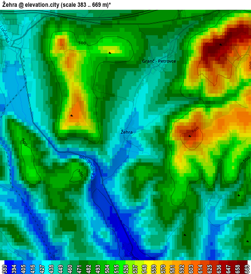
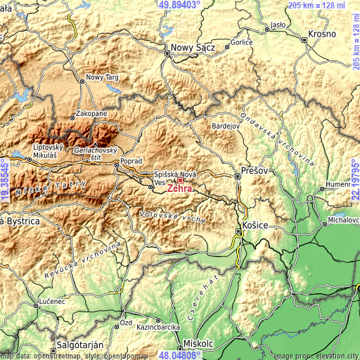
| \ | Map #1 | Topo.Map |
| Scale [m] | 383..669 m | × |
| Scale [ft] | 1257..2195 ft | × |
| Average | 477.4 m = 1566 ft | × |
| Width | 6.41 km = 4 mi | 205.3 km = 127.6 mi |
| Height | 6.41 km = 4 mi | 205.2 km = 127.5 mi |
| ↑Max Latitude | 49.008434° | 49.89403° |
| Latitude at center | 48.9796° | 48.9796° |
| ↓Min Latitude | 48.950749° | 48.04808° |
| ← Min Longitude | 20.747755° | 19.38545° |
| Longitude center | 20.7917° | 20.7917° |
| →Max Longitude | 20.835645° | 22.19795° |
Nearby cities:
Cities around Žehra sort by population:
• Prešov elevation 247 m
32.3 km,  86°
86°
• Spišská Nová Ves 459 m
17.2 km,  256°
256°
• Kežmarok 615 m
31.3 km,  303°
303°
• Levoča 536 m
15.3 km,  287°
287°
• Sabinov 318 m
26.3 km,  58°
58°
• Krompachy 380 m
9.5 km,  139°
139°
• Gelnica 363 m
17.4 km, 142°
• Lipany 387 m
23.1 km,  32°
32°
• Ľubica 633 m
29.2 km, 301°
• Spišské Podhradie 434 m
3.7 km,  310°
310°
• Medzev 316 m
31.9 km,  166°
166°
• Vrbov 652 m
29.3 km, 294°
Multilingual:
 En español:
Žehra elevación 418 m.
 En France:
Žehra élévation 418 m.
 Auf Deutsch:
Schigra, Žehra höhe über dem Meeresspiegel ist 418 m.

Sources and notes:
- [note 1] Map square and city borders are not equal. Map elevation data is calculated only from area inside that square.
- [src 1] Elevation data from geonames database provided with same terms of usage.
- [src 2] The elevation map of Žehra is generated using elevation data from NASA's 3 arcsec (90m) resolution SRTM data.
- [src 3] Base (background) map © OpenStreetMap contributors tiles are generated by Geofabrik and OpenTopoMap.
Copyright & License:
This Žehra Elevation Map is licensed under CC BY-SA. You may reuse any part from this page, if you give a proper credit by linking to this URL:
 More info on terms of use page.