Medzev elevation
Medzev (Košický kraj, Okres Kosice-okolie), Slovakia elevation is 316 meters and Medzev elevation in feet is 1037 ft above sea level [src 1]. Medzev is a populated place (feature code) with elevation that is 4 meters (13 ft) smaller than average city elevation in Slovakia.
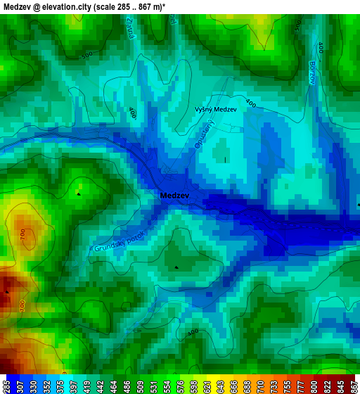
Below is the Elevation map of Medzev, which displays elevation range with different colors. Scale of the first map is from 285 to 867 m (935 to 2844 ft) with average elevation of 435.5 meters (=1429 ft) [note 1]
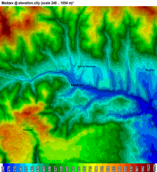
These maps also provides idea of topography and contour of this city, they are displayed at different zoom levels. More info about maps, scale and edge coordinates you can find below images.
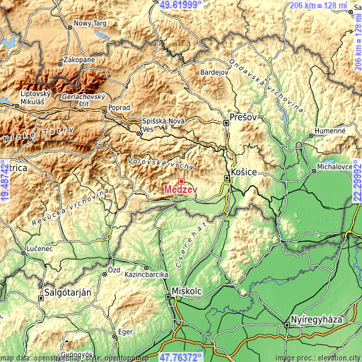
| \ | Map #1 | Map #2 | Topo.Map |
| Scale [m] | 285..867 m | 248..1054 m | × |
| Scale [ft] | 935..2844 ft | 814..3458 ft | × |
| Average | 435.5 m = 1429 ft | 544.9 m = 1788 ft | × |
| Width | 6.45 km = 4 mi | 12.9 km = 8 mi | 206.4 km = 128.3 mi |
| Height | 6.45 km = 4 mi | 12.9 km = 8 mi | 206.4 km = 128.3 mi |
| ↑Max Latitude | 48.729405° | 48.758384° | 49.61999° |
| Latitude at center | 48.70041° | 48.70041° | 48.70041° |
| ↓Min Latitude | 48.671398° | 48.642369° | 47.76372° |
| ← Min Longitude | 20.849725° | 20.805779° | 19.48742° |
| Longitude center | 20.89367° | 20.89367° | 20.89367° |
| →Max Longitude | 20.937615° | 20.981561° | 22.29992° |
Nearby cities:
Cities around Medzev sort by population:
• Košice elevation 205 m
26.8 km,  86°
86°
• Prešov 247 m
41.4 km,  36°
36°
• Spišská Nová Ves 459 m
36.5 km,  318°
318°
• Rožňava 318 m
26.5 km,  260°
260°
• Levoča 536 m
42 km,  328°
328°
• Moldava nad Bodvou 209 m
12.3 km,  140°
140°
• Krompachy 380 m
23.8 km,  356°
356°
• Gelnica 363 m
17.6 km,  10°
10°
• Dobšiná 456 m
40.7 km,  289°
289°
• Spišské Podhradie 434 m
35 km,  342°
342°
• Žehra 418 m
31.9 km,  346°
346°
• Kavečany 454 m
24.4 km,  69°
69°
Multilingual:
 En español:
Medzev elevación 316 m.
 En France:
Medzev élévation 316 m.


Sources and notes:
- [note 1] Map square and city borders are not equal. Map elevation data is calculated only from area inside that square.
- [src 1] Elevation data from geonames database provided with same terms of usage.
- [src 2] The elevation map of Medzev is generated using elevation data from NASA's 3 arcsec (90m) resolution SRTM data.
- [src 3] Base (background) map © OpenStreetMap contributors tiles are generated by Geofabrik and OpenTopoMap.
Copyright & License:
This Medzev Elevation Map is licensed under CC BY-SA. You may reuse any part from this page, if you give a proper credit by linking to this URL:
 More info on terms of use page.