Fritsla elevation
Fritsla (Västra Götaland, Marks Kommun), Sweden elevation is 85 meters and Fritsla elevation in feet is 279 ft above sea level [src 1]. Fritsla is a populated place (feature code) with elevation that is 10 meters (33 ft) bigger than average city elevation in Sweden.
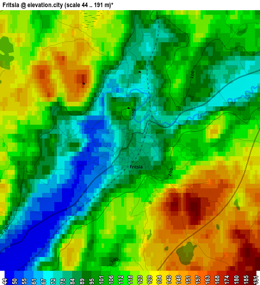
Below is the Elevation map of Fritsla, which displays elevation range with different colors. Scale of the first map is from 44 to 191 m (144 to 627 ft) with average elevation of 108.4 meters (=356 ft) [note 1]
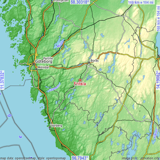
These maps also provides idea of topography and contour of this city, they are displayed at different zoom levels. More info about maps, scale and edge coordinates you can find below images.
| \ | Map #1 | Topo.Map |
| Scale [m] | 44..191 m | × |
| Scale [ft] | 144..627 ft | × |
| Average | 108.4 m = 356 ft | × |
| Width | 5.24 km = 3.3 mi | 167.8 km = 104.3 mi |
| Height | 5.24 km = 3.3 mi | 167.8 km = 104.3 mi |
| ↑Max Latitude | 57.580118° | 58.30318° |
| Latitude at center | 57.55655° | 57.55655° |
| ↓Min Latitude | 57.532967° | 56.7943° |
| ← Min Longitude | 12.740625° | 11.37832° |
| Longitude center | 12.78457° | 12.78457° |
| →Max Longitude | 12.828515° | 14.19082° |
Nearby cities:
Cities around Fritsla sort by population:
• Borås elevation 143 m
20.5 km,  26°
26°
• Kinna 65 m
7.7 km,  224°
224°
• Bollebygd 87 m
17.7 km,  314°
314°
• Viskafors 135 m
9 km, 25°
• Dalsjöfors 249 m
25.2 km,  44°
44°
• Svenljunga 149 m
20.6 km,  109°
109°
• Sandared 161 m
17.1 km,  1°
1°
• Hindås 140 m
25.9 km, 309°
• Sjömarken 161 m
17.9 km,  9°
9°
• Gånghester 219 m
21.1 km, 40°
• Rävlanda 65 m
20.2 km,  302°
302°
• Sätila 54 m
21 km,  265°
265°
Multilingual:
 En español:
Fritsla elevación 85 m.
 En France:
Fritsla élévation 85 m.


Sources and notes:
- [note 1] Map square and city borders are not equal. Map elevation data is calculated only from area inside that square.
- [src 1] Elevation data from geonames database provided with same terms of usage.
- [src 2] The elevation map of Fritsla is generated using elevation data from NASA's 3 arcsec (90m) resolution SRTM data.
- [src 3] Base (background) map © OpenStreetMap contributors tiles are generated by Geofabrik and OpenTopoMap.
Copyright & License:
This Fritsla Elevation Map is licensed under CC BY-SA. You may reuse any part from this page, if you give a proper credit by linking to this URL:
 More info on terms of use page.