Hindås elevation
Hindås (Västra Götaland, Härryda Kommun), Sweden elevation is 140 meters and Hindås elevation in feet is 459 ft above sea level [src 1]. Hindås is a populated place (feature code) with elevation that is 65 meters (213 ft) bigger than average city elevation in Sweden.
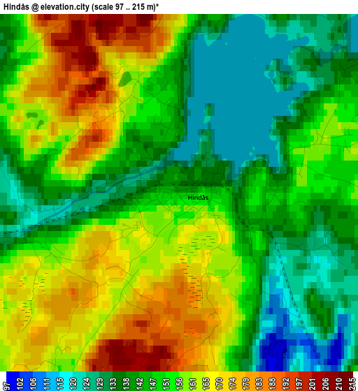
Below is the Elevation map of Hindås, which displays elevation range with different colors. Scale of the first map is from 97 to 215 m (318 to 705 ft) with average elevation of 151.4 meters (=497 ft) [note 1]
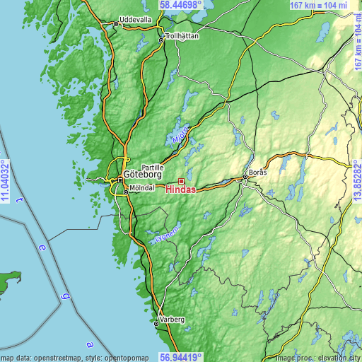
These maps also provides idea of topography and contour of this city, they are displayed at different zoom levels. More info about maps, scale and edge coordinates you can find below images.
| \ | Map #1 | Topo.Map |
| Scale [m] | 97..215 m | × |
| Scale [ft] | 318..705 ft | × |
| Average | 151.4 m = 497 ft | × |
| Width | 5.22 km = 3.2 mi | 167.1 km = 103.8 mi |
| Height | 5.22 km = 3.2 mi | 167.1 km = 103.8 mi |
| ↑Max Latitude | 57.726852° | 58.44698° |
| Latitude at center | 57.70338° | 57.70338° |
| ↓Min Latitude | 57.679892° | 56.94419° |
| ← Min Longitude | 12.402625° | 11.04032° |
| Longitude center | 12.44657° | 12.44657° |
| →Max Longitude | 12.490515° | 13.85282° |
Nearby cities:
Cities around Hindås sort by population:
• Lerum elevation 20 m
12.9 km,  305°
305°
• Landvetter 63 m
14.1 km,  262°
262°
• Gråbo 73 m
17.2 km,  329°
329°
• Öjersjö 133 m
18.5 km,  268°
268°
• Furulund 145 m
18.7 km, 274°
• Bollebygd 87 m
8.4 km,  117°
117°
• Olofstorp 72 m
19.8 km,  304°
304°
• Stenkullen 54 m
12.7 km,  322°
322°
• Ingared 79 m
17.4 km,  0°
0°
• Rävlanda 65 m
6.3 km,  151°
151°
• Sätila 54 m
18 km,  182°
182°
• Olstorp 98 m
16.7 km, 322°
Multilingual:
 En español:
Hindås elevación 140 m.
 En France:
Hindås élévation 140 m.


Sources and notes:
- [note 1] Map square and city borders are not equal. Map elevation data is calculated only from area inside that square.
- [src 1] Elevation data from geonames database provided with same terms of usage.
- [src 2] The elevation map of Hindås is generated using elevation data from NASA's 3 arcsec (90m) resolution SRTM data.
- [src 3] Base (background) map © OpenStreetMap contributors tiles are generated by Geofabrik and OpenTopoMap.
Copyright & License:
This Hindås Elevation Map is licensed under CC BY-SA. You may reuse any part from this page, if you give a proper credit by linking to this URL:
 More info on terms of use page.