Rävlanda elevation
Rävlanda (Västra Götaland, Härryda Kommun), Sweden elevation is 65 meters and Rävlanda elevation in feet is 213 ft above sea level [src 1]. Rävlanda is a populated place (feature code) with elevation that is 10 meters (33 ft) smaller than average city elevation in Sweden.
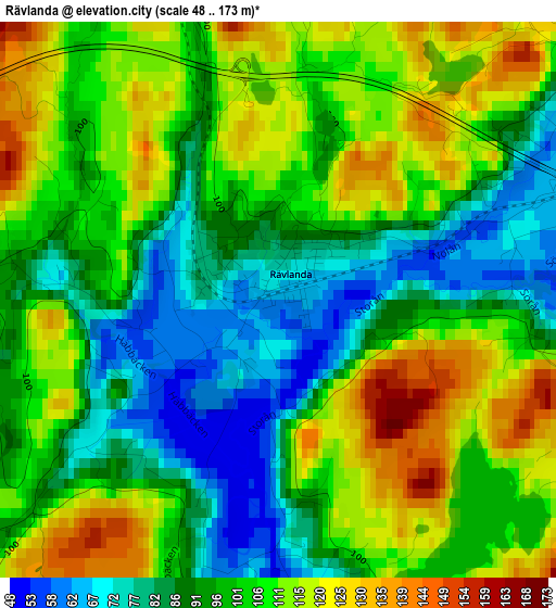
Below is the Elevation map of Rävlanda, which displays elevation range with different colors. Scale of the first map is from 48 to 173 m (157 to 568 ft) with average elevation of 101 meters (=331 ft) [note 1]
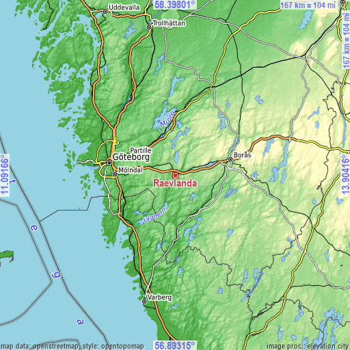
These maps also provides idea of topography and contour of this city, they are displayed at different zoom levels. More info about maps, scale and edge coordinates you can find below images.
| \ | Map #1 | Topo.Map |
| Scale [m] | 48..173 m | × |
| Scale [ft] | 157..568 ft | × |
| Average | 101 m = 331 ft | × |
| Width | 5.23 km = 3.2 mi | 167.3 km = 104 mi |
| Height | 5.23 km = 3.2 mi | 167.3 km = 104 mi |
| ↑Max Latitude | 57.676885° | 58.39801° |
| Latitude at center | 57.65338° | 57.65338° |
| ↓Min Latitude | 57.62986° | 56.89315° |
| ← Min Longitude | 12.453965° | 11.09166° |
| Longitude center | 12.49791° | 12.49791° |
| →Max Longitude | 12.541855° | 13.90416° |
Nearby cities:
Cities around Rävlanda sort by population:
• Lerum elevation 20 m
18.8 km,  313°
313°
• Kinna 65 m
20 km,  144°
144°
• Landvetter 63 m
17.4 km,  282°
282°
• Öjersjö 133 m
22.2 km, 283°
• Bollebygd 87 m
4.8 km,  69°
69°
• Viskafors 135 m
21.1 km,  97°
97°
• Sandared 161 m
18.6 km, 70°
• Hindås 140 m
6.3 km,  331°
331°
• Sjömarken 161 m
21.2 km, 71°
• Fritsla 85 m
20.2 km,  122°
122°
• Stenkullen 54 m
19 km, 325°
• Sätila 54 m
13 km,  196°
196°
Multilingual:
 En español:
Rävlanda elevación 65 m.
 En France:
Rävlanda élévation 65 m.


Sources and notes:
- [note 1] Map square and city borders are not equal. Map elevation data is calculated only from area inside that square.
- [src 1] Elevation data from geonames database provided with same terms of usage.
- [src 2] The elevation map of Rävlanda is generated using elevation data from NASA's 3 arcsec (90m) resolution SRTM data.
- [src 3] Base (background) map © OpenStreetMap contributors tiles are generated by Geofabrik and OpenTopoMap.
Copyright & License:
This Rävlanda Elevation Map is licensed under CC BY-SA. You may reuse any part from this page, if you give a proper credit by linking to this URL:
 More info on terms of use page.