Svenljunga elevation
Svenljunga (Västra Götaland, Svenljunga Kommun), Sweden elevation is 149 meters and Svenljunga elevation in feet is 489 ft above sea level [src 1]. Svenljunga is a seat of a second-order administrative division (feature code) with elevation that is 74 meters (243 ft) bigger than average city elevation in Sweden.
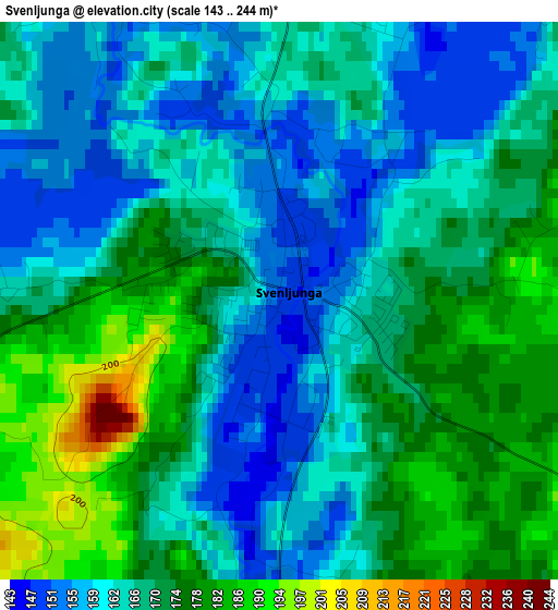
Below is the Elevation map of Svenljunga, which displays elevation range with different colors. Scale of the first map is from 143 to 244 m (469 to 801 ft) with average elevation of 167.9 meters (=551 ft) [note 1]
These maps also provides idea of topography and contour of this city, they are displayed at different zoom levels. More info about maps, scale and edge coordinates you can find below images.
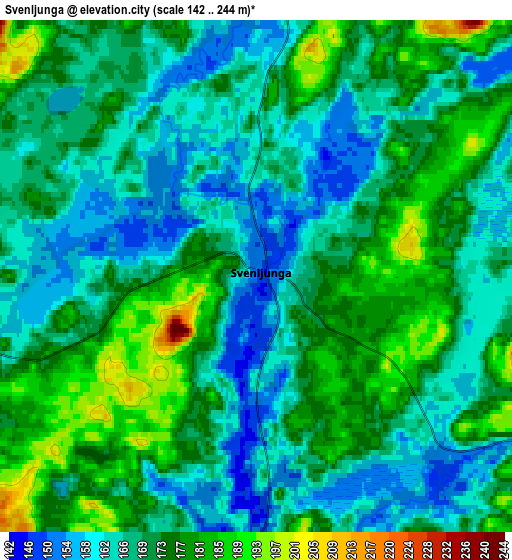
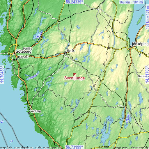
| \ | Map #1 | Map #2 | Topo.Map |
| Scale [m] | 143..244 m | 142..244 m | × |
| Scale [ft] | 469..801 ft | 466..801 ft | × |
| Average | 167.9 m = 551 ft | 170.2 m = 558 ft | × |
| Width | 5.25 km = 3.3 mi | 10.5 km = 6.5 mi | 168.1 km = 104.5 mi |
| Height | 5.25 km = 3.3 mi | 10.5 km = 6.5 mi | 168 km = 104.4 mi |
| ↑Max Latitude | 57.519117° | 57.542709° | 58.24339° |
| Latitude at center | 57.49551° | 57.49551° | 57.49551° |
| ↓Min Latitude | 57.471888° | 57.44825° | 56.73199° |
| ← Min Longitude | 13.066835° | 13.022889° | 11.70453° |
| Longitude center | 13.11078° | 13.11078° | 13.11078° |
| →Max Longitude | 13.154725° | 13.198671° | 14.51703° |
Nearby cities:
Cities around Svenljunga sort by population:
• Borås elevation 143 m
27.1 km,  337°
337°
• Kinna 65 m
24.9 km,  273°
273°
• Viskafors 135 m
21.6 km,  313°
313°
• Dalsjöfors 249 m
24.6 km,  356°
356°
• Tranemo 165 m
14.4 km,  95°
95°
• Sandared 161 m
30.5 km,  321°
321°
• Sjömarken 161 m
29.5 km,  326°
326°
• Gånghester 219 m
23.4 km,  346°
346°
• Fritsla 85 m
20.6 km,  289°
289°
• Limmared 169 m
15.3 km,  72°
72°
• Hestra 185 m
29.6 km, 101°
• Länghem 181 m
13.7 km,  32°
32°
Multilingual:
 En español:
Svenljunga elevación 149 m.
 En France:
Svenljunga élévation 149 m.
 Auf Deutsch:
Svenljunga höhe über dem Meeresspiegel ist 149 m.

Sources and notes:
- [note 1] Map square and city borders are not equal. Map elevation data is calculated only from area inside that square.
- [src 1] Elevation data from geonames database provided with same terms of usage.
- [src 2] The elevation map of Svenljunga is generated using elevation data from NASA's 3 arcsec (90m) resolution SRTM data.
- [src 3] Base (background) map © OpenStreetMap contributors tiles are generated by Geofabrik and OpenTopoMap.
Copyright & License:
This Svenljunga Elevation Map is licensed under CC BY-SA. You may reuse any part from this page, if you give a proper credit by linking to this URL:
 More info on terms of use page.