Svärdsjö elevation
Svärdsjö (Dalarna, Falu kommun), Sweden elevation is 132 meters and Svärdsjö elevation in feet is 433 ft above sea level [src 1]. Svärdsjö is a populated place (feature code) with elevation that is 57 meters (187 ft) bigger than average city elevation in Sweden.
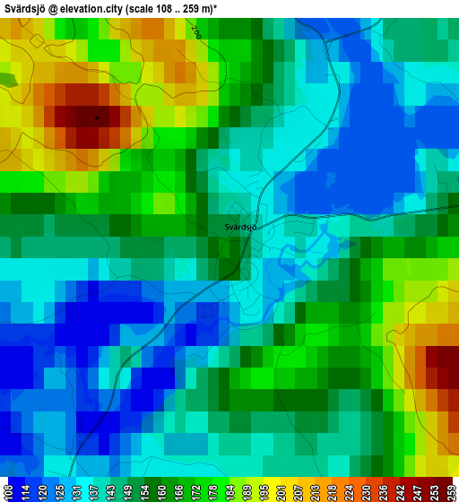
Below is the Elevation map of Svärdsjö, which displays elevation range with different colors. Scale of the first map is from 108 to 259 m (354 to 850 ft) with average elevation of 154.9 meters (=508 ft) [note 1]
These maps also provides idea of topography and contour of this city, they are displayed at different zoom levels. More info about maps, scale and edge coordinates you can find below images.
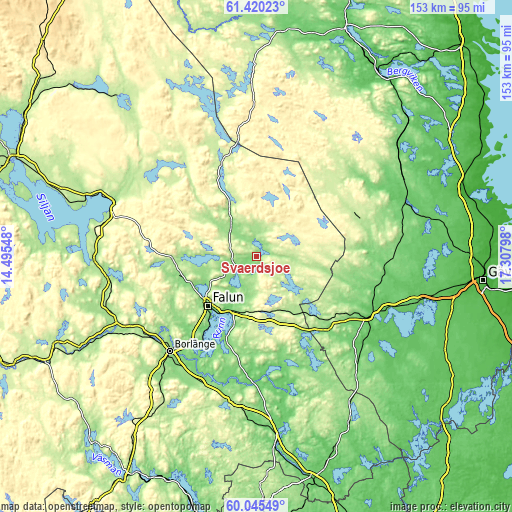
| \ | Map #1 | Topo.Map |
| Scale [m] | 108..259 m | × |
| Scale [ft] | 354..850 ft | × |
| Average | 154.9 m = 508 ft | × |
| Width | 4.78 km = 3 mi | 152.9 km = 95 mi |
| Height | 4.78 km = 3 mi | 152.8 km = 94.9 mi |
| ↑Max Latitude | 60.761692° | 61.42023° |
| Latitude at center | 60.74022° | 60.74022° |
| ↓Min Latitude | 60.718734° | 60.04549° |
| ← Min Longitude | 15.857785° | 14.49548° |
| Longitude center | 15.90173° | 15.90173° |
| →Max Longitude | 15.945675° | 17.30798° |
Nearby cities:
Cities around Svärdsjö sort by population:
• Borlänge elevation 124 m
38 km,  221°
221°
• Falun 97 m
21.4 km, 224°
• Hofors 114 m
30.1 km,  135°
135°
• Säter 151 m
44.4 km,  190°
190°
• Storvik 49 m
38.6 km,  116°
116°
• Bjursås 177 m
24.4 km,  269°
269°
• Enbacka 118 m
40.3 km,  204°
204°
• Grycksbo 159 m
23.4 km,  255°
255°
• Järbo 111 m
38.1 km,  93°
93°
• Romme 149 m
40.6 km,  212°
212°
• Långshyttan 104 m
32.9 km,  166°
166°
• Ornäs 108 m
32.3 km, 217°
Multilingual:
 En español:
Svärdsjö elevación 132 m.
 En France:
Svärdsjö élévation 132 m.
 Auf Deutsch:
Svärdsjö höhe über dem Meeresspiegel ist 132 m.

Sources and notes:
- [note 1] Map square and city borders are not equal. Map elevation data is calculated only from area inside that square.
- [src 1] Elevation data from geonames database provided with same terms of usage.
- [src 2] The elevation map of Svärdsjö is generated using GMTED2010 database with 7.5 arcsec (225m) resolution.
- [src 3] Base (background) map © OpenStreetMap contributors tiles are generated by Geofabrik and OpenTopoMap.
Copyright & License:
This Svärdsjö Elevation Map is licensed under CC BY-SA. You may reuse any part from this page, if you give a proper credit by linking to this URL:
 More info on terms of use page.