Falun elevation
Falun (Dalarna, Falu kommun), Sweden elevation is 97 meters and Falun elevation in feet is 318 ft above sea level [src 1]. Falun is a seat of a first-order administrative division (feature code) with elevation that is 22 meters (72 ft) bigger than average city elevation in Sweden.
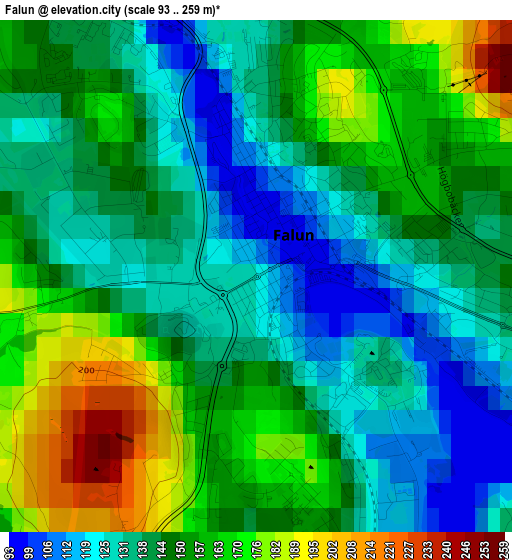
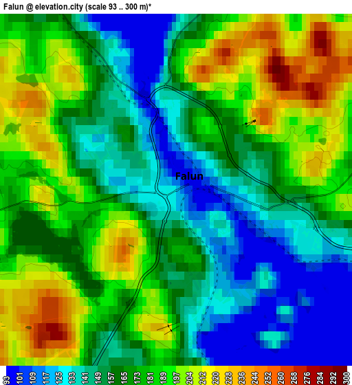
Below is the Elevation map of Falun, which displays elevation range with different colors. Scale of the first map is from 93 to 259 m (305 to 850 ft) with average elevation of 146.9 meters (=482 ft) [note 1]
These maps also provides idea of topography and contour of this city, they are displayed at different zoom levels. More info about maps, scale and edge coordinates you can find below images.
| \ | Map #1 | Map #2 | Topo.Map |
| Scale [m] | 93..259 m | 93..300 m | × |
| Scale [ft] | 305..850 ft | 305..984 ft | × |
| Average | 146.9 m = 482 ft | 168.7 m = 553 ft | × |
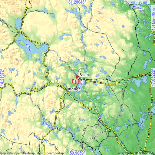
| Width | 4.8 km = 3 mi | 9.59 km = 6 mi | 153.5 km = 95.4 mi |
| Height | 4.8 km = 3 mi | 9.59 km = 6 mi | 153.5 km = 95.4 mi |
| ↑Max Latitude | 60.625133° | 60.646682° | 61.28648° |
| Latitude at center | 60.60357° | 60.60357° | 60.60357° |
| ↓Min Latitude | 60.581992° | 60.5604° | 59.9059° |
| ← Min Longitude | 15.582025° | 15.538079° | 14.21972° |
| Longitude center | 15.62597° | 15.62597° | 15.62597° |
| →Max Longitude | 15.669915° | 15.713861° | 17.03222° |
Nearby cities:
Cities around Falun sort by population:
• Borlänge elevation 124 m
16.7 km,  218°
218°
• Säter 151 m
29.2 km,  166°
166°
• Insjön 200 m
30.1 km,  285°
285°
• Djurås 172 m
27.4 km,  259°
259°
• Bjursås 177 m
17.6 km,  327°
327°
• Enbacka 118 m
21.6 km,  184°
184°
• Grycksbo 159 m
12.1 km,  320°
320°
• Romme 149 m
20.1 km,  200°
200°
• Långshyttan 104 m
28.1 km,  126°
126°
• Svärdsjö 132 m
21.4 km,  44°
44°
• Gagnef 172 m
29.9 km,  268°
268°
• Ornäs 108 m
11.4 km, 203°
Multilingual:
 En español:
Falun elevación 97 m.
 En France:
Falun élévation 97 m.


Sources and notes:
- [note 1] Map square and city borders are not equal. Map elevation data is calculated only from area inside that square.
- [src 1] Elevation data from geonames database provided with same terms of usage.
- [src 2] The elevation map of Falun is generated using GMTED2010 database with 7.5 arcsec (225m) resolution.
- [src 3] Base (background) map © OpenStreetMap contributors tiles are generated by Geofabrik and OpenTopoMap.
Copyright & License:
This Falun Elevation Map is licensed under CC BY-SA. You may reuse any part from this page, if you give a proper credit by linking to this URL:
 More info on terms of use page.