Järbo elevation
Järbo (Gävleborg, Sandvikens Kommun), Sweden elevation is 111 meters and Järbo elevation in feet is 364 ft above sea level [src 1]. Järbo is a populated place (feature code) with elevation that is 36 meters (118 ft) bigger than average city elevation in Sweden.
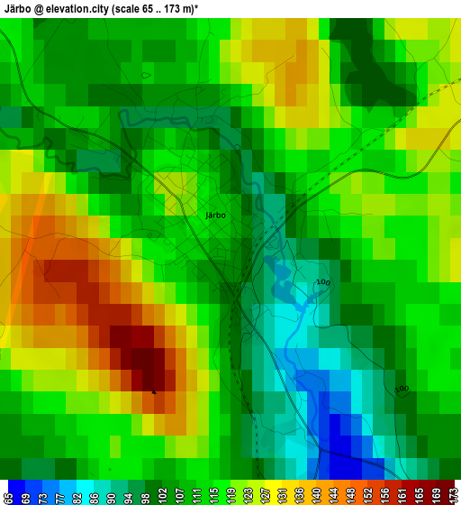
Below is the Elevation map of Järbo, which displays elevation range with different colors. Scale of the first map is from 65 to 173 m (213 to 568 ft) with average elevation of 114 meters (=374 ft) [note 1]
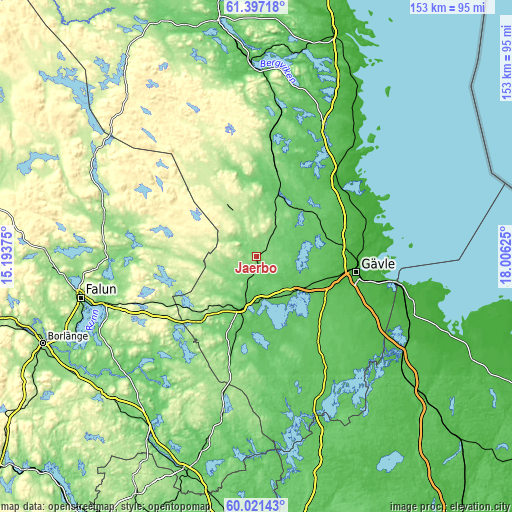
These maps also provides idea of topography and contour of this city, they are displayed at different zoom levels. More info about maps, scale and edge coordinates you can find below images.
| \ | Map #1 | Topo.Map |
| Scale [m] | 65..173 m | × |
| Scale [ft] | 213..568 ft | × |
| Average | 114 m = 374 ft | × |
| Width | 4.78 km = 3 mi | 153 km = 95.1 mi |
| Height | 4.78 km = 3 mi | 152.9 km = 95 mi |
| ↑Max Latitude | 60.738158° | 61.39718° |
| Latitude at center | 60.71667° | 60.71667° |
| ↓Min Latitude | 60.695168° | 60.02143° |
| ← Min Longitude | 16.556055° | 15.19375° |
| Longitude center | 16.6° | 16.6° |
| →Max Longitude | 16.643945° | 18.00625° |
Nearby cities:
Cities around Järbo sort by population:
• Gävle elevation 3 m
29.9 km,  99°
99°
• Sandviken 66 m
14.4 km,  140°
140°
• Valbo 17 m
24.7 km,  107°
107°
• Hofors 114 m
25.6 km,  221°
221°
• Ockelbo 59 m
20.4 km,  18°
18°
• Storvik 49 m
15.3 km,  193°
193°
• Forsbacka 52 m
19 km,  125°
125°
• Långshyttan 104 m
42.5 km,  226°
226°
• Bergby 17 m
33.7 km,  45°
45°
• Svärdsjö 132 m
38.1 km,  273°
273°
• Hedesunda 52 m
41.4 km,  148°
148°
• Årsunda 54 m
23.4 km,  161°
161°
Multilingual:
 En español:
Järbo elevación 111 m.
 En France:
Järbo élévation 111 m.


Sources and notes:
- [note 1] Map square and city borders are not equal. Map elevation data is calculated only from area inside that square.
- [src 1] Elevation data from geonames database provided with same terms of usage.
- [src 2] The elevation map of Järbo is generated using GMTED2010 database with 7.5 arcsec (225m) resolution.
- [src 3] Base (background) map © OpenStreetMap contributors tiles are generated by Geofabrik and OpenTopoMap.
Copyright & License:
This Järbo Elevation Map is licensed under CC BY-SA. You may reuse any part from this page, if you give a proper credit by linking to this URL:
 More info on terms of use page.