Korocha elevation
Korocha (Belgorod Oblast), Russia elevation is 195 meters and Korocha elevation in feet is 640 ft above sea level [src 1]. Korocha is a populated place (feature code) with elevation that is 4 meters (13 ft) smaller than average city elevation in Russia.
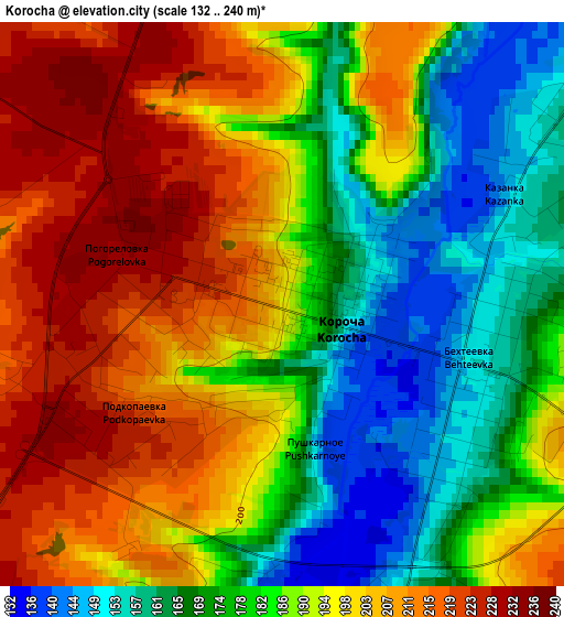
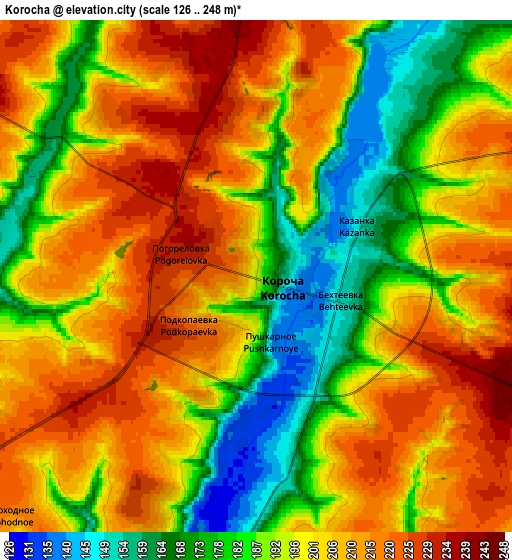
Below is the Elevation map of Korocha, which displays elevation range with different colors. Scale of the first map is from 132 to 240 m (433 to 787 ft) with average elevation of 189.5 meters (=622 ft) [note 1]
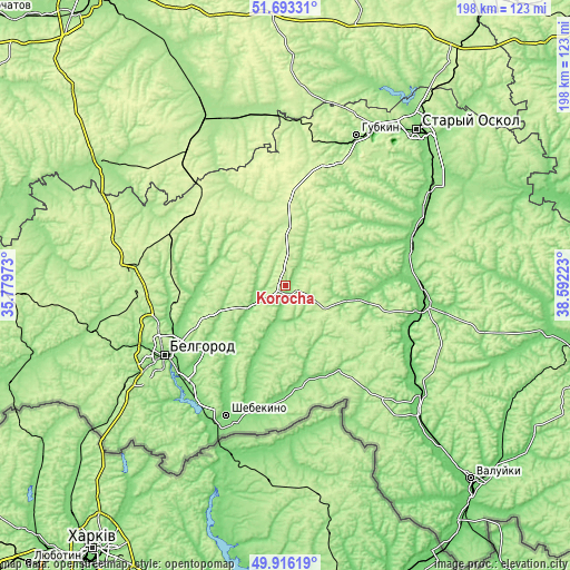
These maps also provides idea of topography and contour of this city, they are displayed at different zoom levels. More info about maps, scale and edge coordinates you can find below images.
| \ | Map #1 | Map #2 | Topo.Map |
| Scale [m] | 132..240 m | 126..248 m | × |
| Scale [ft] | 433..787 ft | 413..814 ft | × |
| Average | 189.5 m = 622 ft | 198.5 m = 651 ft | × |
| Width | 6.17 km = 3.8 mi | 12.35 km = 7.7 mi | 197.6 km = 122.8 mi |
| Height | 6.17 km = 3.8 mi | 12.35 km = 7.7 mi | 197.6 km = 122.8 mi |
| ↑Max Latitude | 50.840959° | 50.868701° | 51.69331° |
| Latitude at center | 50.8132° | 50.8132° | 50.8132° |
| ↓Min Latitude | 50.785425° | 50.757633° | 49.91619° |
| ← Min Longitude | 37.142035° | 37.098089° | 35.77973° |
| Longitude center | 37.18598° | 37.18598° | 37.18598° |
| →Max Longitude | 37.229925° | 37.273871° | 38.59223° |
Nearby cities:
Cities around Korocha sort by population:
• Belgorod elevation 173 m
48.2 km,  242°
242°
• Shebekino 113 m
48.8 km,  203°
203°
• Novyy Oskol 112 m
48 km,  96°
96°
• Stroitel’ 240 m
49.5 km,  266°
266°
• Razumnoye 126 m
47 km,  228°
228°
• Chernyanka 122 m
45.8 km,  71°
71°
• Prokhorovka 256 m
40.4 km,  308°
308°
• Severnyy 211 m
47 km,  251°
251°
• Maslova Pristan’ 118 m
51.4 km,  219°
219°
• Skorodnoye 227 m
28.8 km,  5°
5°
• Bekhteyevka 216 m
2.3 km,  105°
105°
• Gorod Shebekino 105 m
48 km, 203°
Multilingual:
 En español:
Korocha elevación 195 m.
 En France:
Korocha élévation 195 m.


Sources and notes:
- [note 1] Map square and city borders are not equal. Map elevation data is calculated only from area inside that square.
- [src 1] Elevation data from geonames database provided with same terms of usage.
- [src 2] The elevation map of Korocha is generated using elevation data from NASA's 3 arcsec (90m) resolution SRTM data.
- [src 3] Base (background) map © OpenStreetMap contributors tiles are generated by Geofabrik and OpenTopoMap.
Copyright & License:
This Korocha Elevation Map is licensed under CC BY-SA. You may reuse any part from this page, if you give a proper credit by linking to this URL:
 More info on terms of use page.