Chernyanka elevation
Chernyanka (Belgorod Oblast), Russia elevation is 122 meters and Chernyanka elevation in feet is 400 ft above sea level [src 1]. Chernyanka is a populated place (feature code) with elevation that is 77 meters (253 ft) smaller than average city elevation in Russia.
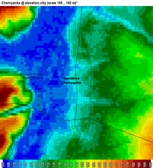
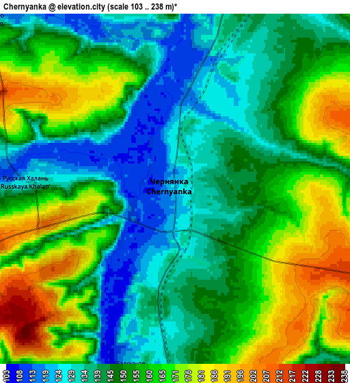
Below is the Elevation map of Chernyanka, which displays elevation range with different colors. Scale of the first map is from 105 to 192 m (344 to 630 ft) with average elevation of 130.2 meters (=427 ft) [note 1]
These maps also provides idea of topography and contour of this city, they are displayed at different zoom levels. More info about maps, scale and edge coordinates you can find below images.
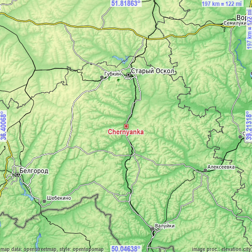
| \ | Map #1 | Map #2 | Topo.Map |
| Scale [m] | 105..192 m | 103..238 m | × |
| Scale [ft] | 344..630 ft | 338..781 ft | × |
| Average | 130.2 m = 427 ft | 151.9 m = 498 ft | × |
| Width | 6.16 km = 3.8 mi | 12.32 km = 7.7 mi | 197.1 km = 122.5 mi |
| Height | 6.16 km = 3.8 mi | 12.32 km = 7.7 mi | 197 km = 122.4 mi |
| ↑Max Latitude | 50.968633° | 50.996299° | 51.81863° |
| Latitude at center | 50.94095° | 50.94095° | 50.94095° |
| ↓Min Latitude | 50.913251° | 50.885535° | 50.04638° |
| ← Min Longitude | 37.762985° | 37.719039° | 36.40068° |
| Longitude center | 37.80693° | 37.80693° | 37.80693° |
| →Max Longitude | 37.850875° | 37.894821° | 39.21318° |
Nearby cities:
Cities around Chernyanka sort by population:
• Staryy Oskol elevation 139 m
39.6 km,  3°
3°
• Gubkin 168 m
42 km,  334°
334°
• Rossosh’ 107 m
53.2 km,  67°
67°
• Novyy Oskol 112 m
20.2 km,  168°
168°
• Volokonovka 103 m
51.1 km,  176°
176°
• Krasnogvardeyskoye 120 m
53 km,  127°
127°
• Troitskiy 241 m
50.4 km,  337°
337°
• Korocha 195 m
45.8 km,  251°
251°
• Zasosna 112 m
53.9 km, 129°
• Skorodnoye 227 m
43 km,  289°
289°
• Bekhteyevka 216 m
43.9 km, 250°
• Rogovatoye 206 m
51.4 km,  51°
51°
Multilingual:
 En español:
Chernyanka elevación 122 m.
 En France:
Chernyanka élévation 122 m.
 Auf Deutsch:
Chernyanka höhe über dem Meeresspiegel ist 122 m.

Sources and notes:
- [note 1] Map square and city borders are not equal. Map elevation data is calculated only from area inside that square.
- [src 1] Elevation data from geonames database provided with same terms of usage.
- [src 2] The elevation map of Chernyanka is generated using elevation data from NASA's 3 arcsec (90m) resolution SRTM data.
- [src 3] Base (background) map © OpenStreetMap contributors tiles are generated by Geofabrik and OpenTopoMap.
Copyright & License:
This Chernyanka Elevation Map is licensed under CC BY-SA. You may reuse any part from this page, if you give a proper credit by linking to this URL:
 More info on terms of use page.