Stroitel’ elevation
Stroitel’ (Belgorod Oblast), Russia elevation is 240 meters and Stroitel’ elevation in feet is 787 ft above sea level [src 1]. Stroitel’ is a populated place (feature code) with elevation that is 41 meters (135 ft) bigger than average city elevation in Russia.
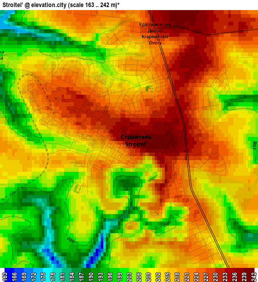
Below is the Elevation map of Stroitel’, which displays elevation range with different colors. Scale of the first map is from 163 to 242 m (535 to 794 ft) with average elevation of 213.4 meters (=700 ft) [note 1]
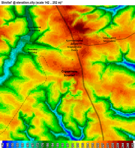
These maps also provides idea of topography and contour of this city, they are displayed at different zoom levels. More info about maps, scale and edge coordinates you can find below images.
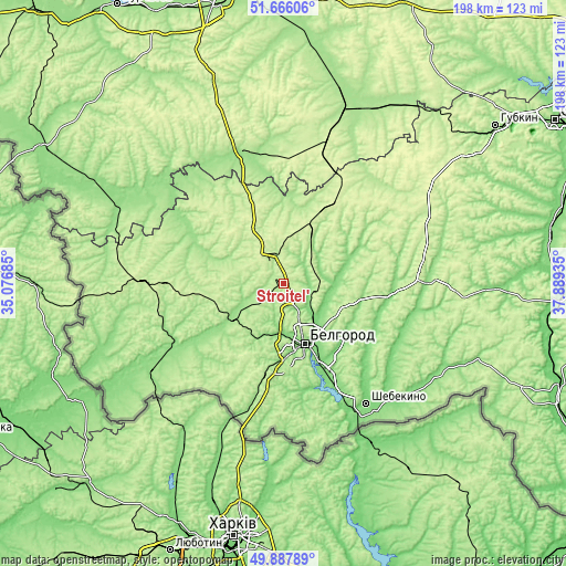
| \ | Map #1 | Map #2 | Topo.Map |
| Scale [m] | 163..242 m | 142..252 m | × |
| Scale [ft] | 535..794 ft | 466..827 ft | × |
| Average | 213.4 m = 700 ft | 205.6 m = 675 ft | × |
| Width | 6.18 km = 3.8 mi | 12.36 km = 7.7 mi | 197.7 km = 122.8 mi |
| Height | 6.18 km = 3.8 mi | 12.36 km = 7.7 mi | 197.7 km = 122.8 mi |
| ↑Max Latitude | 50.813205° | 50.840964° | 51.66606° |
| Latitude at center | 50.78543° | 50.78543° | 50.78543° |
| ↓Min Latitude | 50.757638° | 50.72983° | 49.88789° |
| ← Min Longitude | 36.439155° | 36.395209° | 35.07685° |
| Longitude center | 36.4831° | 36.4831° | 36.4831° |
| →Max Longitude | 36.527045° | 36.570991° | 37.88935° |
Nearby cities:
Cities around Stroitel’ sort by population:
• Belgorod elevation 173 m
20.6 km,  160°
160°
• Razumnoye 126 m
31.3 km,  153°
153°
• Borisovka 140 m
38.8 km,  238°
238°
• Rakitnoye 193 m
44.8 km,  277°
277°
• Prokhorovka 256 m
33 km,  31°
31°
• Tomarovka 151 m
20.9 km, 237°
• Ivnya 221 m
39.4 km,  321°
321°
• Severnyy 211 m
13 km, 157°
• Mayskiy 180 m
29.6 km,  183°
183°
• Maslova Pristan’ 118 m
40.1 km, 155°
• Bessonovka 201 m
31.5 km,  204°
204°
• Yakovlevo 200 m
8.7 km,  343°
343°
Multilingual:
 En español:
Stroitel’ elevación 240 m.
 En France:
Stroitel’ élévation 240 m.
 Auf Deutsch:
Stroitel’ höhe über dem Meeresspiegel ist 240 m.

Sources and notes:
- [note 1] Map square and city borders are not equal. Map elevation data is calculated only from area inside that square.
- [src 1] Elevation data from geonames database provided with same terms of usage.
- [src 2] The elevation map of Stroitel’ is generated using elevation data from NASA's 3 arcsec (90m) resolution SRTM data.
- [src 3] Base (background) map © OpenStreetMap contributors tiles are generated by Geofabrik and OpenTopoMap.
Copyright & License:
This Stroitel’ Elevation Map is licensed under CC BY-SA. You may reuse any part from this page, if you give a proper credit by linking to this URL:
 More info on terms of use page.