Letnik elevation
Letnik (Rostov), Russia elevation is 44 meters and Letnik elevation in feet is 144 ft above sea level [src 1]. Letnik is a populated place (feature code) with elevation that is 155 meters (509 ft) smaller than average city elevation in Russia.
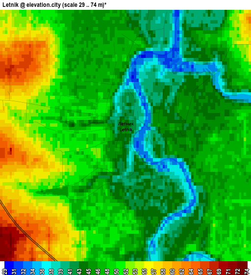
Below is the Elevation map of Letnik, which displays elevation range with different colors. Scale of the first map is from 29 to 74 m (95 to 243 ft) with average elevation of 48.1 meters (=158 ft) [note 1]
These maps also provides idea of topography and contour of this city, they are displayed at different zoom levels. More info about maps, scale and edge coordinates you can find below images.
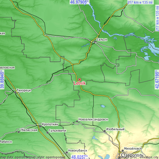
| \ | Map #1 | Topo.Map |
| Scale [m] | 29..74 m | × |
| Scale [ft] | 95..243 ft | × |
| Average | 48.1 m = 158 ft | × |
| Width | 6.79 km = 4.2 mi | 217.2 km = 135 mi |
| Height | 6.79 km = 4.2 mi | 217.2 km = 135 mi |
| ↑Max Latitude | 46.041512° | 46.97905° |
| Latitude at center | 46.011° | 46.011° |
| ↓Min Latitude | 45.980471° | 45.0257° |
| ← Min Longitude | 41.221755° | 39.85945° |
| Longitude center | 41.2657° | 41.2657° |
| →Max Longitude | 41.309645° | 42.67195° |
Nearby cities:
Cities around Letnik sort by population:
• Novopokrovskaya elevation 61 m
44.2 km,  261°
261°
• Belaya Glina 51 m
31.7 km,  283°
283°
• Krasnogvardeyskoye 51 m
26.8 km,  133°
133°
• Peschanokopskoye 76 m
24.9 km,  325°
325°
• Gorodovikovsk 66 m
52.2 km,  80°
80°
• Rasshevatskaya 85 m
51.7 km,  200°
200°
• Ladovskaya Balka 99 m
43.7 km,  165°
165°
• Uspenskaya 68 m
31.4 km,  209°
209°
• Sandata 35 m
47.7 km,  52°
52°
• Krasnaya Polyana 37 m
21.4 km,  58°
58°
• Pregradnoye 65 m
42.8 km,  119°
119°
• Kubanskiy 96 m
53.7 km, 260°
Multilingual:
 En español:
Letnik elevación 44 m.
 En France:
Letnik élévation 44 m.


Sources and notes:
- [note 1] Map square and city borders are not equal. Map elevation data is calculated only from area inside that square.
- [src 1] Elevation data from geonames database provided with same terms of usage.
- [src 2] The elevation map of Letnik is generated using elevation data from NASA's 3 arcsec (90m) resolution SRTM data.
- [src 3] Base (background) map © OpenStreetMap contributors tiles are generated by Geofabrik and OpenTopoMap.
Copyright & License:
This Letnik Elevation Map is licensed under CC BY-SA. You may reuse any part from this page, if you give a proper credit by linking to this URL:
 More info on terms of use page.