Kubanskiy elevation
Kubanskiy (Krasnodarskiy), Russia elevation is 96 meters and Kubanskiy elevation in feet is 315 ft above sea level [src 1]. Kubanskiy is a populated place (feature code) with elevation that is 103 meters (338 ft) smaller than average city elevation in Russia.
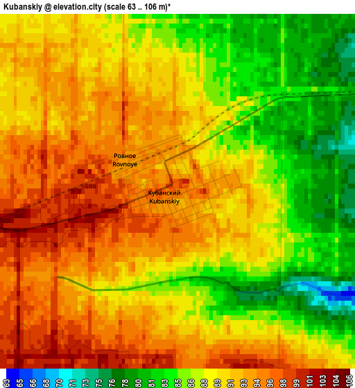
Below is the Elevation map of Kubanskiy, which displays elevation range with different colors. Scale of the first map is from 63 to 106 m (207 to 348 ft) with average elevation of 89.6 meters (=294 ft) [note 1]
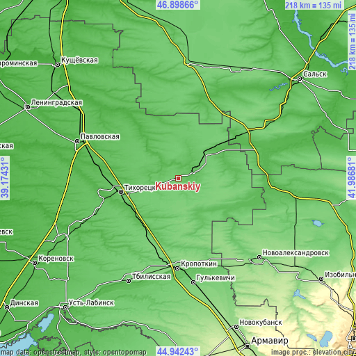
These maps also provides idea of topography and contour of this city, they are displayed at different zoom levels. More info about maps, scale and edge coordinates you can find below images.
| \ | Map #1 | Topo.Map |
| Scale [m] | 63..106 m | × |
| Scale [ft] | 207..348 ft | × |
| Average | 89.6 m = 294 ft | × |
| Width | 6.8 km = 4.2 mi | 217.5 km = 135.1 mi |
| Height | 6.8 km = 4.2 mi | 217.5 km = 135.1 mi |
| ↑Max Latitude | 45.959728° | 46.89866° |
| Latitude at center | 45.92917° | 45.92917° |
| ↓Min Latitude | 45.898596° | 44.94243° |
| ← Min Longitude | 40.536615° | 39.17431° |
| Longitude center | 40.58056° | 40.58056° |
| →Max Longitude | 40.624505° | 41.98681° |
Nearby cities:
Cities around Kubanskiy sort by population:
• Tikhoretsk elevation 81 m
36.2 km,  256°
256°
• Novopokrovskaya 61 m
9.6 km,  75°
75°
• Belaya Glina 51 m
27.6 km,  53°
53°
• Fastovetskaya 52 m
32.6 km,  267°
267°
• Novoleushkovskaya 42 m
46.1 km,  279°
279°
• Ternevskaya 79 m
15.6 km,  236°
236°
• Kalnibolotskaya 47 m
12.8 km,  311°
311°
• Uspenskaya 68 m
41.9 km,  115°
115°
• Parkovyy 78 m
35.3 km,  252°
252°
• Dmitriyevskaya 70 m
33.5 km,  154°
154°
• Alekseyevskaya 51 m
37.3 km, 242°
• Mirskoy 115 m
45.1 km,  198°
198°
Multilingual:
 En español:
Kubanskiy elevación 96 m.
 En France:
Kubanskiy élévation 96 m.
 Auf Deutsch:
Kubanskiy höhe über dem Meeresspiegel ist 96 m.

Sources and notes:
- [note 1] Map square and city borders are not equal. Map elevation data is calculated only from area inside that square.
- [src 1] Elevation data from geonames database provided with same terms of usage.
- [src 2] The elevation map of Kubanskiy is generated using elevation data from NASA's 3 arcsec (90m) resolution SRTM data.
- [src 3] Base (background) map © OpenStreetMap contributors tiles are generated by Geofabrik and OpenTopoMap.
Copyright & License:
This Kubanskiy Elevation Map is licensed under CC BY-SA. You may reuse any part from this page, if you give a proper credit by linking to this URL:
 More info on terms of use page.