Sandata elevation
Sandata (Rostov), Russia elevation is 35 meters and Sandata elevation in feet is 115 ft above sea level [src 1]. Sandata is a populated place (feature code) with elevation that is 164 meters (538 ft) smaller than average city elevation in Russia.
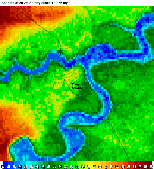
Below is the Elevation map of Sandata, which displays elevation range with different colors. Scale of the first map is from 17 to 56 m (56 to 184 ft) with average elevation of 33.3 meters (=109 ft) [note 1]
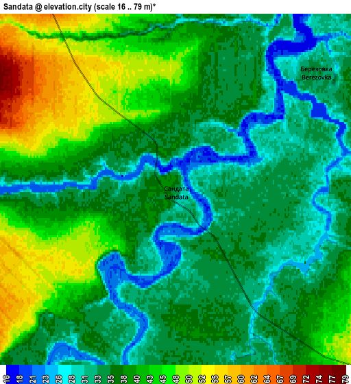
These maps also provides idea of topography and contour of this city, they are displayed at different zoom levels. More info about maps, scale and edge coordinates you can find below images.
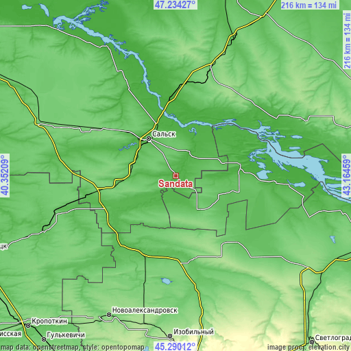
| \ | Map #1 | Map #2 | Topo.Map |
| Scale [m] | 17..56 m | 16..79 m | × |
| Scale [ft] | 56..184 ft | 52..259 ft | × |
| Average | 33.3 m = 109 ft | 37.9 m = 124 ft | × |
| Width | 6.76 km = 4.2 mi | 13.51 km = 8.4 mi | 216.2 km = 134.3 mi |
| Height | 6.76 km = 4.2 mi | 13.51 km = 8.4 mi | 216.2 km = 134.3 mi |
| ↑Max Latitude | 46.301179° | 46.331531° | 47.23427° |
| Latitude at center | 46.27081° | 46.27081° | 46.27081° |
| ↓Min Latitude | 46.240424° | 46.210022° | 45.29012° |
| ← Min Longitude | 41.714395° | 41.670449° | 40.35209° |
| Longitude center | 41.75834° | 41.75834° | 41.75834° |
| →Max Longitude | 41.802285° | 41.846231° | 43.16459° |
Nearby cities:
Cities around Sandata sort by population:
• Sal’sk elevation 38 m
28.1 km,  323°
323°
• Proletarsk 21 m
48.1 km,  357°
357°
• Krasnogvardeyskoye 51 m
50.7 km,  201°
201°
• Peschanokopskoye 76 m
52.7 km,  260°
260°
• Gorodoviki 76 m
21.9 km,  133°
133°
• Gigant 71 m
41.3 km,  309°
309°
• Gorodovikovsk 66 m
24.4 km,  146°
146°
• Yashalta 28 m
40.5 km,  79°
79°
• Novyy Yegorlyk 30 m
16.1 km,  32°
32°
• Krasnaya Polyana 37 m
26.4 km,  228°
228°
• Pregradnoye 65 m
49.9 km,  181°
181°
• Letnik 44 m
47.7 km, 232°
Multilingual:
 En español:
Sandata elevación 35 m.
 En France:
Sandata élévation 35 m.


Sources and notes:
- [note 1] Map square and city borders are not equal. Map elevation data is calculated only from area inside that square.
- [src 1] Elevation data from geonames database provided with same terms of usage.
- [src 2] The elevation map of Sandata is generated using elevation data from NASA's 3 arcsec (90m) resolution SRTM data.
- [src 3] Base (background) map © OpenStreetMap contributors tiles are generated by Geofabrik and OpenTopoMap.
Copyright & License:
This Sandata Elevation Map is licensed under CC BY-SA. You may reuse any part from this page, if you give a proper credit by linking to this URL:
 More info on terms of use page.