Strugi-Krasnyye elevation
Strugi-Krasnyye (Pskov Oblast), Russia elevation is 127 meters and Strugi-Krasnyye elevation in feet is 417 ft above sea level [src 1]. Strugi-Krasnyye is a populated place (feature code) with elevation that is 72 meters (236 ft) smaller than average city elevation in Russia.
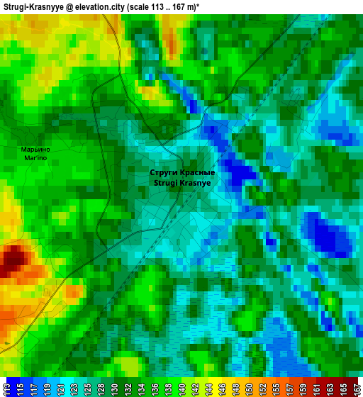
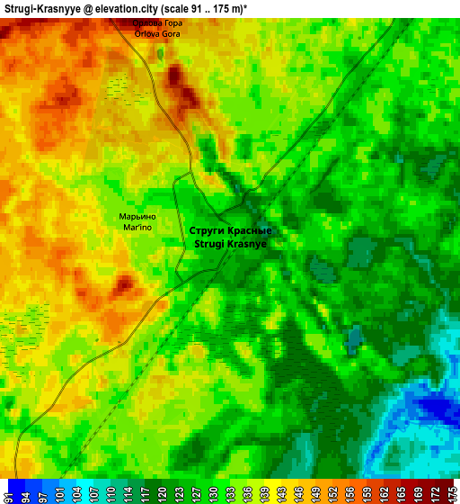
Below is the Elevation map of Strugi-Krasnyye, which displays elevation range with different colors. Scale of the first map is from 113 to 167 m (371 to 548 ft) with average elevation of 131.4 meters (=431 ft) [note 1]
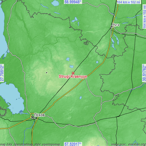
These maps also provides idea of topography and contour of this city, they are displayed at different zoom levels. More info about maps, scale and edge coordinates you can find below images.
| \ | Map #1 | Map #2 | Topo.Map |
| Scale [m] | 113..167 m | 91..175 m | × |
| Scale [ft] | 371..548 ft | 299..574 ft | × |
| Average | 131.4 m = 431 ft | 133 m = 436 ft | × |
| Width | 5.14 km = 3.2 mi | 10.28 km = 6.4 mi | 164.5 km = 102.2 mi |
| Height | 5.14 km = 3.2 mi | 10.28 km = 6.4 mi | 164.5 km = 102.2 mi |
| ↑Max Latitude | 58.290646° | 58.313736° | 58.99948° |
| Latitude at center | 58.26754° | 58.26754° | 58.26754° |
| ↓Min Latitude | 58.244419° | 58.221283° | 57.52017° |
| ← Min Longitude | 29.067425° | 29.023479° | 27.70512° |
| Longitude center | 29.11137° | 29.11137° | 29.11137° |
| →Max Longitude | 29.155315° | 29.199261° | 30.51762° |
Nearby cities:
Cities around Strugi-Krasnyye sort by population:
• Pskov elevation 51 m
67.5 km,  221°
221°
• Luga 59 m
67.4 km,  39°
39°
• Porkhov 53 m
61.7 km,  154°
154°
• Sol’tsy 23 m
72.8 km,  102°
102°
• Dno 71 m
70 km,  134°
134°
• Gdov 43 m
91.9 km,  305°
305°
• Plyussa 70 m
23.4 km, 39°
• Serëdka 64 m
55.6 km,  257°
257°
• Tolmachevo 62 m
80.5 km, 35°
• Batetskiy 69 m
81.1 km,  58°
58°
• Utorgosh 45 m
66.8 km,  88°
88°
• Novyy Izborsk 64 m
86.9 km,  230°
230°
Multilingual:
 En español:
Strugi-Krasnyye elevación 127 m.
 En France:
Strugi-Krasnyye élévation 127 m.
 Auf Deutsch:
Strugi-Krasnyye höhe über dem Meeresspiegel ist 127 m.

Sources and notes:
- [note 1] Map square and city borders are not equal. Map elevation data is calculated only from area inside that square.
- [src 1] Elevation data from geonames database provided with same terms of usage.
- [src 2] The elevation map of Strugi-Krasnyye is generated using elevation data from NASA's 3 arcsec (90m) resolution SRTM data.
- [src 3] Base (background) map © OpenStreetMap contributors tiles are generated by Geofabrik and OpenTopoMap.
Copyright & License:
This Strugi-Krasnyye Elevation Map is licensed under CC BY-SA. You may reuse any part from this page, if you give a proper credit by linking to this URL:
 More info on terms of use page.