Sol’tsy elevation
Sol’tsy (Novgorod Oblast), Russia elevation is 23 meters and Sol’tsy elevation in feet is 75 ft above sea level [src 1]. Sol’tsy is a populated place (feature code) with elevation that is 176 meters (577 ft) smaller than average city elevation in Russia.
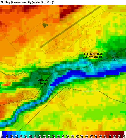
Below is the Elevation map of Sol’tsy, which displays elevation range with different colors. Scale of the first map is from 17 to 53 m (56 to 174 ft) with average elevation of 36.9 meters (=121 ft) [note 1]
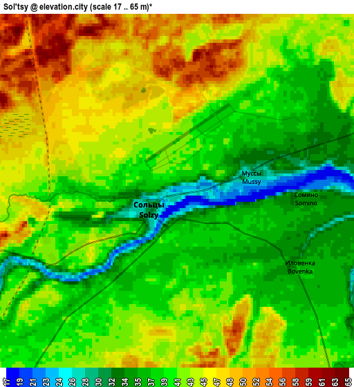
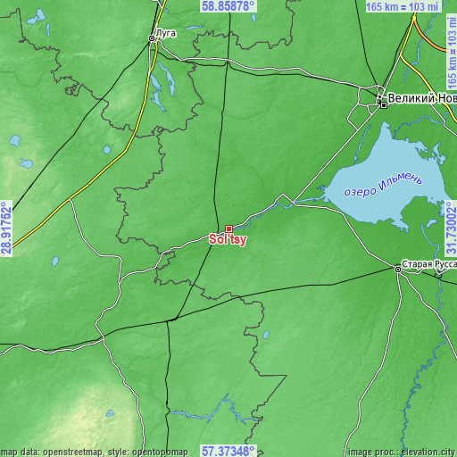
These maps also provides idea of topography and contour of this city, they are displayed at different zoom levels. More info about maps, scale and edge coordinates you can find below images.
| \ | Map #1 | Map #2 | Topo.Map |
| Scale [m] | 17..53 m | 17..65 m | × |
| Scale [ft] | 56..174 ft | 56..213 ft | × |
| Average | 36.9 m = 121 ft | 41.3 m = 135 ft | × |
| Width | 5.16 km = 3.2 mi | 10.32 km = 6.4 mi | 165.1 km = 102.6 mi |
| Height | 5.16 km = 3.2 mi | 10.32 km = 6.4 mi | 165.1 km = 102.6 mi |
| ↑Max Latitude | 58.147069° | 58.170253° | 58.85878° |
| Latitude at center | 58.12387° | 58.12387° | 58.12387° |
| ↓Min Latitude | 58.100656° | 58.077426° | 57.37348° |
| ← Min Longitude | 30.279825° | 30.235879° | 28.91752° |
| Longitude center | 30.32377° | 30.32377° | 30.32377° |
| →Max Longitude | 30.367715° | 30.411661° | 31.73002° |
Nearby cities:
Cities around Sol’tsy sort by population:
• Velikiy Novgorod elevation 35 m
70.8 km,  51°
51°
• Staraya Russa 27 m
62.7 km,  103°
103°
• Porkhov 53 m
60.4 km,  228°
228°
• Pankovka 25 m
66.1 km, 50°
• Dno 71 m
39.2 km,  212°
212°
• Dedovichi 85 m
67.4 km,  199°
199°
• Strugi-Krasnyye 127 m
72.8 km,  282°
282°
• Shimsk 29 m
24.8 km,  66°
66°
• Plyussa 70 m
65.6 km,  301°
301°
• Volot 78 m
31.2 km,  134°
134°
• Batetskiy 69 m
58.1 km,  358°
358°
• Utorgosh 45 m
18 km,  346°
346°
Multilingual:
 En español:
Sol’tsy elevación 23 m.
 En France:
Sol’tsy élévation 23 m.


Sources and notes:
- [note 1] Map square and city borders are not equal. Map elevation data is calculated only from area inside that square.
- [src 1] Elevation data from geonames database provided with same terms of usage.
- [src 2] The elevation map of Sol’tsy is generated using elevation data from NASA's 3 arcsec (90m) resolution SRTM data.
- [src 3] Base (background) map © OpenStreetMap contributors tiles are generated by Geofabrik and OpenTopoMap.
Copyright & License:
This Sol’tsy Elevation Map is licensed under CC BY-SA. You may reuse any part from this page, if you give a proper credit by linking to this URL:
 More info on terms of use page.