Gdov elevation
Gdov (Pskov Oblast), Russia elevation is 43 meters and Gdov elevation in feet is 141 ft above sea level [src 1]. Gdov is a populated place (feature code) with elevation that is 156 meters (512 ft) smaller than average city elevation in Russia.
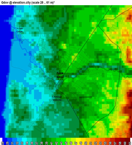
Below is the Elevation map of Gdov, which displays elevation range with different colors. Scale of the first map is from 28 to 61 m (92 to 200 ft) with average elevation of 39.2 meters (=129 ft) [note 1]
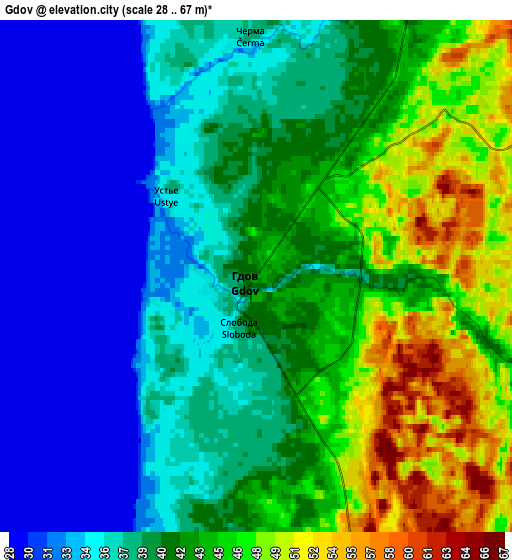
These maps also provides idea of topography and contour of this city, they are displayed at different zoom levels. More info about maps, scale and edge coordinates you can find below images.
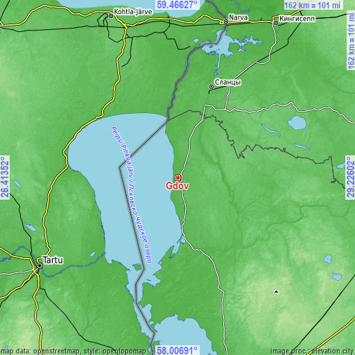
| \ | Map #1 | Map #2 | Topo.Map |
| Scale [m] | 28..61 m | 28..67 m | × |
| Scale [ft] | 92..200 ft | 92..220 ft | × |
| Average | 39.2 m = 129 ft | 39.7 m = 130 ft | × |
| Width | 5.07 km = 3.2 mi | 10.14 km = 6.3 mi | 162.3 km = 100.8 mi |
| Height | 5.07 km = 3.2 mi | 10.14 km = 6.3 mi | 162.2 km = 100.8 mi |
| ↑Max Latitude | 58.767034° | 58.789813° | 59.46627° |
| Latitude at center | 58.74424° | 58.74424° | 58.74424° |
| ↓Min Latitude | 58.721431° | 58.698607° | 58.00691° |
| ← Min Longitude | 27.775825° | 27.731879° | 26.41352° |
| Longitude center | 27.81977° | 27.81977° | 27.81977° |
| →Max Longitude | 27.863715° | 27.907661° | 29.22602° |
Nearby cities:
Cities around Gdov sort by population:
• Pskov elevation 51 m
108 km,  163°
163°
• Kingisepp 27 m
83.4 km,  32°
32°
• Luga 59 m
116.9 km,  90°
90°
• Slantsy 41 m
44.4 km,  20°
20°
• Pechory 92 m
103.9 km,  186°
186°
• Ivangorod 34 m
73.3 km, 18°
• Strugi-Krasnyye 127 m
91.9 km,  125°
125°
• Plyussa 70 m
96.1 km,  111°
111°
• Serëdka 64 m
68.5 km, 161°
• Ust’-Luga 4 m
106.1 km,  14°
14°
• Novyy Izborsk 64 m
108.6 km,  175°
175°
• Izborsk 82 m
115.3 km, 178°
Multilingual:
 En español:
Gdov elevación 43 m.
 En France:
Gdov élévation 43 m.


Sources and notes:
- [note 1] Map square and city borders are not equal. Map elevation data is calculated only from area inside that square.
- [src 1] Elevation data from geonames database provided with same terms of usage.
- [src 2] The elevation map of Gdov is generated using elevation data from NASA's 3 arcsec (90m) resolution SRTM data.
- [src 3] Base (background) map © OpenStreetMap contributors tiles are generated by Geofabrik and OpenTopoMap.
Copyright & License:
This Gdov Elevation Map is licensed under CC BY-SA. You may reuse any part from this page, if you give a proper credit by linking to this URL:
 More info on terms of use page.