Tolbazy elevation
Tolbazy (Bashkortostan Republic), Russia elevation is 213 meters and Tolbazy elevation in feet is 699 ft above sea level [src 1]. Tolbazy is a populated place (feature code) with elevation that is 14 meters (46 ft) bigger than average city elevation in Russia.
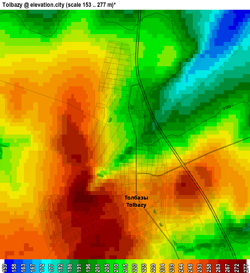
Below is the Elevation map of Tolbazy, which displays elevation range with different colors. Scale of the first map is from 153 to 277 m (502 to 909 ft) with average elevation of 225.2 meters (=739 ft) [note 1]
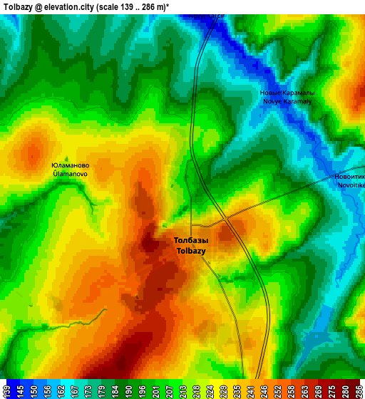
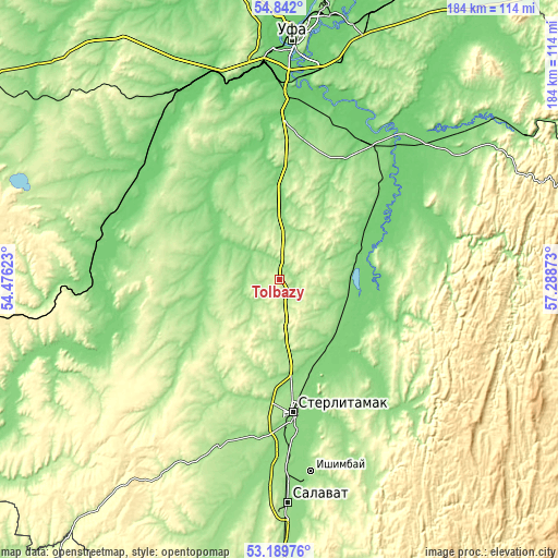
These maps also provides idea of topography and contour of this city, they are displayed at different zoom levels. More info about maps, scale and edge coordinates you can find below images.
| \ | Map #1 | Map #2 | Topo.Map |
| Scale [m] | 153..277 m | 139..286 m | × |
| Scale [ft] | 502..909 ft | 456..938 ft | × |
| Average | 225.2 m = 739 ft | 209.3 m = 687 ft | × |
| Width | 5.74 km = 3.6 mi | 11.48 km = 7.1 mi | 183.7 km = 114.1 mi |
| Height | 5.74 km = 3.6 mi | 11.48 km = 7.1 mi | 183.7 km = 114.1 mi |
| ↑Max Latitude | 54.049887° | 54.075679° | 54.842° |
| Latitude at center | 54.02408° | 54.02408° | 54.02408° |
| ↓Min Latitude | 53.998257° | 53.972417° | 53.18976° |
| ← Min Longitude | 55.838535° | 55.794589° | 54.47623° |
| Longitude center | 55.88248° | 55.88248° | 55.88248° |
| →Max Longitude | 55.926425° | 55.970371° | 57.28873° |
Nearby cities:
Cities around Tolbazy sort by population:
• Sterlitamak elevation 148 m
44.6 km,  174°
174°
• Salavat 159 m
71.2 km,  178°
178°
• Ishimbay 160 m
64.2 km, 170°
• Davlekanovo 127 m
59.5 km,  291°
291°
• Chishmy 107 m
69.6 km,  331°
331°
• Rayevskiy 110 m
61.3 km,  274°
274°
• Karmaskaly 130 m
43.3 km,  26°
26°
• Avdon 177 m
72.3 km,  351°
351°
• Ulukulevo 100 m
53.9 km, 31°
• Bulgakovo 108 m
52.6 km,  0°
0°
• Chesnokovka 95 m
65.5 km, 3°
• Kabakovo 98 m
59.6 km,  17°
17°
Multilingual:
 En español:
Tolbazy elevación 213 m.
 En France:
Tolbazy élévation 213 m.


Sources and notes:
- [note 1] Map square and city borders are not equal. Map elevation data is calculated only from area inside that square.
- [src 1] Elevation data from geonames database provided with same terms of usage.
- [src 2] The elevation map of Tolbazy is generated using elevation data from NASA's 3 arcsec (90m) resolution SRTM data.
- [src 3] Base (background) map © OpenStreetMap contributors tiles are generated by Geofabrik and OpenTopoMap.
Copyright & License:
This Tolbazy Elevation Map is licensed under CC BY-SA. You may reuse any part from this page, if you give a proper credit by linking to this URL:
 More info on terms of use page.