Ulukulevo elevation
Ulukulevo (Bashkortostan Republic), Russia elevation is 100 meters and Ulukulevo elevation in feet is 328 ft above sea level [src 1]. Ulukulevo is a populated place (feature code) with elevation that is 99 meters (325 ft) smaller than average city elevation in Russia.
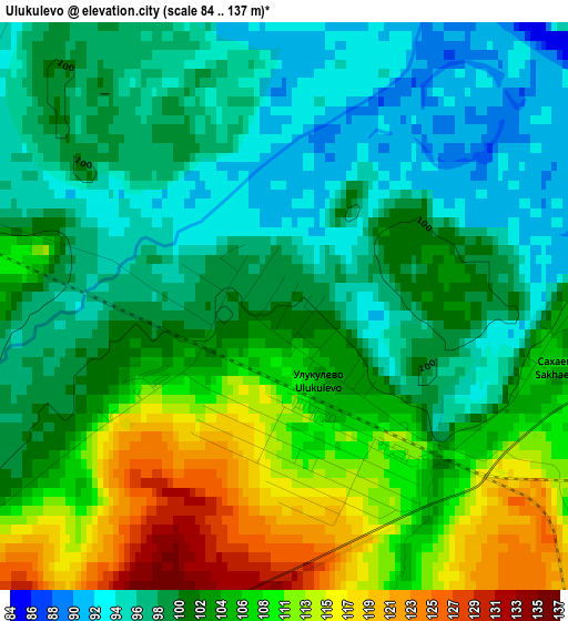
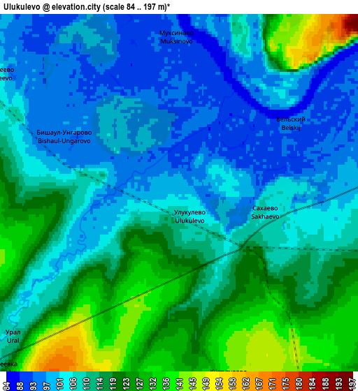
Below is the Elevation map of Ulukulevo, which displays elevation range with different colors. Scale of the first map is from 84 to 137 m (276 to 449 ft) with average elevation of 103.2 meters (=339 ft) [note 1]
These maps also provides idea of topography and contour of this city, they are displayed at different zoom levels. More info about maps, scale and edge coordinates you can find below images.
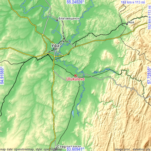
| \ | Map #1 | Map #2 | Topo.Map |
| Scale [m] | 84..137 m | 84..197 m | × |
| Scale [ft] | 276..449 ft | 276..646 ft | × |
| Average | 103.2 m = 339 ft | 110.7 m = 363 ft | × |
| Width | 5.68 km = 3.5 mi | 11.37 km = 7.1 mi | 181.9 km = 113 mi |
| Height | 5.68 km = 3.5 mi | 11.37 km = 7.1 mi | 181.9 km = 113 mi |
| ↑Max Latitude | 54.461051° | 54.486587° | 55.24526° |
| Latitude at center | 54.4355° | 54.4355° | 54.4355° |
| ↓Min Latitude | 54.409933° | 54.384349° | 53.60941° |
| ← Min Longitude | 56.278155° | 56.234209° | 54.91585° |
| Longitude center | 56.3221° | 56.3221° | 56.3221° |
| →Max Longitude | 56.366045° | 56.409991° | 57.72835° |
Nearby cities:
Cities around Ulukulevo sort by population:
• Ufa elevation 158 m
41.1 km,  326°
326°
• Chishmy 107 m
63 km,  284°
284°
• Iglino 114 m
44.5 km,  7°
7°
• Tolbazy 213 m
53.9 km,  211°
211°
• Karmaskaly 130 m
11.5 km,  231°
231°
• Avdon 177 m
46.7 km,  303°
303°
• Mikhaylovka 97 m
49.5 km, 326°
• Bulgakovo 108 m
29.1 km, 283°
• Chesnokovka 95 m
31.3 km,  309°
309°
• Kabakovo 98 m
15.8 km,  315°
315°
• Kudeyevskiy 187 m
56.4 km,  29°
29°
• Urman 145 m
61.1 km,  35°
35°
Multilingual:
 En español:
Ulukulevo elevación 100 m.
 En France:
Ulukulevo élévation 100 m.
 Auf Deutsch:
Ulukulevo höhe über dem Meeresspiegel ist 100 m.

Sources and notes:
- [note 1] Map square and city borders are not equal. Map elevation data is calculated only from area inside that square.
- [src 1] Elevation data from geonames database provided with same terms of usage.
- [src 2] The elevation map of Ulukulevo is generated using elevation data from NASA's 3 arcsec (90m) resolution SRTM data.
- [src 3] Base (background) map © OpenStreetMap contributors tiles are generated by Geofabrik and OpenTopoMap.
Copyright & License:
This Ulukulevo Elevation Map is licensed under CC BY-SA. You may reuse any part from this page, if you give a proper credit by linking to this URL:
 More info on terms of use page.