Ishimbay elevation
Ishimbay (Bashkortostan Republic), Russia elevation is 160 meters and Ishimbay elevation in feet is 525 ft above sea level [src 1]. Ishimbay is a populated place (feature code) with elevation that is 39 meters (128 ft) smaller than average city elevation in Russia.
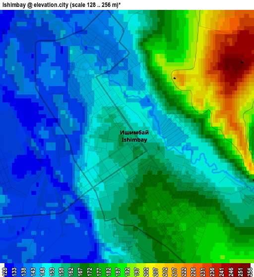
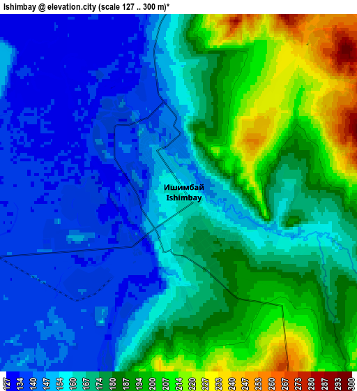
Below is the Elevation map of Ishimbay, which displays elevation range with different colors. Scale of the first map is from 128 to 256 m (420 to 840 ft) with average elevation of 160.8 meters (=528 ft) [note 1]
These maps also provides idea of topography and contour of this city, they are displayed at different zoom levels. More info about maps, scale and edge coordinates you can find below images.
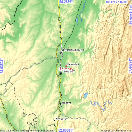
| \ | Map #1 | Map #2 | Topo.Map |
| Scale [m] | 128..256 m | 127..300 m | × |
| Scale [ft] | 420..840 ft | 417..984 ft | × |
| Average | 160.8 m = 528 ft | 169.5 m = 556 ft | × |
| Width | 5.82 km = 3.6 mi | 11.64 km = 7.2 mi | 186.2 km = 115.7 mi |
| Height | 5.82 km = 3.6 mi | 11.64 km = 7.2 mi | 186.2 km = 115.7 mi |
| ↑Max Latitude | 53.48062° | 53.506763° | 54.2836° |
| Latitude at center | 53.45446° | 53.45446° | 53.45446° |
| ↓Min Latitude | 53.428284° | 53.402092° | 52.60881° |
| ← Min Longitude | 55.997545° | 55.953599° | 54.63524° |
| Longitude center | 56.04149° | 56.04149° | 56.04149° |
| →Max Longitude | 56.085435° | 56.129381° | 57.44774° |
Nearby cities:
Cities around Ishimbay sort by population:
• Sterlitamak elevation 148 m
19.9 km,  342°
342°
• Salavat 159 m
11.9 km,  228°
228°
• Meleuz 179 m
54.9 km,  187°
187°
• Kumertau 285 m
78.4 km, 192°
• Tolbazy 213 m
64.2 km,  350°
350°
• Kirgiz-Miyaki 221 m
84.5 km,  283°
283°
• Yermolayevo 251 m
83.6 km, 191°
• Sterlibashevo 254 m
51.9 km,  267°
267°
• Yumaguzino 209 m
65.5 km,  159°
159°
• Zirgan 157 m
27.1 km,  197°
197°
• Mayachnyy 308 m
88.9 km, 195°
• Voskresenskoye 190 m
37.5 km,  169°
169°
Multilingual:
 En español:
Ishimbay elevación 160 m.
 En France:
Ishimbay élévation 160 m.
 Auf Deutsch:
Ishimbay höhe über dem Meeresspiegel ist 160 m.

Sources and notes:
- [note 1] Map square and city borders are not equal. Map elevation data is calculated only from area inside that square.
- [src 1] Elevation data from geonames database provided with same terms of usage.
- [src 2] The elevation map of Ishimbay is generated using elevation data from NASA's 3 arcsec (90m) resolution SRTM data.
- [src 3] Base (background) map © OpenStreetMap contributors tiles are generated by Geofabrik and OpenTopoMap.
Copyright & License:
This Ishimbay Elevation Map is licensed under CC BY-SA. You may reuse any part from this page, if you give a proper credit by linking to this URL:
 More info on terms of use page.